
"SUPPOSE YOU'RE WRONG THIS TIME?"
-Comment made by Kenneth Welsh, playing the Vice President in Day After Tomorrow to paleoclimatologist Jack Hall, played by Dennis Quaid when he suggests the climate is changing.
2:30 PM Update - SUNDAY 2/25
If you reside in the Mid-Atlantic area near the DC-Baltimore-Philly Metro areas, obviously what you see out your window would indicate a few changes to the forecast are in order.
The unexpectedly heavier snow is occuring due to a couple factors. The wedge of cold air was more entrenched across the coastal plain than computer models had indicated. Despite overnight temperatures not falling to far, the orientation of the airmass was more widespread in a north to south arrangement (along the East Coast) than in the East-West setup in the Valentine's Day Storm. As a professional meteorologist dutifully noted in the chat feature last night... we were concerned about the marginal aspect of surface temperatures. He made a point that has rung loud and clear today. Upward motion. The strong onshore flow into the Northeast and Mid-Atlantic caused by the tandem combination of the decaying Midwest low and the High pressure ridge setup from Canada down to the south east provided ample moisture. For simplicity sake, let me explain it this way by saying Atlantic moisture is riding in along the coastal plain, striking the pervasive dome of "cool" air, (not really cold) forcing it upward quickly.
The moisture then falls through the cool air at upper levels, crystallizing into snow. As it falls, the snow slowly evaporates, creating what I discussed yesterday...evaporative cooling. This in turn chills the atmosphere and brings the air temperature near the surface "down with the snow." It is a perfect example of micro- to mesoscale atmospheric dynamics. Proof is in thermometer at your house..dropping all day when climatology this time of year suggests sun angle among other things should send that temperature up. The result? A chilled air mass which can produce a hefty amount of snow in a short time even during maximum daytime heating, overcoming subpar temperatures at the surface.
HOW LONG WILL THE SNOW LAST ?
WILL A SECONDARY LOW FORM ALONG THE COAST ?
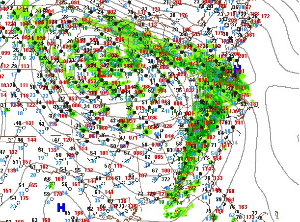
Review with me the current surface observations from Penn State's e-Wall. Notiee position of that teensy high around the Delaware Bay? I think that's inhibiting development of the secondary. You cannot have a surface Low forming in the same place as a Surface High. That's the Theory of Reciprocity, right Physics teachers? There can be an upper level low contaminating a surface High, or a weak Low next to a weak High, but not both in the same place at the same time. Momentum from the eastward pivoting dry line behind the cold/occluded front associated with the maturing Midwest low is simply flushing all the moisture to the coast. There it meets enhancement from Atlantic moisture being sent onshore by the double-barrel nature of air flow around both pressure systems. (Counterclockwise for the Low, clockwise for the High). So where is the Secondary Low to form? If it does, it will probably be weak, and have little or no effect on the final outcome of the precip in the Mid-Atlantic right now. Perhaps it will form under the High somewhere in North Carolina, but certainly not along the DelMarVa coast, at least not until pressure falls can indicate the High has decayed enough to allow for a pressure difference.
THE SNOW? WELL, THE BAD NEWS IS IT WON'T LAST LONG. Once that sharp back edge works it's way to the coast, that's probably it for those of you in northern/central Maryland. Redevelopment of a secondary isn't going to happen quickly enough to wrap a lot of energy back around and keep the snow going....there's too great of a north-northeastward motion for that I think. Energy for an explosive coastal low has basically been sapped out. What about the freezing rain that was originally predicted? That may still happen, but I am thinking not anywhere to the extent that was first believed, which is a good thing. There are still many nuances yet to uncover in this drama, and I may have to come back and re-unexplain myself if it changes again. Just remember the headline up top.
BUT THE REAL ANSWER YOU WANT TO KNOW: SCHOOL ON MONDAY?
If snow ends this afternoon, and air behind it is not cold or below 32, and DC-Baltimore metro areas get cut off from the High pressure source region, I could see this snow starting to melt right away. Crews would have many hours to clean up, overnight temps are not projected to sink into the 20's regionwide, all of which makes me lean towards a delay rather than closed for many schools in affected counties of Maryland.
I'll take a look at things again later this afternoon after I get some snow cleared off the sidewalks. Enjoy it now while it lasts. This time of year it'll start falling off the trees quickly and become clumpy and wet before long. If you have a digital camera, snap some nice pictures from your area and I'll be introducing a photo sharing feature on here using flickr.com (that is.. if school closes tomorrow!) Meanwhile, our weather spotters across the land of education... I guess it's time we start the traditional scientifically based speculation on school tomorrow. What are your thoughts on it?
"BABY, BABY...
LOOKS LIKE IT'S GONNA HAPPEN."
-artist and title unknown, maybe the Stray Cats?
Ready or not, here it comes. With a projected liquid equivalent of anywhere from .5 to 1.25 inches, this will be a juicy event for Maryland, Virginia, the Del-Mar-Va, Pennsylvania and New Jersey. Be sure to check your local NWS sites for changes in the advisories. I have no major changes to my forecast except to say that temperatures today will determine extent of frozen vs. liquid precip. If northern Maryland receives the widespread icing indicated by NWS, (up to 1/2 inch freezing rain) then school Monday is in jeopardy for those areas (Frederick, Carroll, Baltimore, Harford, Cecil counties). More information later. Please post your observations in the comments or the storm chat center. I will not be able to participate in either until this afternoon, so will talk to you all then.
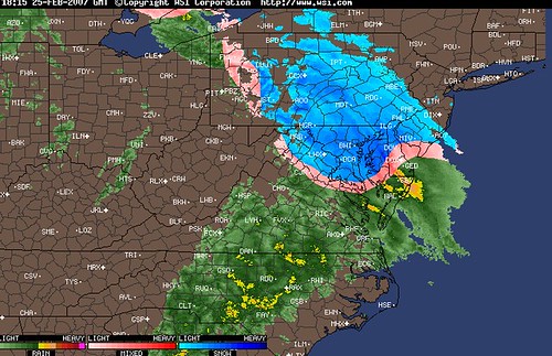
Special note of thanks to Mr. B in Greencastle, PA for providing this link to the neatest looking radar program I've ever seen, the image above of which is a capture from this morning. Bookmark that one for sure and I'll be adding it in the links soon.