
"I'M MAD AT H---, AND I'M
NOT GOING TO TAKE THIS ANYMORE!"
EARLY SPRING COASTAL STORM TO DRENCH MID-ATLANTIC
AND DUMP ON NEW ENGLAND TODAY AND THURSDAY
MID-ATLANTIC: Okay, so this is NOT the big snowstorm that I originally thought in early March would end the season right about now. for those of you who read the Dundalk Eagle article and are still waiting for the snow, looks like it is heading to New England. You obviously notice the temperatures even in Baltimore will only reach 45 F today, which is almost 15 degrees below normal. That is significant in considering had all this rain been snow, it would most certainly have been the Ultra Kahuna, with 1-2 feet of wind-whipped heavy wet snow to boot. But it is the Ultra Kahuna-rainstorm that I knew we needed to get the atmosphere cleared out and set back in order. In fact, this will be the first in a series of rain events to take us right through to next Monday. Clearing skies on Thursday sandwiches some sunshine before the weekend storm arrives.
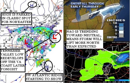
INTERIOR NORTHEAST / NEW ENGLAND: The hits just keep on coming. I indicated this storm was on the books last Saturday, and sure enough it is on time with the heaviest snow expected overnight into Thursday. There are a couple factors which you can see for yourself will influence the outcome of this storm. The most important I believe are the NAO trending toward neutral again. This will allow the storm to nudge a little farther north than currently expected, forcing the Boston, MA and Upton, NY NWS to extend the Winter Storm Watches to include areas north of I-90. The Canadian High is parked in the perfect spot, the Tennessee Valley Low will redevelop a secondary off Virginia. The moist air inflow from the ocean, the overnight timing, evaporative cooling, fresh snowpack...lah de dah dah. All great factors that point to a significant early Spring snowfall. Meanwhile the diehards down here in nosnowland just sit on the couch in total despair. We can't go out and garden, we can't shovel snow, all we can do is watch and weep.
STORM GRADE AMOUNTS: Accuweather seems on target with their amounts. You'll notice Boston is inside their 3-6" range, which would give credence to the idea of a northward shift. It is also possible the High overpowers and sends the storm farther out to sea earlier, but this seems unlikely. So here is the preliminary call, which I will adjust slightly tonight:
Northeast PA: 4-8" / New York City: 2" / Hartford, CT: 5" / Providence, RI: 5"
Boston, MA: 4" / Worcester, MA: 5" / Woburn, MA: 6" / Plymouth, MA: 4"