
MARCHING INTO SPRING
It's finally here, and due to an astronomical glitch in the calendar,
it's a day early. Now the important questions are:
1. WILL THE WEATHER STAY WITH THE CALENDAR? For coastal areas south of New York City, that is a good bet from this point forward. Interior sections of New England, New York and Pennsylvania still have a risk for frost as well as some accumulating snow over the next 7 days leading up to Easter.
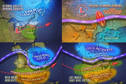
2. WHEN WILL WARM WEATHER ARRIVE IN FORCE? The Northeast has to endure two more coastal-type storms before the warm weather can really take over. This is the much-anticipated "pattern shift" that's been explained on this site for a few weeks now. It will take a series of large storms to reset the atmospheric imbalances caused by the negative NAO and Greenland/Canada High pressure block. The first storm comes out of the southwest on Wednesday, as shown on the graphics above, heads for the East Coast, bombs out and delivers some wrap-around snow to mainly higher elevations. The second system will take a more coastal track, from the Gulf up to the Mid-Atlantic over Easter weekend. Following this storm, I expect the Polar Vortex to retreat, taking the cold air with it and allowing the Sub-tropical Atlantic ridge (the pre-Bermuda High) to begin influencing the eastern third of the country by the first week of April.
SPRING SPORTS WEATHER FOR THE WEEK AHEAD
MONDAY-TUESDAY: Dry and seasonal temperatures in the 50's through the Northeast. Some wind will help dry fields from Sunday's precip.
WEDNESDAY: In VA, MD and PA...Rain arriving from a storm moving toward the Mid-Atlantic. The rain will arrive before afternoon practice begins and continue through the evening, but clearing overnight. Later in the day, snow and rain mixed is likely along the PA/NY line and into southern New England including the Boston Metro area. A low risk for thunderstorms or lightning.
THURSDAY-FRIDAY: Clearing but still seasonal with temperatures in the low to mid 50's south of NYC, and in the 40's in New England. Fields will be wet from the Wednesday precip.
LOOKING AHEAD TO EASTER SUNDAY: There is a "Wet and Muddy Easter Sunday Dress Alert", as the potential still exists for a rainy coastal storm to arrive Saturday night into Sunday morning.