
This weekly breakdown is for the Northeast from DC north to Boston. "South" or "S" means from the PA line south to the DC area. "North" or "N" means from the PA line/Phila area north to Boston.
MONDAY: WARM EARLY, BREEZY LATER, SHOWERS IN EVENING. The second in a series of clippers will cut through the Great Lakes, sending welcome and warm southwest winds ahead of the cold front. Temperatures may actually reach 65 in Washington, and crack 60 in Baltimore, but as you would expect, warming is muted farther north due to a refreshed snowpack. New York will flirt with 50 and Boston not getting out of the mid 40's. Still this is a nice respite from a rude March thus far. Later in the evening, the cold front sweeps east and ushers in rain with an isolated thunderstorm along the coast.
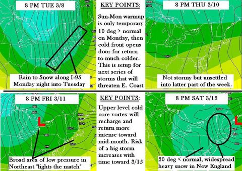
TUESDAY: MUCH COLDER WITH RAIN/SNOW MIXED SOUTH, SNOW SHOWERS NORTH. With ground temperatures higher due to the Sunday-Monday warmup, any precip in PA and MD that falls behind the cold front could be as snow, but will not survive upon reaching the ground. From NYC northward it is a different story, as accumulating snow is possible after the Low lifts NE, with the ever-present "Ocean Effect" adding to Boston's record winter snow totals of 78" Boston NWS indicates "Heavy Snow" is on tap Tuesday night for a brief period as some backlash occurs while the storm lifts into the Canadian maritimes.
WEDNESDAY: SNOW LINGERS IN THE NORTH, COLD AND WINDY SOUTH. This is the important transition day as a portion of the polar vortex begins another dip southeastward behind the clipper. Stiff north to northwest winds will return the Northeast to a 15 degree below normal temperature regime. Normal high in Baltimore would be 53, but will actually be 38. Wind chill in the upper 20's. Boston by contrast has an overnight low in the teens, and the high not cracking 30!
THURSDAY: UNSETTLED AS MATCH IS LIT FOR COASTAL STORM DEVELOPMENT. The next clipper coming from central Canada may link up with moisture and energy coming out of the U.S. Southwest. A broad area of low pressure over the Northeast provides the gasoline in which the match will light if there is phasing of the northern and southern jet streams over this area. Given the cold upper level environment, this could lead to a rapidly intensifying coastal snowstorm by Thursday night-early Friday morning as depicted on the maps below. This storm would have most of it's impact felt from Eastern PA-New Jersey northward to Maine from Thursday into Friday. I think that computer models are having a hard time resolving some of the variability in pressures due to the influence and behavior of the nearby polar vortex, which is why you see your local forecasts changing so much day to day.
FRIDAY: SNOW SHOWERS SOUTH, INTENSIFYING STORM MAY DELIVER HEAVY SNOW AND WIND NORTH. As shown on the European model map below, indications are that a strong coastal storm will affect the northern I-95 corridor, with strong winds and considerable backlash snow filtering possibly as far south as Philadelphia. From Southern New England into eastern New York and most of Maine, this will be another significant coast and inland snowstorm that could deliver 12 or more inches of snow if the elements come together as outlined here. However this is a preliminary look at what is possible, not an outright forecast.
MSA WEATHER: I believe there is little to no risk of weather interrupting this week's rescheduled Maryland State Assessments. Any snow/rain mixed on Tuesday is not going to impede travel. The possibility remains of some snow Thursday night into Friday that could cause a delay Friday morning.
The period starting Tuesday and ending around St. Patrick's Day is going to be replete with storms and cold weather, making you wonder if perhaps we have simply have the calendar months out of sequence. The welcome warmth of Sunday and Monday is going to be short lived, and by Wednesday morning some parts of the Northeast will be digging out from more snow, with rumors of even MORE snow coming after that. And after that? More snow. What about after that? Uhhh....more snow. Call it the winter that never ends, which may challenge even the more die-hard powderhound into crying uncle and waving the GREEN spring-a-ling flag. Some computer models have projected widespread snow to be on the ground even by the 21st. The "Great Disturbance in the Force" is any number of things...the Polar Vortex in SE Canada, the upper level low in the U.S. Southwest, the fact that we have clipper systems lined up clear out to the Gulf of Alaska. This is where March Madness gets its name, as there are a lot of factors in play which could easily consolidate into a great big storm on the East Coast with very little notice.
EXPLAINING THE COMPUTER MODELS
The map posted above is the European Model's version of the week ahead as of 12 Noon eastern time today. You have probably noticed the whip-sawing going on with your local forecast on The Weather Channel today. This is because most TWC local forecasts are tied to NOAA's Global Forecast System, the GFS. This computer model completes a "run" or analysis of observation data and prints out a forecast every 6 hours. There are actually 12 different computer models, called the "ensemble members" each of which make their own individual analysis. The output of these 12 members is blended into the GFS operational model, which is what I view when making my analysis. Sometimes the computer interprets the data differently, and thus prints a different outcome with each run until it resolves a variety of data anomalies and begins to present consistency from "run to run." That is when you notice the percent of probability of precipitation increase for a specific time period. So if you get annoyed with a situation like today, when your local forecast just blowing all over the place, it means the GFS is having a hard time trying to come to an agreement on the timing and placement of the next set of weather events.
HOW STORMS TEMPORARY INFLUENCE LOCAL CLIMATE
Our last big storm from Monday the 28th pumped heat northeast into the combined double barrel air flow of Labrador Low and Azores High near Greenland. This warm air enhances both systems, creating a continous stream of air flow into far northeast Canada. When this warm air intrudes into higher latitudes, it has the logical effect of redirecting the polar vortex usually located much farther north down into in SE Canada or even over the Northeast US. When that happens, the vortex often gets "locked in" as shown by the Accuweather graphics in the previous post. This is why we have observed Negative NAO values as low as they have been in the past 50 years. As shown on my graphics, the PNA is already heading for the stratosphere, and forecasters at HPC as well as those from Baltimore to Boston are becoming noticeably concerned in their discussions that the -NAO and +PNA setup cannot go on much longer without a major phasing event on the East Coast.
DOWNSTREAM CONSEQUENCES. Each subsequent Low pressure system which passes on by uses it’s counterclockwise motion to enhance the double barrel effect which puts increasing pressure on the 500 mb Polar Vortex swirling about. Meanwhile a strong west coast ridge forces the split jet stream to ridge up over the Rockies and Canadian Coast Range and into far northwestern Canada. A Low pressure system off the California coast, and a sharply digging trough in the Gulf of Alaska helps lock this pattern in place as these two work in conjunction with a persistent high over the Rockies to continue directing the Pacific Polar Jet northeast. Any cold air lurking way up there in the Northwest Territories can also be tapped, as well as create the setup necessary to even have "cross polar flow" from Siberia. The polar jet then comes charging southeast across Canada, approaches the vortex in Quebec, and that continues to direct the jet south and underneath it...right across the Northeast U.S. This setup will continue to rule our weather for at least the next 7-10 days if not longer.
4. WHAT ARE EARLY INDICATIONS FOR SPRING BREAK?
This over-abundance of cold which should have been spent in December, January and February is now being worked out of the system. I would not expect a consistent return to normal temperatures until at least the weekend AFTER St. Patty’s Day. But I do think March will follow it’s traditional route… in like a lion, out like a lamb. It is not impossible to see much-above normal temperatures by Easter or even a few days prior to it. I believe many of us in the Northeast will see 70 F by then, and even 80 F before the month is out.
The way I see this pattern breaking by month's end is actually how it started. I believe the NAO is going to do itself in. As more and more systems get pushed southeast by the vortex, this inadvertently sends High pressure southeast as well. It is the Highs which can have the longest lasting effect, as once one gets parked in the Gulf of Mexico such as in what is happening right now...it tends to pump heat northeast. Although the cold gets reinforced by the strong vortex, the clash between cold and warm enhances. Another high is sent south or southeast behind a clipper, that high lingers in the Gulf a few days. Eventually we reach a point where the upper level low in the Southwest and a Gulf High have the combined effect of lifting the northwest flow out of the midwest. I can see this would put pressure on the vortex to lift northeast, especially if the NAO begins trending toward neutral. The last straw is if there is a brief letup in the storm parade. That enables the southern systems to overwhelm the pattern with southwest winds. When that happens, we will see a rapid return to spring and temperatures in the 70's throughout the Northeast, and probably by month's end.
It has happened before, and this March I believe will go to the extremes for both sides of the aisle. As for the rest of spring and into summer, a overly cold March would argue for a warmer April, a cooler May, and a warmer June according to the theory I use for how the months see-saw the variables until temperature anomalies balance out.
ABOUT THE GRAPHICS: I have learned that the graphics program I use is having programming problems and the company will hopefully fix this soon. It is unnerving not be able to show you some of the evidence in a graphical sense, but I trust you will be patient.