
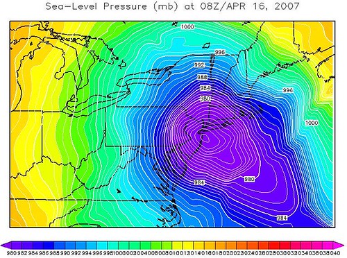
Now that was taxing...unofficially a barometric low of 969 millibars, or the rough equivalent of a Category 1 Hurricane / strong Tropical Storm. With high wind warnings posted throughout the Mid-Atlantic and Northeast, I wonder if some schools which have not closed or delayed from rain may do so because of wind. Hold a firm grip on that steering wheel.

PRELIMINARY EXTENDED FORECAST DISCUSSION
HYDROMETEOROLOGICAL PREDICTION CENTER - CAMP SPRINGS MD - 953 AM THU APR 12 2007 VALID 12Z MON APR 16 2007 - 12Z THU APR 19 2007
...INTENSE STORM FOR EAST COAST SUNDAY INTO MID WEEK...
(MODEL DISCUSSION CUT FOR NOW... WILL POST TOMORROW WITH EDITS)
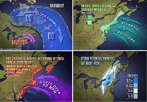
....EAST...MODERATE TO HEAVY RAINS WILL SPREAD E AND NEWD SUNDAY FROM THE OH VALLEY AND ACROSS THE MID AND S ATLC REGIONS AS LOW PRESSURE MOVES TO THE NC COAST. DEEPENING LOW SUNDAY WILL BRING GALE FORCE SRLY WINDS ALONG THE S ATLC COAST SUNDAY WITH INCREASING NE GALE FORCEWINDS INTO THE MID ATLC. THE LOW WILL BE DEEPENING OFF MID ATLC COASTAL WATERS AND MOVE INTO THE NY BIGHT BRINGING GALE TO STORMFORCE E/NE WINDS INTO NEW ENG/LONG ISLAND WATERS SUNDAY NIGHT INTO MON AND TUES. ABOVE NORMAL SPRING TIDES ASSOCIATED WITH A NEW MOONPHASE / HIGH WINDS AND COASTAL FLOODING ALONG WITH VERY HEAVY TO EXCESSIVE RAIN CAN BE EXPECTED WITH THIS STORM.
INLAND....PCPN TYPE WILL BECOME MORE COMPLICATED AS CONDITIONS SFC AND ALOFT WILL BE COLD ENOUGH FOR SNOW ACROSS INTERIOR PORTIONS OFNEW ENG/NY/PA AND POSSIBLY SWD DOWN THE CENTRAL APPLCHNS. HEAVY SNOW THREAT. HIGH CONFIDENCE FORECAST AND A POTENTIAL HISTORIC EVENT.
SOUTHWARD....THE DEEP STORM WILL BRING STRONG OFFSHORE W-NW WINDS SUNDAY NIGHT THRU MON AND CONTG TUESDAY AND KEEPING UP NW FLOW POSSIBLY INTO THURSDAY IN THE MID ATLC REGION. PROLONGED OFF SHORE FLOW LIABLE TO BRING WELL BELOW NORMAL TIDES CHES BAY/DEL BAY WITHA THREAT OF SOME SOUNDSIDE TIDAL FLOODING NC OUTER BANKS. THIS EVENT HAS SIMILARITY TO EARLY APRIL 1975 BLOWOUT EVENT. THIS AFFECTING SHIPPING IN DEL/CHES BAY HARBORS. A HIGH CONFIDENCE FORECAST. POTENTIALLY HISTORIC EVENT.
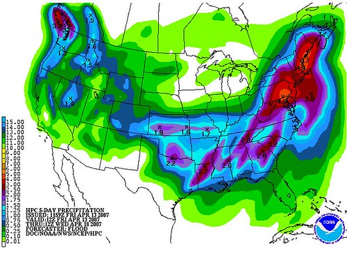
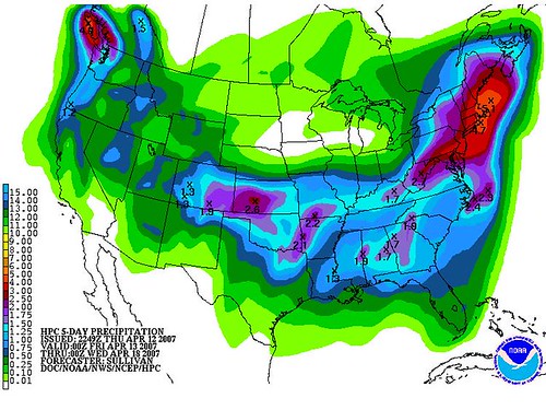
PROJECTED PRECIPITATION FOR THE PERIOD FRIDAY 4/13 TO WEDNESDAY 4/18:
IF YOU ARE READING THIS BY EMAIL...UPDATES WILL BE POSTED TWICE DAILY STARTING FRIDAY TO SUNDAY. Carefully consider your weekend travel plans if you are going to be along the coast or in the interior and en route back home this coming Sunday.