
UNCERTAINTY CERTAINLY WON FOR SOME
WED 2/13 7:15 AM: That was quite a not so "n-ice" surprise. As all of us in areas affected by ice have discovered, quite possibly the most miserable conditions I think are when you have a glaze of ice with water on top. What could be more grueling early in the morning than to scrap ice off your vehicle in pouring rain? That sure was a blast. But thankfully nearly all area schools provided extra time to pull it together this morning, except of course for Anne "What-in-the-heck-is-an-Ice-Storm-Warning?" Arundel County. If you have time, consider letting us know in the comments how your commute turned out, I'm curious to know just how slippery if was on side streets and the like. As for this evening's snow burst, uncertainty continues to rule the future as some refreezing of standing water seems likely, followed by a dusting of snow on top. I could see this turning into another round of delays Thursday morning.
TUE 2/12 10:00 pm: The Ice Storm Warning will be in effect until 7AM Wednesday, and there is potential for .25" to .50" of ice accretion on untreated surfaces. Even if temperatures warm above 32, school districts have to make the call at 5 AM and conditions are likely to be as bad as they are currently. I've reviewed regional temperatures, and the surface and boundary layer cold air seems well entrenched.
NOTE: Comments are all the way at the bottom of next post.
The extent of this Ice Storm Warning is a telling indicator that everyone, from the pros to the amateurs, underestimated the staying power of low level cold air. Almost inexplicably so, the warm air aloft has not been able to mix to surface levels as quickly as everyone believed it would. Almost as if the weather remembered what it was doing a year ago today (ice storm, ahem) and just pulled out those old programs and ran them again.
WHAT DOES THIS MEAN FOR SCHOOLS WEDNESDAY? I'm going to go out on a limb here and say the range of uncertainty is too large to ignore. Think about how quickly this surprised us all. Now let's consider Wednesday morning. Suppose your county roads have improved enough to allow for smooth traffic, but sidewalks and parking lots are still ice covered. Perhaps a delay would be the best route, give 2 more hours for air temperatures to warm enough that melting will take care of the problem for you. However, uncertainty calls that decision into question because a second storm system developing Wednesday is likely to turn any remaining precipitation back over to snow. You'd be in the very unforgiving position of having called a delay, followed by an early dismissal. The NWS has already hinted in discussions that another advisory may be needed starting tomorrow afternoon. If you throw in the potential for power outages, roads and bus routes blocked due to downed trees and branches, and slick conditions hampering road crews the opporunity to clear those areas...
...thus, I don't think it is wishcasting to project the following...
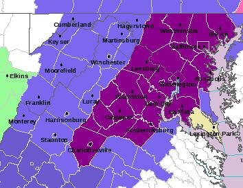
CLOSED: Baltimore City and County, Anne Arundel, Howard, Carroll, Frederick, Harford, Montgomery, Loudon/Northern Virginia, Fairfax
2 HOUR DELAY: Cecil, Prince Georges, DC Schools, Eastern Shore Schools
Let me know what you think in the comments, make sure you vote (in my poll) since it's still the Potomac Primary, and include your observations especially status of ice on your powerlines. Most of all, everyone be safe, I don't want to see your name next to "Breaking News: Weather enthusiast electrocuted while taking pictures in ice storm."
"BUT WHEN WILL IT BE...AND HOW WILL I KNOW ?"
Michael W. Smith: "Somebody Love Me"
-from the 1995 Album Change Your World
If the question is: "When will Maryland observe the next plowable snowfall?"
The answer: not before February 16 for the I-95 corridor, with the first chance over President's Weekend, followed by another opportunity between the 22nd and 28th.
TUE 2/12 INSERT: The latest expansion of the NWS Winter Weather Advisory may raise hopes of school delays on Wednesday, but that probability will not be known until 5AM tomorrow when we see what temperatures end up...whether they rise overnight or not. Regardless of the outcome, I'm sure the uncertainty will prompt many of you to spend the evening speculating on it. Rest assured, I'll be right there with you, speculating away myself.
How will we know: Once the North Atlantic Oscillation (NAO) turns negative AND the Pacific-North American Index (PNA) turns positive, there is an opportunity for the right combination of air masses and many other factors to deliver a traditional mid- to late-February storm. However as you know a lot has to happen in the right order. One promising sign that winter will strike back in the Eastern U.S. is that interior temperatures in Alaska of late have been near -70 F. While it may seem a real stretch to connect remote Alaskan cold to a mid-Atlantic snowstorm, it is not in dispute that this cold air will make it's way south eventually.
The main culprit behind such a lack-luster winter has been the extremely strong La Nina, with water temperatures in the Equatorial Pacific running 2 or more degrees below normal C across large areas. This influences the development of a persistent high in the northern Pacific. The end result creates an overall unfavorable environment on the U.S. East Coast for big and frequent snowstorms like was seen in the winter of 2002-03 when a weak El Nino was observed instead. I'll post some graphics of these two ideas, because the differences in water temperature anomalies between this winter and 02-03 are quite revealing, and help explain a lot behind what drives certain types of winters. In conclusion, I do believe the Mid-Atlantic will see a 6" snow event sometime between February 20 and March 5, but beyond that the chances of a good snow will all but disappear as increasing sun angle begins to influence our regional climate once again.