
VALENTINE'S DAY MASSACRE, THE SEQUEL?
Well, a year ago today, those of you in the Mid-Atlantic were fighting a massive ice storm that would eventually grip the entire Northeast over 3 days. Many schools dismissed 2-3 hours early, had the 14th off followed by a delay on the 15th. Are we set for a repeat? Consider the factors stacking up for tomorrow:
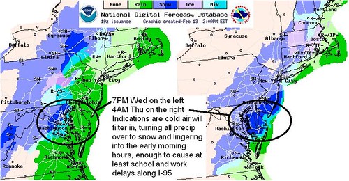
1. The NWS Digital Forecast Database above indicates all liquid precip will change back to snow or sleet overnight as sub-freezing temperatures return. While intermittent overall, this will make for slippery travel conditions throughout the night.
2. With dewpoints remaining high and plenty of moisture remaining on the surface, it is likely the Mid-Atlantic region will experience significant re-icing of roads leading up to the morning commute.
3. A developing low in the Carolinas will begin to pull cold air south, already evidenced by winds backing north and northwest. This secondary Low is going to inject moisture pulled from the ocean and direct it over central and eastern Maryland, just as the cold air arrives.
4. The result may be several hours of snow bursts late tonight and early tomorrow morning, with "banding" setting up on the western edge of the precip shield as the secondary Low moves northeast. NWS is going conservative, with snow amounts up to 1/2 inch, while Justin Berk of ABC2 News is alluding to the potential for up to 2" and possibly more if we see the banding develop as he indicated. Read over this Special Weather Statement in which the NWS outlines their concerns for what is to come over the next 12 hours for the DC-Baltimore region and Coastal Mid-Atlantic in general.
This will definitely be another "Nowcast" storm so I suggest you bookmark your favorite regional radar, and keep an eye on surface temperatures. My early call for Thursday schools is simple: Widespread 2 hour delays, with careful re-evaluation at 6:45 AM. If snow bands are continuing to redevelop and have overspread the area farther west than anticipated, it is even possible some districts in central and eastern Maryland will be forced to close. The other possibility is that the secondary Low might veer farther east and take the precip with it, shutting off any real chance for snow west of the Bay. Proof of that outcome will be a big dry slot forming where we thought precip would be, if you see that, you're going in on time because the winds will help to dry roads and parking lots before temps dip below freezing. We shall watch what happens with great anticipation, and I hope you'll post your observations into the evening as we see what the players begin to do.