
Looking for snow in the near future?
As of December 8, all I can say is there soon may be...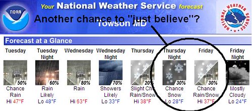
from Saturday, November 29:
SUNDAY STORM AND DECEMBER TRENDS
SAT AM UPDATE: I hope our tranquil Thanksgiving was enjoyable for you and your family, and gave you time to get "tanned, rested and ready" by Sunday, as we are heading full force into this season's first region-wide winter storm. However, coastal dwellers in the I-95 corridor will have to live vicariously through their interior Pennsylvania counterparts this time. This is yet another repeat of the storm dynamic the Northeast has had over the past 2 years: shallow fingers of cold surface air lodged in valleys over-ridden by warm moist air aloft. From Washington to Philadelphia and their metro regions, the cold layer is thin and will be scoured more quickly, turning a brief Sunday morning snowfall over to rain. The "kitchen sink" region will setup in the 219/220/99 corridor in western and central Pennsylvania from Johnstown to Altoona to State College. This area will see precip begin by dawn as light snow, and progress through the morning to sleet and possibly freezing rain depending on surface temperatures. North and west of this area should see mostly snow, but amounts will be limited to less than 4 inches until return flow in the storm's wake restarts the lake effect machine on Monday.
For the remainder of the Mid-Atlantic, east of I-81, morning snow mixed with sleet will prevent significant accumulation, but be enough to make roads challenging in the mid and late morning. Thus, if you are traveling Sunday, as I will be, my suggestion is to get on the road soon after sunrise when the precip will be light. I do not advise waiting to leave until you see a changeover to, as by then you'll have to negotiate a lot more slushy, slippery conditions and the bulk of holiday travelers returning home.
Passage of the primary low into western Pennsylvania, and the coastal low through Del-Mar-Va will change all precip over to rain by Sunday night - squashing any possibility of Maryland schools being closed on Monday, although some interior PA districts may have delays due to refreezing Sunday night.
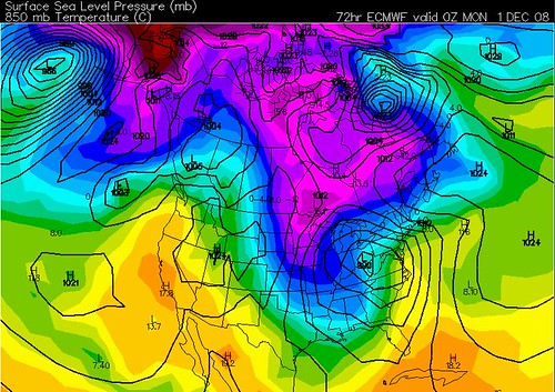
This current European model projection for 7PM Sunday night supports my adage for these types of storms: "The primary low stays stronger longer." A 990mb low in Ohio will track across Pennsylvania, enhanced by upper level short-wave energy while a weaker secondary low moves through the southeast. Also to note is the lack of a surface high to resupply with cold air. In this scenario, no high and the separation between the two lows will prevent this system from cranking into a widespread coastal snowstorm.
I believe the setup of this storm finally reveals the true indications for December's weather patterns: the deep 850 mb trough in the midwest (pointing to a negative NAO), the Pacific/western ridge (leading to a positive PNA), and a new reserve of cold air, while not extreme, is beginning to reload in northern Canada. The next section focuses on my forecast and analysis for December into January, and over this weekend will be adding graphics and links to support the discussion.