
Hey weather: Don't be a turkey!
AN EARLY LOOK AT THANKSGIVING WEEK CONDITIONS
UPDATED 11/22/2014 - If long range projections are on target, it appears Mother Nature got our memo from 9/25 when we anticipated that a "White Thanksgiving was more likely this year than a White Christmas." The European and US Global Forecast System model printouts, though just at the 120-hour mark, are leaning toward a more snowy result for the mid-Atlantic Wednesday night into Thanksgiving Day. With this event potentially impacting the busiest travel period of the year, we are preparing an overview of the possible hazards, timing and intensity for posting here on Sunday.
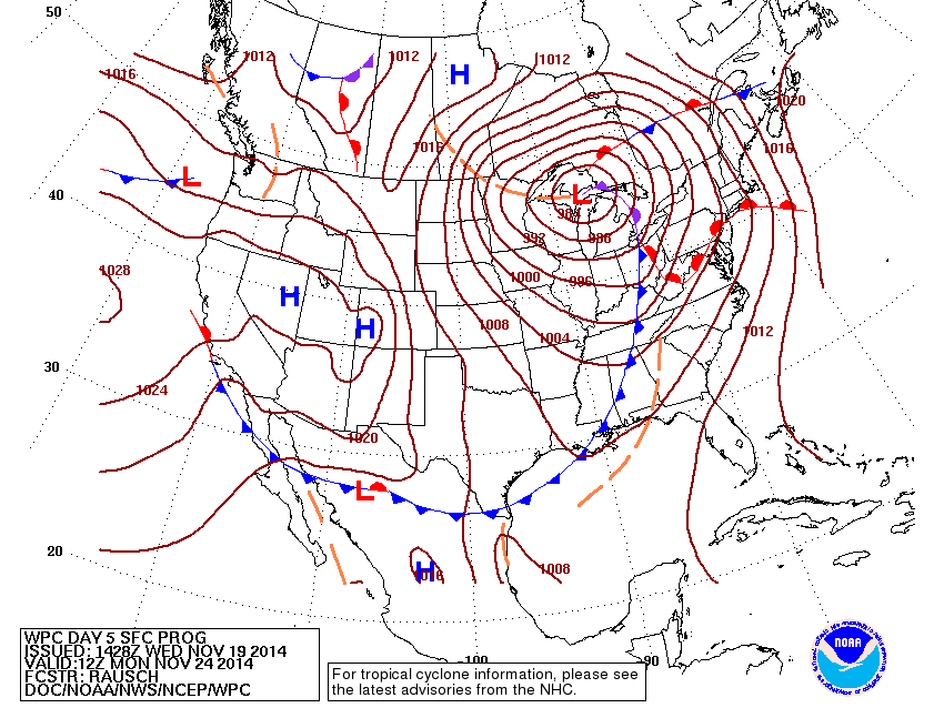 |
| NOAA SURFACE MAP PROJECTION FOR NEXT MON 11/25 AS OF WED 11/19. |
11/19/2014 - We know it's coming on quickly, there's nothing anyone can do about it, and there are some who wish it would never happen.
It's not the raucous Midwest-Great Lakes storm to roar through the heartland next week...
Rather, it is the sometimes dreaded Thanksgiving week travel and the shopping frenzy to follow -- that plunges us all headlong into a spin cycle of insanity. Toss in a "little weather" to the airline adventure and whoop! There it is: Harried parents and woesome children at long ticket counter lines... and so on.
But thanks to taxpayer-funded technology, we have access to this really cool technology from the US Department of Commerce that actually SHOWS, like, a glimpse of what things could be like next week as the holiday travel season launches forth. This way, it's not a mystery to anyone:
- MONDAY: A vigorous storm system will develop in the southern plains and head for the Great Lakes. On east side of the storm, temperatures Mon-Tue in the Eastern U.S. will begin rebounding to seasonal levels. On the west side of the storm, as noted by the cold front above, conditions will be -- you guessed it -- STORMY! Strong winds, heavy rain and then potentially heavy snow.
- TUESDAY: We already hear Airport Operators saying, "Can we just get that thing outta here before Wednesday?" Well try, my friends, we'll try. However, it is reasonable to expect flight delays may begin Tuesday and spread into Wednesday because of the front sweeping across the Eastern states. Places that face potential travel disruptions may include the I-95 corridor from Richmond to New York as a series of Lows could develop and move north along the cold front. Indications point to this being more of a "wet" day than a "white" one, as temperatures should stay above freezing. We'll monitor closely of course as the day approaches.
- WEDNESDAY: Arrival of the dreaded big travel day. Early interpretation from NOAA's Day 7 map, while still quite distant in weather time concerns, suggests the hope of travelers may pan out: High pressure looks to reestablish behind the front in the Eastern US, stabilizing the pattern from storminess for Wed into Thanksgiving Day.
Until then, think ahead to how you would alter your plans for travel on Wed 11/26 IF you had to, unless the weather decides to cut us a break this year and not be a turkey after all.
Forecaster Foot & the Long Range Team