
The Return of Isabel ?

11:00 AM 9/30 - As of the latest NHC advisory, Joaquin's projected path continues to shift west, and the cone of uncertainty / potential areas affected would encompass the entire Northeast megalopolis from Norfolk-Richmond to southern New England.
Our team is preparing decision graphics for posting this afternoon, that we hope readers will find useful as we recommend taking advantage of today's relatively low rain environment to initiate prudent preparatory actions for your family and property.
Our team is preparing decision graphics for posting this afternoon, that we hope readers will find useful as we recommend taking advantage of today's relatively low rain environment to initiate prudent preparatory actions for your family and property.
- AS OF 5 AM, THE NHC ADVISORY INCREASED JOAQUIN TO HURRICANE STATUS, WITH A NOTABLE WESTWARD SHIFT IN THE TRACK, BRINGING THE STORM DANGEROUSLY CLOSE TO THE DELMARVA AND SOUTHERN CHESAPEAKE.
- INTERESTS ALONG THE CHESAPEAKE BAY, INCLUDING VA, MD AND BEACHES ARE RECOMMENDED TO TAKE EARLY ACTION PRIOR TO THE NEXT ROUND HEAVY RAIN THURSDAY INTO SATURDAY, WHICH MAY PRODUCE AN ADDITIONAL 6-8" ACROSS THE ENTIRE NORTHEAST CORRIDOR.
- WE REMAIN ON RECORD TO SAY UNLESS DRASTIC CHANGES OCCUR IN TODAY'S COMPUTER MODELS, THE MARYLAND AND THE ENTIRE MID-ATLANTIC REGION COULD EXPERIENCE IMPACTS THAT EXCEED ISABEL IN 2003, IRENE IN 2011, SANDY AND HAZEL IN 1954.

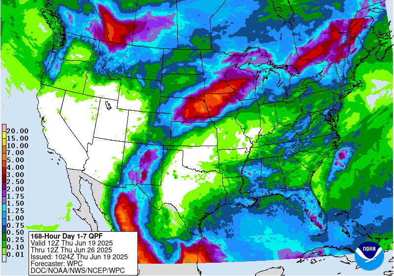
NOAA 7-day Rainfall Projections
Additional 8-10" is likely for areas shown in orange along the East coast.

9:00 PM 9/29 - As our team continues monitoring the progress of Tropical Storm Joaquin, today's run of computer models is getting more extreme with each passing hour. Some projections we've seen internally for this storm are beyond insane and would, quite literally, be a disaster that by some interpretations could exceed Isabel (2003, shown left) Irene and Sandy were these to come true.
Those who know us well and have been on this page a while understand we do not not hang our hat on just one model map and say, "there's our forecast, done!" We prefer to be honest and upfront about forecast uncertainty, especially when accounting for erratic tracks of tropical systems 1,000+ miles away. So, herein lies the challenges we all face with this storm:
1) The rain falling now will be a MINIMUM of 3-6" now to Thursday, with another 3-4" on top of that this weekend, even if Joaquin never touches land. These rainfall forecasts may exceed what Sandy did in 2012. Areas of southwestern Virginia are already seeing major flooding and washed out bridges, before a tropical system arrives. Consider this rainfall forecast from NOAA for the next 7 days. That orange is 8-9" of rain. Have you ever seen a map with that much rain forecasted from North Carolina to Maine?
2) The National Hurricane Center projects an 85-mph hurricane a few hundred miles off the VA coast Sunday morning, but they make clear 3-5 day track forecasts can be off by up to 300 nautical miles. It is the nature of uncertainty with large disturbances that do not follow exact procedures like humans or machines. That means places like Crisfield, MD, Ocean City, MD - the Delaware Beaches or Virginia Beach may LOOK like they're going to escape, when in reality, they might be in the bullseye. We also think the NHC will unfortunately have to shift the track dramatically west, unless all the computer models are to be discarded.

3) Just 5 days remain until ONE of these disturbing model solutions we are following becomes the real McCoy and makes its move, or not, on the coast. Keep in mind the majority of models point to some type of Mid-Atlantic landfall that could produce Irene-like wind and a Sandy/Isabel type surge.
- Given the potential severity of a new high impact tropical system that *could* be only 5 days away, we are compelled to notify you of this possibility.
- The map below shows a 978 mb Category 2 hurricane making landfall near the Outer Banks, then tracking very similar to Isabel - into southern Virginia.
- Our confidence for these scenarios is not high, but the uncertainty underpinning the entire forecast is very high, hence the urgency to make clear the potential risks.

Forecasters Foot, Troy A., Connor M., Jason M., Mike N., Nikki B., Joe F. and Advisor Forrest