
Big Kahuna To Blizzard The Northeast


Current Regional Radar

National Radar

"Something Wicked This Way Comes..."
-Macbeth, Act 4, Scene 1
UPDATE FROM 3:00 PM SUN 3/12

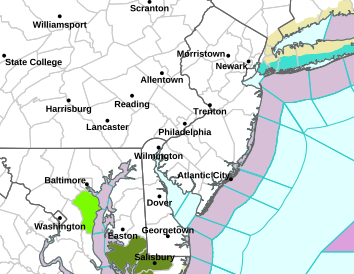
- BLIZZARD WARNINGS EXPANDED (RED) TO INCLUDE PHILADELPHIA METRO, EASTERN PA & NORTHERN NEW JERSEY FOR 18-24"
- WINTER STORM WARNINGS (PINK) IN EFFECT THIS EVENING THROUGH TUESDAY AFTERNOON. Check your local NWS office for latest official details on current statements. Click Advisory map -->
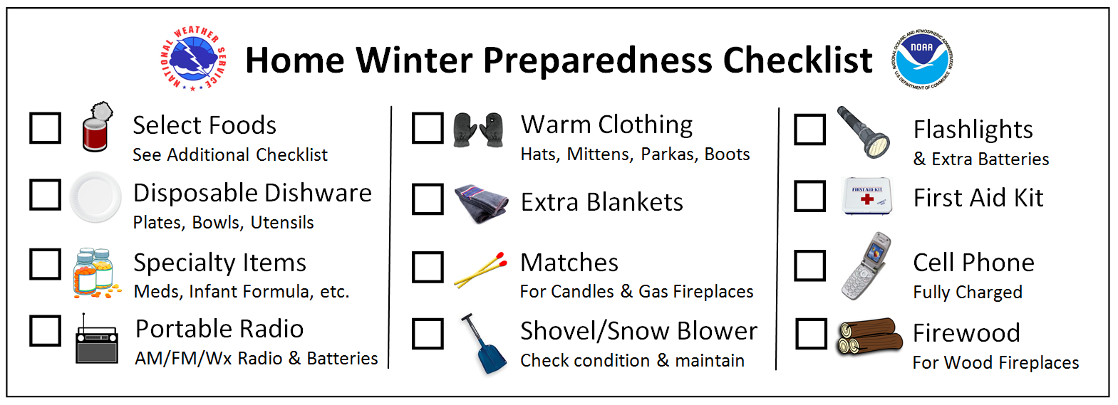
- HIGH IMPACT EVENT with multi-hazards. Please refer below to Storm Information Graphic and NOAA Winter Weather Safety graphics.
- POST-STORM: Sub 20F temps & widespread refreezing of snow melt each morning.


Current Regional Radar
National Radar
"Something Wicked This Way Comes..."
-Macbeth, Act 4, Scene 1
UPDATE FROM 3:00 PM SUN 3/12

- HIGH IMPACT MAJOR WINTER STORM WITH HIGH ACCUMULATIONS FROM METRO AREAS OF DC-BALTIMORE-PHILADELPHIA-NYC-BOSTON.
- WINTER STORM WATCHES & WARNINGS POSTED FOR MUCH OF THE CENTRAL & NORTHERN MID-ATLANTIC.
- BLIZZARD WATCHES & WARNINGS FOR NEW YORK CITY, LONG ISLAND TO BOSTON METRO
- SNOW ONSET BY MONDAY NIGHT, HEAVY INTO TUESDAY, 6" OR MORE LIKELY BY DAYBREAK IN AREAS COVERED BY WARNINGS.

SNOWFALL: The craziest heavy wet snow this region has seen in March since 1993. At least 6" area wide is projected from Washington DC north in the region between west of I-95 to I-270 at Frederick, then into southern and eastern PA. This includes the Baltimore-Harrisburg-Philadelphia metro areas.
Some areas may reach 12" by DAYBREAK Tuesday, where heavy snow bands setup. The Sterling NWS has said, "some location may see significantly higher accumulations" as posted in the latest Winter Storm Watch from last night.
INTENSITY: Thundersnow and Lightning like you've never seen.
- Over 1" of snow per hour will be common early Tuesday morning, and 3" an hour or higher is possible for areas near the Bay and where Atlantic moisture transport plows into embedded thunderstorms. 3"? How?
- When deep moisture transport from the Atlantic plows into a "Games of Thrones" wall of cold, it is forced rapidly upward not unlike convective thunderstorms. Result: Wildly intense thundersnow you've not heard in a long time.
- Liquid Projections of 2.0" or greater will enhance this effect, see below for maps.
- 3 days of subfreezing overnight temps to chill roads, and an overnight onset of snow with heaviest amounts coming between 10 PM and 8 AM
- 3 more days of very cold overnight lows in the teens. Result: Mid-Atlantic region ends up locked in an icebox until Friday morning.
- New York City to Long Island and coastal southern New England have a Blizzard Watch already, for sustained winds of 35 mph over at least 3 hours during the storm.
- For the Philadelphia-Baltimore-Washington area and westward to I-81 in central PA to northern VA, winds up to 25 mph will be widespread.
- Areas near the Bay will see near-blizzard conditions with winds gusting to 35 mph at times.
- See our Storm Impact Graphic below, this is a dangerous multi-hazard event including cold temperatures, heavy wet snow and strong winds which will down trees and power lines.
- High water content of the snow will make for difficult removal, so we advise frequent breaks and neighbors helping neighbors to prevent avoidable loss of life from shoveling.
- Emergency crews may not be able to restore your power as quickly as it went down, due to blocked, snow-covered roads and heavy wet composition of snow making removal difficult.
- If your area is prone to lose power, have alternate plans in place- either relocating where power exists or being able to stay warm with overnight temperatures in the teens.
SNOWFALL MAP: NWS EASTERN REGION

MARCH 2017 BIG KAHUNA INFO GRAPHIC

WINTER STORM SAFETY RESOURCES

Our wishes to all for safety and wise choices during this upcoming time of "Double double, toil and trouble" you weren't expecting to see as we close out this season that was at times, called Winter.