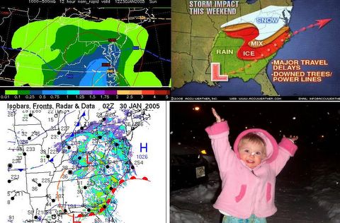
INSIDE US ALL IS A KID WHO LOVES SNOW
SATURDAY EVENING MINI-UPDATE:
Thanks to all for your comments, questions and observations. Our daughter is celebrating the snow with you, as that is a picture I have been waiting a long time to take...her with snow falling out of the sky. She has just begun to say small words, and would you be surprised that "SNOW" is one of the words she loves to say. I hope she'll have many more oppportunities to say it in the near future.
A couple observations before bedtime:
1. I think it is obvious from radar, the obs map, and Accuweather's graphics that this puppy is coming farther north. The heavy snow that many forecasters, including me, expected for south western Virginia may not materialize, and in reality, the area of heaviest accumulation may be shifting east and northeast.
2. I am concerned about the upper level Low (which I consider Storm 1A) in Kentucky. Paul Kocin on the Weather Channel says this system may come directly east, and redevelop off the coast. I have seen previous upper level systems activate snowfall in the Baltimore metro area, from tapping Bay moisture...basically "Bay Effect Snow" if there is such a thing. Sunday, Jan 5, 2003 is a prime example. An upper level feature came right across central/southern Maryland, and what was predicted to be flurries turned into 4 inches of snow. This system reached the coast, redeveloped somewhat, and wrap-around started, giving us another 1 inch. The punchline is that this extra inch began to fall at 5:00 AM, just as schools were deciding to open or not.
Baltimore County decided to close. Then at 7:00 AM, the snow stopped, sun came out and the day was fine! Do I think this will happen again? The dynamics are the same, there is certaintly plenty of moisture around. The main issue is if Storm 1B currently the Gulf will redevelop along the Carolina Coast or not.
3. North Carolina: In NC, what was thought to be heavy snow is turning out to be heavy ice. Temps have been a conundrum all day for forecasters. It is a simple fact this High meant business and we saw that going into this storm. I think the cold air damming down east side of the Appalachians was underestimated, as has been the moisture feed from the Atlantic. If you get any snow, it will lend to a lowering of temperatures, because this is called "evaporative cooling." As the moisture crystallizes into snow, this process takes heat OUT of the atmosphere, and as the snow falls, I like to say it "brings the temperature down with it." That would mean you are in for general right around 32 F tonight. If the coastal develops, I think it will capture cold air from up my way, and the wrap-around effect will send that cold air your way, potentially refreezing that slushy ice tomorrow night.
4. Next Week's Storm. A lot of variance in the models. The JMA (Japan Meteorological Agency Model) is predicting a hybrid nor'easter type thing, and the GFS is hinting at something as well. I will do a roundup on what models are saying and what I think they are telling us. If you want the total inside scoop on this for the moment, the Boston NWS Forecast Discussion has outlined the possibilities, which I will analyze in detail on Sunday. For now, it is becoming more clear that something bizarre is in the offing for the middle and latter part of next week for Southern New England.

