
HERE IT COMES...READY OR NOT
SATURDAY PICTURE SHOW ROUNDUP:
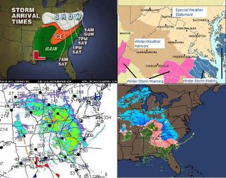
Freezing rain and sleet have held on tough overnight and into the morning throughout the Deep South as you can see from the radar. One quarter to three quarters inch ice accretion is expected. The big culprit is of course our large High which has refused to give up any ground, and is stronger and colder than expected, now parked over the northern Del-Mar-Va. This was clearly pointed out in my previous two posts as the reason why the storm might end up being stronger, more snowy, and come a few miles farther north than anticipated. Keep an eye on the 'Current Observations' map for a real-time look at where the storm is.
If you are new to the site, scroll to the post below for the forecast on this storm.
The NWS has advanced the onset of precipitation by a few hours or so in the DC-Baltimore regions, then backed off to late tonight again. The Philadelphia NWS has hoisted the Winter Storm Watch flag for parts of the Del-Mar-Va. Baltimore NWS keeps flipping back and forth between all snow and a mix, and alluded that amounts are a shade below "warning criteria." I believe these factors are an indication the storm is starting to show signs of creeping farther north than we anticipated.
I know to New Englanders and others used to a lot of snow that this seems a lot of fuss over less then 6 inches of snow for most areas. My issue is that this is a Gulf-Altantic coastal Low, so it has lots of time to tap lots of moisture. With that high drifting off the coast, is it possible the return flow shoves our storm a teensy bit more north and west? I think so. You can see from the Obs and Radar Map that this thing is going to town as the moisture makes it's way northeast. I make this storm a big deal because of my belief it has the potential to come farther north and cause a lot of problems for the Mid-Atlantic from DC north. I believe we also have the makings of the secondary Low forming off the South Carolina coast.
Lunchtime update: NAO has begun to trend back to more slightly negative as of today. I could just be overly enthusiastic because I love storms, but it is also a sign that this current storm may have a few surprises left in store for those of us south of the Mason-Dixon Line. The only changes I have made to the snowfall grades is to Richmond... it was 2 inches and I will raise that to 4 inches.
Big Warmup Update: TWC forecast for Baltimore on Friday was 47 two days ago. Now knocked down to 43. Humpf, wonder why that it.
Snowday Potential: I think a delay is likely for Baltimore-DC metro area schools Monday, especially if there is re-freezing. From Richmond northwest to Harrisonburg, south to Roanoke... NO SCHOOL Monday.
Crystal Ball Alert for next big storm: I will do a re-analysis of the big storm potential for next week. Folks, it is still on the table given the NAO and an active southern stream. I have convincing evidence and actual observations from atmospheric dynamics that Storm 2 is lurking in the near future (7-9 days) for the East Coast, despite whatever your local TV or internet news outlet may say. But I have family visiting today, and it is playtime with my daughter, who has been away for a week. I will post that analysis late this weekend...before school Monday.