
WHY NOT THREE BLIZZARDS?
Second of three major winter storms to grip East Coast late this weekend from South Carolina to New England...each storm will be more intense and widespread than it's predecessor. National Weather Service beginning to recognize atmospheric parallels to previous patterns which have led to crippling, immobilizing storms in the past. Accuweather already hinting at possible major storm, but computer models are all over the place as usual.
HOUSE-KEEPING AND SITE UPDATES
- I have added a variety of new links in this "calm before the storm" to help you understand the science behind the forecasts, if you wish.
- I have yet to complete the wrapup of Blizzard #1, and my new grading scheme. I will post that tomorrow along with my grades for snowfall totals across the Northeast. The overall storm forecast was a B- and I'll explain how I arrived at that so you can see it is fair statistical formula.
- Before I go back into giant megastorm mode, I thought it appropriate to re-introduce myself a little more to new viewers and discuss my background with weather so you know where I am coming from.
WINTER STORM WATCH FOR SOUTHEASTERN NEW ENGLAND TONIGHT
Another vigorous clipper (according to ABC 2 in Balto, is clipper #5 as of late) will swing through Pennsylvania today, bringing a light snow/light mix to the southern portions of I-95 from Philly on south. Central PA might pickup a couple quick inches due to lake effect, as will mountains of western PA near Seven Springs Resort. Reaching the Jersey coast, all eyes are on New England as it is believed this system may slow down some (have we learned our lesson?) and tap that readily available above normal Atlantic water. Thus a general swath of 1-4" looks likely from central and northern PA to north of NYC and into SE new England. Then late tonight as Atlantic moisture is tapped, some regeneration of the Low enhancement is expected along the coast, with a wraparound that can drop up to 4 inches in Boston and 6 inches along the Cape by early tomorrow morning.
For a few hours, it may look like Blizzard #1 was making a comeback, just like the quick bursts of snow we all saw Monday afternoon.
GRADING SNOWFALL FORECASTS. Please note in my new snowfall projections that I am now issuing a SINGLE number. The expectation is that the results will be 2 inches on either side of that number. So if I predict 4 inches for Logan Airport, and 3 inches fall, the score is a 75% and the grade a C. If the storm goes berzerkoid, and Boston gets 6 inches, that is 125% but still 25% off, so the grade is still a C.
ANALYSIS OF BLIZZARD # 2 FOR THIS WEEKEND
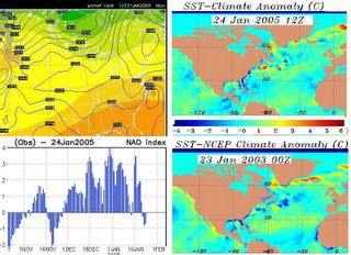
Explanation of maps above.
Panel 1, left top is the European for late Sunday night. It has changed somewhat recently, but has consistently advertised a fairly hefty system rolling up the east coast late Sunday. Notice the high PARKED IN THE WAY ahead of the storm. Same setup as notable Blizzards of the past, namely 83 and 03.
Panel 2 and 3 is the Global Sea Surface Temperature Anomalies for Jan 03 and Jan 04. Notice the extremely warm water (reds and oranges) off the Northeast Coast right now, as compared to Jan 03. Notice how the Gulf is a degree or so warmer now than it was 2 years ago at this time. This water temp variance will be critical in the next 3 weeks as it is pretty much the Quarterback of this game.
Panel 4 is the North Atlantic Oscillation, a measure of changes in atmospheric mass/air pressure between the Icelandic Low and the Azores High. When the "NAO" flips negative, the East Coast is more often than not, hammered with a big storm. WHEN THE NAO STAYS NEGATIVE FOR A LONG PERIOD OF 10 DAYS TO 2 WEEKS (as NOAA is forecasting it to do), then the East Coast is in for a period of successive storms and very cold weather.
So here's what to do this week...
1. IGNORE THE GFS (Global Forecast System). It has a history of supressing these storms too far south or sending them out to sea. How many NWS forecast offices said Blizzard #1 was not going to go north? Eh?
2. FORGET THE 'BIG WARMUP' that TV forecasters and everyone else is calling for this week. Some of the coldest air of the season is coming for Friday and Saturday. Why? Because the GFS has trouble incorporating the fresh snowpack influence on surface level temperatures. Your temps Thu-Fri-Sat will probably bust 10 degrees below what was originally forecasted on TWC and everywhere else. 50 degrees in Baltimore? Whatever. 45 in Boston? Let me know when that happens this week, cause it ain't gonna.
3. WATCH THE DANCING MODELS. No not that kind, geez. Get your mind out of the gutter. I mean how all the computer programs are going to waffle ALL OVER the place with this all week long, and it will drive all of us insane. You are going to see every forecast under the sun for this weekend all up and down the East Coast, from rain to partly cloudy to heavy snow to freezing rain and sleet to nothing. Then suddenly on Friday, presto! Major snowstorm and Special Weather Statements galore. You just watch what happens, we'll see how it ends up.
4. ACCUMULATION MANIA. I believe this storm will be a cross between Jan 22, 1987 and Feb 11, 1983. If you notice the QPF's for Day 4-5 on the links above, you'll see that what ever is coming out of the Gulf will be LOADED FOR BEAR. 3+ inches of liquid at kickoff.
Answering your comment questions
There is going to be a period of tremendous hedging by almost anyone in the forecast business about the eventual outcome of this storm. I especially enjoy watching the go-between of Justin Berk and Norm Lewis on Baltimore's ABC 2. Norm is the Chief Meteorologist on for the evening broadcasts and Justin is the early morning guy. Justin comes on Monday morning and says.. "Another coastal storm possible this weekend." Then Norm comes on Monday night and says, "Just some freezing rain, nothing big to be concerned about." Now Tuesday morning, Justin returns with a moderated "Coastal Storm Mix." Interesting to see what Norm does tonight. Once again, we have to issue a MARTY BASS alert for our Baltimore viewers, as he is going to have to make a call about this storm sometime, and it will be a tough one for him. Julee, Chip and Hereford friends, keep us posted on what Marty is up to.
So what is the reason behind everyone hedging versus me coming out with guns blazing?
NWS is hedging on this storm because they believe...
1. The cold High coming in behind this clipper is going to slide off the coast sooner than they expected, and the cold air will be retreating somewhat. That will create a southeasterly flow directing TOO MUCH warm moist air into the developing Carolina Low, resulting in more of a rain/snow/ice mix.
2. That kind of sloppy arrangement would cut down on accumulations, obviously. Coastal cities would see some snow, changing to sleet, then freezing rain and then rain.
I am not hedging on this storm because I believe...
1. Computer models are still underestimating the strength of the high coming Thursday and Friday. GFS projects that snowpack will diminish, thus moderating the high somewhat. Hey Philadelphia, you tell me by Thursday how much of that 13 inches melted away, okay?
2. This is going to be a southern stream intrusion into a cold Canadian high. Classic setup.
3. By Friday, there is another high very close by just above the lakes. Both highs will not be that much different in their pressures by Saturday. Has ANYONE considered the possibility that instead of being two distinct systems, they link and more cold air than was originally thought is able to bleed out in front of the storm? Is that a totally unreasonable idea? And if the storm develops as expected, who is to say the counter-clockwise motion is not able to tap cold air available in that second high?
4. Underestimated strength of high and lower than expected temperatures will allow for considerable cold air damming down east side of Appalachians. Many times before NWS has indicated that it is hard for the upper level warm air advection to scour out the surface level cold air. Cloud cover should be limited Saturday, allowing night time temps to plummet.
5. New England should consider themselves UNDER THE GUN because position of high on Sunday is going to slow forward motion of storm, enabling it to gather abundant moisture before the final assault. Impacts could range from a very wet, sloppy snowstorm with strong wind to a paralyzing ice storm if there is less cold air in place when moisture arrives. Imagine what would happen to all your roofs even if just several inches snow/rain/ice mix fell on top of the 18-38 inches already there? Thousands of roofs would collapse, ensuing a regional disaster. On the other hand, once the storm gets wound up with a fresh supply of cold air, what was forecasted to be several inches of wet snow becomes...1-2 feet of wind-whipped powder all over again.
SO YES VIRGINIA, ANOTHER MAJOR SNOWSTORM IS POSSIBLE AND YOU SHOULD BE READY.
Tuesday night, I will do a more specific day-by-day breakdown of how I think this will play out. In the meantime, you go get that snowblower, you'll be happy you did, and fill up about 3 of those red gas cans with the 32:1 gas oil mix. You are going to need them the rest of this winter.