
TWO ROADS DIVERGED IN A YELLOW WOOD... AND I TOOK
THE ONE LESS TRAVELED BY, AND THAT HAS MADE ALL
THE DIFFERENCE.
- Robert Frost, from "Stopping By A Woods On A Snowy Evening."
WARNING: Ultra long post. It has to be that way because I must lay the groundwork for the basis of this storm forecast. But if you don't care about the philosophy or the science, and just want the straight talk, then just scroll to the end, I won’t be offended.
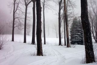
The picture above was taken at Seven Springs this past Saturday afternoon as I was skiing in beautiful fresh powder. Looking at this picture, I think to myself… here is a vast field of trees, with many different trails to take. All those trails at first lead to a variety of places, but as I continue along any particular trail, after a while, I reach two possibilities. One, the wrong trail leading me out of bounds and into thick woods. Or…Two, having skied these trails several times before, I have a fairly good sense about which one to take that will eventually connect with others, and ultimately take me to the bottom of the mountain, and my final destination.
But before I overwhelm you with intense scientific analysis, please consider my second analogy.
Earth’s climate and weather all follow a regular pattern. The pattern may not seem very discernible to us mere mortals at times, especially when it is in cycles of 60 or 120 day or 10 years or 200 years. But each weather pattern is an on going highly complex chemical formula, that continually repeats and resolves itself. Recognizing the pattern is more than just looking at the cover of the Da Vinci Code, and saying… “there’s that book!” and then reading the inside flap. To get a real sense of what author was trying to convey in cracking the “Code” you have to immerse yourself in the intricacies of the book and try to pull out some meaning that you and others can understand. Then, when someone asks you, “What’s that book about?” You can give them a reasonable explanation based on your understanding. Usually, when a lot of people read the same book, there are different opinions as to the meaning, but most everyone will come up with some kind of synopsis that is close to the main ideas. Rarely would you have someone give you a synopsis of a book that is totally out of synch with what everyone else read, or you would probably say… “Were you reading the same book that I did?”
And that’s what we have going on with our next big storm. Everyone is reading the same book (the forecast models), and most of the readers (forecasters), are coming up with pretty much the same synopsis of what the book is about (the weekend forecast). Everyone else around them has said, “Since you read the book already, I’ll just take your word for it, and not bother reading, saves me time. Besides, your analysis seems to fit with what everyone else is saying.” But you have read my synopsis of the book, and are thinking, "How is he coming up with that?"
Now relate these two analogies together, so you understand where I am going with this. I have skied for 15 or more years now, and visited a good number of resorts. I have gained an intuition about how trail network is laid out, that I can find my way back to the base lodge easily enough without getting lost. I can just take the standard trails I see everyone else skiing down, and that’ll get me back quickly, little effort. But part of the thrill of skiing is finding those interesting and little known trails, which are clearly marked on the map, but not as well traveled. Such as the picture above… glades, among my favorite type of trail. So I venture through the glades, and I think… “Gosh, this is so pretty here, I wonder why more people don’t come this way?”
And then it hits me… first, I don’t want them to come this way, because too many will spoil the pristine atmosphere at the moment. Second, they aren’t going to come this way regardless, because it looks too different and unfamiliar. It is “off the beaten path” maybe too dangerous, maybe too risky, not sure where it leads, how would I ever get back? That picture was middle of the day, and it appears that not too many people had gone that way since morning. But I took the one less traveled by, and that made all the difference, because I inadvertently found a new route back to the base lodge, one that no one else had skied yet, because it was all fresh powder underneath.
And that my friends, is what I also plan to do with this forecast. I will take the trail less traveled by, because I believe I have enough scientific basis on my side this time, and the confidence to veer away from the traditional routes. My hope is to explain to you the new trail I am taking in a way you'll understand, before everyone else finds it.
ANALYSIS FOR SECOND EAST COAST STORM LATE THIS WEEKEND
Now that you’ve survived the philosophy missive, let’s get on to the real deal.
PART I, TAKE A HAMMER TO THE GFS
(This is the NOAA’s flagship computer model, the Global Forecast System. While is an excellent tool, it is replete with significant errors which have led to debacle after debacle in the big storm arena.)
1. Frustration over wildly vacillating Accuweather 15-day forecasts is a waste of our valuable time because most of those forecasts are tied directly to the GFS database. I’m sure it’ll keep printing out 50 degrees for Boston until the day before the storm.
2. The GFS was the same computer model which consistently predicted that Hurricane Jeanne would GO OUT TO SEA and never hit Florida, let alone in the same place that Frances did. You what really happened.
3. In February 2003, the GFS was unable to initialize in it’s data runs the fact that a gargantuan Arctic high was going to park itself over the East Coast and block forward motion of an intensely moisture laden system coming out of the southwest and Gulf of Mexico. I saved the last Special Weather Statement issued by the Baltimore Washington NWS Office, before I left for the weekend and go to…. Where else? Seven Springs. Would you believe the NWS was still expecting a mix with and changeover to sleet and freezing rain in THAT storm? On Friday, 2/15…forecast highs were in the low 30’s for Sunday at Baltimore. The actual high? 18 F. What was going to be several inches of wet snow at my house (as indicated by the weather service ended up as 23.5 inches, and the rest you all experienced yourselves.
4. How quickly we forget. The GFS was the LAST model to come on board with Blizzard #1, as E.H. in Boston pointed out, and even then just 12 hours before onset of precip. And you’ll remember that’s when most of the NWS offices went berzerk with their Day After Tomorrow-type snowfall predictions. The GFS was consistently advertising that Blizzard #1 would head southeast and out to sea, not to affect New England at all. Did I not say that when we think it will not be as bad, it ends up being much worse than we expect.
5. The GFS has also consistently underestimated the strength of high pressure systems coming southeast from Canada. This is why you have seen forecasted daytime highs and overnight lows for Thursday and Friday dropping all week long for the East Coast. All those 3 and 5 day outlooks? Print them out, put them on your fridge, and keep checking your thermometer to see how accurate they end up being. In fact, Friday morning may be the COLDEST it has been all winter from DC to Maine and everywhere in between. All that cold air is going to filter down the east side of the Appalachians.. all the way to the Carolinas. With a stagnant Arctic air mass dominating the entire Northeast, what scientific basis is there for all that low-level cold air to be suddenly scoured out by Sunday?
These are only a few qualitative example of how this computer model has consistently underperformed it's peers. So why would the NWS continue to follow it, seemingly blindly at times? Politics and power. It would be treason to base a National or Regional forecast solely from a foreign computer modeling program? You don't think certain NWS offices get indirect pressure to lean more favorably on the U.S. model? Then think again about office politics.
PART II : UNDENIABLE EVIDENCE OUR BIG STORM IS COMING
There are several factors crucial in determining whether a big East coastal low will become an all-out-blizzard, a pesky ice storm, or an annoying cold rainstorm. They are…
1. The North Atlantic Oscillation
2. The Arctic Oscillation
3. The Pacific North American Teleconnection
4. Water temperature anomalies off the East Coast
I don’t include the jet streams in that list because the three major upper air phenomena are what drive changes in the jet streams in the first place.
So get a cup of herbal tea, I hear it helps you think clearer, because this is going to be heavy science. But it is worth the read. If you can understand this, then’ll you have also have a clearer picture on where my seemingly out in left field forecasts come from.
1. The North Atlantic Oscillation (The NAO)
What is the NAO? (These are excerpts from a NOAA site I found, and condensed it down for the site.) The North Atlantic Oscillation is defined by differences in pressure between the persistent low over Greenland and Iceland (the Icelandic Low) and the persistent high off the coast of Portugal (the Azores High) During a positive NAO, both systems are stronger than usual. That is, the low has a lower atmospheric pressure and the high has a higher atmospheric pressure. During the negative phase of the NAO, both systems are weaker, lowering the difference in pressure between them. (end of NOAA summary, found here)
You know that a tight isobar gradient indicates strong winds, as the pressure difference between the high and low are very large, thus intense storms often wind up and become these highly compact systems. A high pressure system, by contrast, is a large, expansive dome of air. When the NAO goes negative, it means that the Icelandic Low and the Azores High both become larger and more spread out, as the pressure differences between them are not as much. This in turn allows for the Icelandic Low, which is naturally much more closer to the North American coast, to influence the weather of that coast. This diagram shows what happens in a negative NAO.. as the Icelandic low, with it’s counter-clockwise rotation, moves closer to the U.S. East Coast. By doing this, it begins to cause what forecasting term “blocking” in that it interferes with the normal jet stream induced flow of storms, as well as re-direct the movement of Arctic highs coming down from Canada. The highs get shunted into the Northeast U.S., and any southern stream storms coming out of the Gulf of Mexico, usually loaded with moisture, get funneled into the path of those Arctic highs.
The Negative NAO signal. Look at the current NAO chart yourself. Look what happened right around the 23rd…. the NAO flipped from strongly positive to mildly negative. NWS forecasters do know about this stuff, it’s their data. Perhaps they forgot to check it, I don’t know. But I can tell you there is a very strong correlation between changes in the NAO and the occurrence of big storms along the East Coast. Boston… when was your last storm since November? Look at the NAO chart. Does that verify? Notice how the positive NAO in December corresponds to the much-above normal temperatures we all experienced throughout the Northeast last month? Then look at January. Started out warm, and the NAO just kept dropping and dropping as the month progressed, eventually flipping to negative just last weekend. What followed immediately after the flip? A little Alberta clipper that kept growing until it became one of the top 5 biggest storms in New England history. Knowing what you do now about the NAO, don't listen to any forecaster who blames the bad calls on the fact that the storm just "came out of the blue. " Nonsense, their homework went into the blue.
Where is the NAO headed? It is already trending STRONGLY negative and forecasted to continue that over the next two weeks. View for yourself NOAA’s 7, 10 and 14 day projections. I think local NWS offices are for some reason discounting that the NAO signal is already significantly OFF the forecasted value. Look very closely at the second chart, see that black line? That is the current NAO "value" based on observations. Notice how far off that line is from the forecast for where it is supposed to be. It may not look like a big difference to you, but in forecasting lore, the value was supposed to be about a .75 deviation to positive. Instead, as of today, it is over 1.5 deviations to NEGATIVE. That's the equivalent of forecasting 7 inches of snow, and the result is 22 instead! Does that sound familiar, Boston?
Now, look at the second, third and fourth charts... what is the overall trend for the short term to about January 27? Is NAO forecasted to be... negative, neutral or positive?
The correct answer is...FORECASTED TO BE POSITIVE for the immediate term. That forecast was made a week or so ago.
THIS IS WHY YOU SEE A "WARMUP" IN YOUR WEEKEND FORECASTS. The GFS INITIALIZES THE NAO FORECAST IN IT'S DATA RUNS, BUT SOMEHOW SEEMS TO DISCOUNT THE NAO OBSERVATIONS. Please forgive the caps, I am not shouting, just trying to strongly emphasize that we have found the smoking gun, have we not? The bias toward a positive NAO is in direct contradiction to current observations, so the NWS offices have to manually adjust their temperature projection because the GFS has an above-normal temperature bias because of the positive NAO signal.
What will probably happen is once enough observational data comes through between now and Friday, the GFS will start to change it's tune, and back off the warm trend. Then slowly, you'll notice the NWS forecasts start to ever so slightly trend colder, first temps will nudge down a degree, then the precip type will begin to shift toward a more snowy solution. And finally forecast discussions will begin reflecting this in the next few days.
I will discuss these three factors in more detail with Wednesday evening's post.
2. The Arctic Oscillation
3. The Pacific North American Teleconnection
4. Water temperature anomalies off the East Coast
PART III: THREE STORM SCENARIOS
This is the three most likely situations that will occur late in the weekend to early next week, as some computer models have slowed the potential system down quite a bit.
Storm A...All washes away. The cold air this weekend is quickly replaced by warm air advection from southwest flow of the moderating high pressure. A storm does form in the east side wrinkles of this high, but cuts up through the Chesapeake and into the St. Lawrence River Valley by Sunday night, bringing widespread moderate to heavy rain and the potential for significant flooding in snowpack areas of New England and the Northeast. Mr. Foot wears a big grocery bag on his head and posts a picture on the website for all to see.
Storm B...Big trees falling down everywhere. The cold air this weekend remains firmly in place, filtering all the way to South Carolina. A low pressure in the Gulf moves off the Carolina coast, and over-running moisture falls through the surface layer cold dome. With 2-3 inches of liquid available, this becomes a major to nearly catastrophic ice storm for the Carolinas and Southeast Virginia. The Northeast is spared any serious impacts other than a few inches of wet, sloppy snow and some tail end freezing rain as the storm departs east. Mr. Foot wears half a grocery bag.
Storm C...Can you dig it? (even if there's 2 more feet of it?). An unusual confluence of events results in a strongly Negative NAO signal which correlates with the arrival of an large Arctic high into New England on Thursday. The high moves south and expands, temperatures are notably colder than originally forecasted. At the same time, an active southern jet stream sends a developing low pressure system through the southern Ohio Valley, which eventually redevelops off the Carolina coast. The high drifts off the coast, and becomes entrenched due to it's proximity to the Icelandic Low. The resulting blocking of the storm's movement enables the low and high in conjuction to tap warm Atlantic waters, feeding tremendous moisture into the cold dome of air over the Northeast for 2 or more days. The result is a historic paralyzing blizzard with snowfall amounts of 12 to 24 inches for all major cities from Washington to Boston, and 24 to 36 inches in interior sections of Pennsylvania, Maryland, New York and New England.
Mr. Foot mails a grocery bag to every NWS office on the East Coast with his web address printed on the side.
Only time will tell what really happens, but by Thursday we should have a better sense of which scenario is likely to play out. Of course, you know I am still leaning on Storm C.
Brief update tomorrow morning, followed by fine tuning of the three scenarios tomorrow night and continuation of Part II.