
FRIDAY EVENING ROUNDUP:
- Updates to the snowfall forecast, since we are about 24-36 hours away from onset in the Mid-Atlantic, I have posted “graded amounts.” This is the single number on which the storm forecast will be graded for that area.
- There are some changes to the schedule for Storm 2, but I am not back-pedaling or trying to tweak and make you forget I forecasted a big storm, because it is still on the table. Computer models are having difficulty finding and then projecting this storm in the near term, and I can't simply create a storm out of nothing with no modeling basis. However, the pattern which will produce Storm 2 in the next 7 days is still firmly in place, it’s development is simply pushed back a couple days, whether it comes from the west, south or east. This is covered in the “Philosophy” section at the end.
- Beyond the Philosopy section is the schedule of my observation-analysis-forecast-post cycle, so you know when I update and don't have wait unnecessarily for it if it's not coming for another few hours.
1. WEEKEND STORM FORECAST
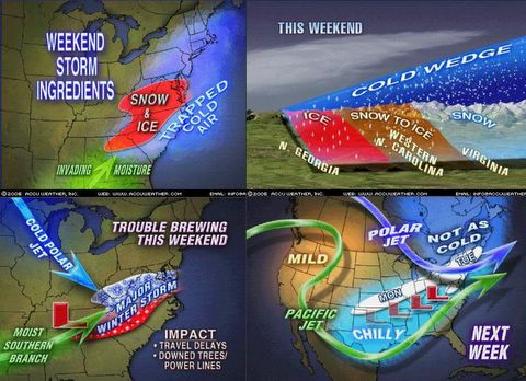
1-28 Update: The next 2 days will feature a highly complex storm moving out of the Southeast and into the Mid-Atlantic States. The areas affected with winter precipitation by this first system include the Tennessee Valley, Carolinas, Virginia, West Virginia, Maryland and Delaware from Saturday into Monday morning.
STORM 1A is now a series of Low pressure systems spread between New Mexico-Louisiana and Florida. A primary Low will emerge out of this, and will move to a position near Chattanooga, Tennessee by Saturday afternoon. Meanwhile, a large, very cold high pressure system has been dominating the East Coast from New England to Georgia. Cold air has filtered much farther south than originally anticipated, prompting winter advisories, watches and warnings into central Georgia and west central Alabama. Significant icing of up to 1/2 inch as well as wet snow is possible throughout the Southeast from central Alabama northward to Tennessee, northeast along the Blue Ridge Mountains to the Shenandoah Valley, including western and interior areas of North and South Carolina. On Saturday and Saturday night, rain is expected along the coast in areas from Richmond south to Raleigh-Durham.
STORM 1B is a secondary Low pressure that may develop along the North Carolina coast on Sunday, move northeast and draw in moisture from the Atlantic. This storm has the potential to change rain along the Virginia coast over to snow as it departs on Sunday night. At issue is the arrival of a fresh high pressure system to the north, which would recharge the area with cold air, enabling storm development.
STORM 2 is presenting an interesting situation, as several computer models have begun to show Storm 1 moving out to sea, then BACKING NORTHWEST toward New England. I am not making this up. As indicated before, this is a highly complex system which must be watched closely for unexpected changes in the outcome. It is also possible this is a "feedback error" in the modeling which tends to rectify itself within a few days, leading to the possibility that Storm 1 has the potential to stay closer to the coast. More information will be known within 24 hours once we see how Storm 1 begins to pan out in North Carolina on Saturday.
2. REGIONAL FORECAST (Saturday to Monday morning)
North Georgia to Carolinas: Snow, sleet and freezing rain in mountains on Saturday late afternoon into the evening, and light rain changing to snow and sleet in northern Atlanta. Interior western SC and NC will see freezing rain and sleet, causing possible power outages depending on amount of ice. Snow amounts of 2 or more inches are likely, with ice accumulating from 1/16 to 1/8 inch. Interior and western Carolinas will see ice amounts of up to 1/4" This will become a major, near-crippling ice storm for this region.
Virginia-West Virginia: Low 1A will produce interior mountain snows accumulating 6 or more inches starting Sunday early morning. Snow also begins early Sunday morning in the piedmont and coastal plain, changing to sleet, freezing rain, and rain along the immediate coast as the daytime warming occurs. Areas impacted include Charlottesville northwest to Harrisonburg, and then southwest beyond Lynchburg and Roanoke. Richmond will see snow change to sleet and then rain.
Maryland and Del-Mar-Val: Metropolitan DC and Baltimore northeastward to the PA line will see snow begin around midnight Saturday, moving from south to north, and accumulate 2-4 inches by evening Sunday. A mix with and changeover to sleet and freezing rain overnight Sunday is possible. A changeover to all rain along Del-Mar-Va coastline is likely until Low 1B begins to pull down colder air from Canada.
Pennsylvania: Previous storms which were expected to stay south of the PA-MD line have moved farther north than expected. If Storm 1A stays south, and Storm 1B forms and moves away as predicted, then snow amounts north of the PA border will be 1-3 inches.
Metro Philadelphia will be impacted by the leftovers of Low 1B of Sunday night-Monday, where a brief period of wet snow may develop in southeast NJ and along the Delaware coast as the storm pulls away.
New York City-Long Island-New England: Little or no impact to areas farther north of Philadelphia from Storm 1A or 1B.
STORM 1 : SNOWFALL and ICE PROJECTIONS
The overall trend is 2-4 inches from Baltimore City north to the PA/MD state line. 3-6 inches from Baltimore City south and west toward DC and northern Virginia. 5-10 inches in central and southwestern Virginia/western North Carolina/western South Carolina.
The numbers on which the storm will be graded. This assumes there is a 2” variance on either side of the grade number is you do not live at the exact location mentioned.
Overall is 2-4 inches from Baltimore City north to the PA/MD line. 3-6 inches from Baltimore City south and west toward DC and northern Virginia. 5-10 inches in central and southwestern Virginia/western North Carolina/western South Carolina.
Central PA (south of I-80, north of I-76): Less than 1 inch. Grade location: State College, PA.
Southern PA (south of I-76): 2" Grade location: York, PA
Metro Philadelphia: 2" Grade location: Phila Int’l Airport
North Central Maryland (North Balto County above Beltway, Harford, Cecil): 3" Grade: Towson, MD
Central-Southern Maryland (S Balto County/City to DC Beltway): 3.5"
Grade location: Laurel, MD
DC Metro: 4" Grade Location: Dulles Airport
In Virginia: Richmond, VA: 2" Lynchburg, VA: 7" Roanoke, VA: 9"
3. SCIENTIFIC ANALYSIS
WHAT AWAITS US AS WE HEAD INTO FEBRUARY?
This is a late-breaking development just in the last few hours, but it merits discussion. Something weird is starting to develop around Day 3 with with Storm 1 in the Atlantic. Go take a look at the UKMET and ECMWF if you want a glimpse. Do you notice how these models take Storm 1 off the NC coast, then they don't know what to do with it. The northern high appears to be blocking it from making northward movement. Could it be that the models are misreading upper level patterns and the real outcome is a more northeasterly track for Storm 1 along the coast TOWARD New England. The Boston NWS picked up on this new wrinkel early in the evening on Friday. Here are their comments.
There is still quite a bit of uncertainty beyond Monday in this forecast. Strongly negative North Atlantic Oscillation not expected to break down during this portion of the forecast. Thus expecting the various shortwaves during the middle of next week to only deepen the mid level trough across the northeast.
Though for the most part, high pressure over the midwest is expected to keep the track of any low pressures well to our south or east. however, there are a few gfs ensemble members, as well as the 12z run of the ukmet, which actually retrograde a storm over the North Atlantic toward Southern New England. Given the uncertainty, this should be considered a long shot at this time, but still something to keep an eye on.
I reason I believe this type of random changes is an example of pattern we are in that favors rapid development of large, widespread snowstorms we have come to associate with February. Here is my case for continued storminess, based on a detailed analysis of current data.
- The NAO remains negative, and while it has retreated towards neutral somewhat, is forecasted to go mild to strongly negative once again by February 1, and then trend further down from there. This would indicate more storminess and cold weather on the East Coast, due to the westward movement of the Icelandic Low, and the Greenland High backing toward Eastern Canada. This tends to block storms from heading out into the Atlantic, and allows them to impact the coastline. Also, heavy snowpack from PA northward is going to hold down temperatures next week to normal, which will allow some melting, but not a total loss of snowpack as the GFS usually advertises. I saw a forecasted high of 47 F for next Friday in Baltimore. Okay, sure. What was the forecast for this Friday on Monday? Wasn't it in the 50's almost? Today's high in Baltimore...27 F.
- A persistent “cross equatorial trough” exists in the upper levels of the atmosphere from off the Mexican Pacific Coast extending down into the western Pacific off tropical South America. This argues for tremendous moisture potential to be tapped at any time by the subtropical jet currently streaming into the Gulf of Mexico.
- Above normal temperatures in most of central and southern Canada force the northern (polar jet stream) to take a more southerly track, around the southern fringe of the warm air mass. This meshes well with a Polar Pacific High parked over the Rockies. So the northern jet can swing over the top of the high, travel southeast under the Canadian provinces and toward the Mid-Atlantic. This is called "split flow" and it results in the two streams eventually coming closer together down east.
- Much above normal water temperatures off the East Coast. This argues for enhanced moisture feed into developing coastal storms. This water may play a big role in the outcome of Storm 1 on Sunday for the Mid-Atlantic, as well as the newly alluded to possibility of this same storm retrograding toward New England perhaps Tuesday. Were that to occur, this already deepened Low pressure would have tremendous moisture available with which to work. And by then a fresh high would have arrived in upstate New York.
- Cooler than warmer temperatures off the Georgia/Florida coast argues for the persistent High that’s been there to remain. The clockwise flow around this high creates a southwest to northeast air flow along the coast. This airflow would prevent any storms coming eastward across the Deep South from just going out to sea, but push them a little farther north.
All these issues argue for any warmup in the East to be very brief, limited to perhaps one day like this week was on Wednesday. The blocking Greenland High and Icelandic Low, along with other upper level factors in East Asia, will keep sending shortwaves (small Low pressure systems) along the northern jet stream, reaching the coast every couple days. Each of these systems has the potential to develop rapidly, just like the "Clipper Blizzard."
4. PHILOSOPY BEHIND THE FORECAST
This is the part where we get to consider what is possible, given the pattern we are in. And it follows my philosophy that computer models underestimate how far north a southern origin storm can move, as well as how I might fail in my attempt to make the big call.
HOW THIS FORECAST BUST
- The NAO, while still negative, has begun a slight trend toward positive. This would argue that the storm ends up being warmer than I think, and more in line with that the NWS has on the table.
- Placement of Arctic high in upstate NY is not stationary. Projected to move east to southeast, and this is not the best arrangement for a classic East Coast snowstorm.
- Low level cold air should decay by Sunday in Mid-Atlantic, given that the high has been in place now since Thursday morning.
HOW THIS FORECAST TURNS INTO A SURPRISE SNOWSTORM
- A change of 25-50 miles north means the zone of heaviest snow shifts from south of DC to the Baltimore metro region, turning a general 2-4” into 4-8” and a Winter Storm Warning.
- A change of 50-75 miles means the entire Mid-Atlantic I-95 corridor from DC to Philadelphia receives 4-8 inches, with higher amounts in the immediate western counties as wrap-around in the colder air will increase the snow ratios.
- or...perhaps the computer models are not correctly interpreting Storm 1's movement as it relates to the High. Instead of sending the Low out to sea, the High noses out into the Atlantic more than we think it will, and the return flow actually drives the Low more north into the cold air.
5. POST SCHEDULE
This is not self-aggrandizement, I just figured that it would help if you really wanted to know when I post and when I don't. It is a simple schedule, so
- Weekday mornings: I get up around 5:00 AM, do a roundup of all the models, forecast discussions for areas in question, radar, upper air data, and NWS forecasts. I also read your comments right away, to make sure I account for your questions in the post. I do not pay any attention to TWC or Accuweather 15-day forecasts, because they are tied to the GFS. Then by 6:00 or so I am ready to start the post, which I usually complete by 6:30. In between this I munch on my cereal or oatmeal.
- Weekday afternoons: I check model changes during the day at lunch, and see if there are any changes in NWS discussions. Again, forget AccuWx or TWC. I can't read comments at school or post to the site, as blogger.com is blocked by our school server. That's okay, probably better that I focus on my real job during the day.
- Weekday evenings: When school is over and the dust/papers/mail/meetings/email settle, I do another round of checkups, and look at NOAA data also. I do a draft of the evening post, and at home my wife and I read the comments to each other, it is fun reading what you have to say! After our daughter goes to bed, I finish the post and put it online by 9pm if I can (except in storm mode, or on nights like this when there is more time). I do one more check of my favorite data sites before bed. Then the cycle starts over. I enjoy it quite a bit, helps put some thrill into the dreariness of winter, provided that you don't get hurt in the storms I forecast.
Next update Saturday morning, along with answers to your questions.