
"AND GIVE ME SOMETHING TO BELIEVE IN..."
-Poison, from the Album 'Flesh & Blood'
FIRST, JUST THE WEATHER
TUESDAY: Continued snowy in northern New England, clearing and cool to mild for rest of Northeast and Mid-Atlantic.
WEDNESDAY: Warm to start, then colder by nightfall as a front sweeps east. Some scattered snow showers with this front producing a coating of snow.
THURSDAY: Fun begins as Gulf Coast Low moves to a position near Cape Hatteras. Much colder air in place over all of the Northeast means a chance of snow late in the day from the Carolinas on north over night.
FRIDAY: Is a surprise snowstorm in the offing? Only time will tell, but at least you know it is possible, or that you are possibly going to be disappointed yet again.
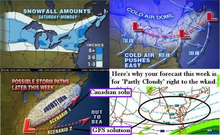
Just when you thought that winter had exhaled it's last, there might be something to believe in for later this week. A tell tale sign that something interesting will happen is when you notice all your Weather Channel and NWS forecasts are "Partly Cloudy" right through the week. I am not jumping on a Red, White or Blue Bandwagon just yet, as I want to be the proper scientist I am and see if I can make a case for either storm. Then I will sit back a day and read over that to see which one REALLY seems plausible. So no promises, just some investigation of the evidence first. I do notice as of Tuesday morning that Baltimore NWS now has chance of snow Wednesday through Friday when yesterday at this time it was Partly Cloudy.
It is odd to think that the model HPC and NWS offices leaned on a lot in the recent storm was the NAM, and now they are discounting it in favor of the GFS, which says Partly Cloudy. That was the forecast for New York City the day or two before their crippling blizzard of 1888. Oh wait, no I think it actually said, "Partly Cloudy, then rain later." 25 inches later....
EVIDENCE FOR A BIG STORM IN THE MID-ATLANTIC/ NORTHEAST
1. North Atlantic Oscillation is strongly negative (-3 deviations). It cannot stay that negative for long, much like a Category 5 hurricane cannot maintain that strength for long as the conditions creating it get broken down. What we will see as this week progresses is a retreating of the NAO from -3 to perhaps -1.5. That is going to allow computer models to begin trending north and northwest with the eventual track of the storm. The result will be that you observe your local forecasts...from the TV, TWC, NWS etc all will begin hinting more and more at a possible snowstorm late this week. Friends, this is the same setup that occured with the January 22 storm, which is why I was more confident with time of a New England blowout. This might also be why Mr. E.H. in Boston has his sixth sensors on alert, he senses the same signals we saw leading up to that storm. Remember the weather this season seems to behave opposite of the forecast.
2. Fresh cold air will be in place at the storm's arrival. This is due to a series of cold fronts which will cross the Mid-Atlantic and Northeast this week as depicted by the Accuweather graphics above. Unlike the setup this weekend, which was retreating cold air and we had more faith in that the air would stay and it just was not to be.
3. The atmosphere has a way of balancing things out over time. Like the old saying that "red Sky at morning, sailors' warning, red sky at night, sailors' delight." Only in a STRONG El Nino winter when water temps off Peruvian/Central American Pacific coast are 3 and 4 degrees above normal do you get a much-less-snowy winter in the Mid-Atlantic, as was the case in 1997-98 and 98-99. Everybody knows in their gut the I-95 corridor is due, and though time is quickly running out, "it has happened before, and will happen again, just a question of
when." Thank you Charleton for bringing that up again.
when." Thank you Charleton for bringing that up again.
EVIDENCE AGAINST A BIG STORM IN THE MID ATLANTIC/NORTHEAST
1. Trends this winter do not favor big storms. Each storm this season has either gone way north and snowed only on New England, or it was briefly cold enough to deliver snow for everyone, but only a little bit. The pattern seems to continue producing under-performing snowstorms because the Mid-Latitude blocking signal is haphazard at best as evidenced by the NAO being mostly positive for the average period of the winter.
2. Sun angle is creeping higher these days. This induces more natural ground level warming, making it harder for snow to stick or requiring colder and colder air masses to keep the atmosphere cooler longer. Hard to do when you are in the last third of winter. There would have to be a real strong shot of cold Arctic air to hang around for 2-3 days prior to the storm's arrival.
3. Limited snowcover reduces effectiveness of Canadian highs. While the recent storm did refresh the northeast snowpack somewhat, it did nothing in the Mid-Atlantic. Not a good sign for a big snowstorm right out of the blue. Snow usually falls where it has already been falling, and that is in New England. You could say that means this storm would be heading for New England again, but a positively tilted upper level trough (the bands of color showing wind movement high up in the atmosphere are angled out into the ocean) would indicate our storm is going merrily out to sea instead of up the coast. Another consequence of weak High pressure.
SO WHEN WILL WE KNOW IF THIS STORM HAS ANY LEGS OR NOT ?
I foresee more model madness and forecasting fumbles this week. Everyone is going to play the waffle game as some models will trend north, others will not, and still others will show a giant storm. Looks like another Marty Bass Alert has to go out. The tell tale sign of what's going to begin playing out is the NAO. If it starts creeping toward neutral, that is a giveaway for a northern trend and then New England, look out. If it stays strongly negative, as is the Arctic Oscillation also, then I'd say it will stay south and leave us from Washington on north high and dry. Check back later tonight for an update on what awaits us late this week.