
"SO YOU'RE SAYING THERE'S A CHANCE?"
-Jim Carrey from 'Dumb and Dumber'
or:
"I SAY IT HERE, IT COMES OUT THERE"
Albert Brooks, in the 1987 Movie Broadcast News

WEDNESDAY EVENING UPDATE: Taking care of some important family items, like fixing the car seat which is one of a few things that takes priority over the weather. It is taking longer than I anticipated, so will get back to you with updated snowfall amounts by 10PM. Keep an eye on radar, as that and not models, will reveal true colors of storm.
SCHOOL: No School Thursday or Friday for most of central Maryland, northern Virginia, and south central PA. Many other school will not take the storm seriously, and be caught with an early dismissal that will make life very hectic for a few hours Thursday afternoon/evening. No School Friday for many PA, NJ, NY, New England Schools. NWS forecasting onset of snow now sometime after 4AM in Dundalk, MD, up from a 10AM-12 Noon. I think many Baltimore Metro districts will see the handwriting on the wall and close instead of risking a messy delay-early dismissal situation. Or perhaps they will start with a two-hour delay and then give it up once the radar becomes more ominous with time. Districts farther north and east will see the situation developing on Thursday and realize Friday is a wash.
TRAVEL: BIG MESS COMING ALL DAY THURSDAY. NWS HAS MOVED UP START TIME OF SNOW TO EARLY THURSDAY MORNING. That means a tough travel day, with problems increasing throughout the day. Hence the reason why I think many schools will close outright Thursday morning. Many airport delays from DC north to Boston.
ACCUMULATIONS: Large complex storm with many precip factors, but here is the skinny for now.
Maryland... my earlier 6-12" guesstimate was not too far off as NOAA/HPC Heavy Snow Discussions call for at least 6-8" in DC/Baltimore Metro with local amounts even higher. Will do a statewide overview of amounts for specific locations. Leaning on 7" for Dundalk, 8" for DC, 10" for Hereford Area. Less on Eastern Shore and in western mountains.
Virginia/West Virginia...Tough call as many factors influencing precip type, timing, temps, etc. Complicated arrangement with downsloping, cold air damming, warm air advection from SE and overrunning upper level precip over cold dome. Basically a mixed bag with snow and sleet holding down accumulations to less than 6" overall.
Pennsylvania...Bullseye might be central and southern PA, and SE PA, where 534 dm thickness line is over area of upward motion due to mountains, which wrings out lots of snow and raises ratios to perhaps 25:1. 12 inches not out of the question, but in the 8-12" range overall.
New Jersey/New York/New England: You wanna come and play too? I think throwback and NAO perhaps trending back a touch may allow for more snow in all areas than originally forecasted. 8-12" for SE Coastal New England not unreasonable. I-95 NY to Boston I am leaning closer to a 4-8" but seems low given northern trend, and it that keeps going, could be an overall DC-Boston I-95 special. Right now 6-12" from Mass Pike south and southwest seems acceptable given QPF trends and higher ratios given colder air. Also don't overall ocean effect throwback which always seems to add another 1-3" on top of storm totals.
It appears the northwest drift has begun and our storm is getting more and more likely with each passing hour. So for fun, just sing to the tune of that song: "Do you see what I see? A coastal storm trending north with time." Do I see Winter Storm Watches ? Hmmm, where did they come from for a storm that was supposed to stay south of DC? I say it here and it comes out there... you watch and see what happens. By 9PM Thursday, Winter Storm Warnings will be posted for much of central Maryland, Virginia, south central PA, and Watches will go up for Southeastern PA. Watches will extend north above I-90 as well as encompass NYC by daybreak. Even Andy in York County will dust off his storm flag and check the gas in snowblower. You watch and see. Make sure you have 32:1 mix in that thing. Mine is ready to haul.
INFORMATION BELOW IS FROM 6:40 am POST. READ FOR COMPARISON TO WHAT IS NOW FORECASTED.
Lots of model madness and forecaster frustration with the upcoming mini Kahuna. I ask you this... if all our previous storms this winter (except for the SE Virginia surprise on Dec 26) went much farther north than originally forecasted, why should this one be any different? Why would the NWS put out all these Special Weather Statements if this storm is supposed to stay south of DC? And WHY oh why would every other model show a considerable snowstorm in the DC corridor, with some making it to Baltimore, while the GFS is heading OTL (out to lunch?). Yes there are still reasons to be skeptical, but I think this storm will show it's true colors very soon, and those colors are those of the Ravens and Redskins, perhaps even the Eagles. Let me go out on a limb and say that the heavy snow band is going to eventually fall about 75-100 miles farther north than where it is forecasted... so that means Richmond to Washington and not lower central Virginia.
"DO YOU SEE WHAT I SEE...?"
SAID THE SHEPHERD BOY TO THE MIGHTY KING
SAID THE SHEPHERD BOY TO THE MIGHTY KING
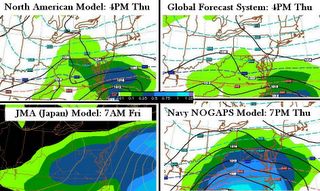
(Wednesday evening model maps, for comparison)
WHAT'S THE BOTTOM LINE WITH THIS STORM ?
SCHOOL: VERY STRONG POSSIBILITY OF NO SCHOOL BOTH THURSDAY AND/OR FRIDAY FOR MOST OF VIRGINIA and DC METRO AREAS. Baltimore Metro to see early dismissal Thu and possible no school Friday. I may take the unusual stance today of issuing a "Happy Friday" alert to my students depending on what I see the liquid equivalents doing by mid day. At the bare minimum these areas will get an early dismissal Thursday and 2 hour delay Friday for those districts that really want to squeeze the calendar. The next likely situation I see is an early dismissal Thursday, and no school Friday. Teachers: turn in your interim reports ON TIME and take extra work home, or get it done now so you don't have to. Students: Take home your A and B day binders to be prepared.
TRAVEL: WITH TEMPERATURES TRENDING DOWN QUICKLY, TRAVEL WILL BE POOR SOON AFTER SNOW BEGINS BECAUSE IT WILL STICK TO ROADS AND CREATE SLIPPERY CONDITIONS.
SNOWFALL: PRELIMINARY CALL BELOW WILL BE REVISED TONIGHT WITH STORM GRADE AMOUNTS, AND OVERALL RANGES.
MARYLAND: Overall preliminary is 4 to 8 inches. For example, in the Dundalk area, I am leaning on 5" but may have to raise that. The trend will be more snow the farther south you live, so 6-8 inches across southern and central Maryland, 4-6 inches in Baltimore Metro, 2-4 near PA border. I have a feeling these numbers will have to be revised upward, as our storm is taking a similar track to the Feb 2003 Blizzard. I will revise these numbers tonight
PENNSYLVANIA: Any accumulating snowfall will be south of I-80. Southeast and southcentral PA I expect to see no more than 3 inches.
VIRGINIA: Heaviest snow to setup in a band from Richmond to Washington, where amounts will range 6-10 inches.
WEST VIRGINIA: Panhandle area 3-6 inches, western mountains 1-3 inches as you are on western fringe, just like you were in the 2003 storm and it's a darn good thing you didn't get that 30-40 inches of snow, huh?
NORTH CAROLINA: A maximum of 6 inches in interior mountain areas, with 2-4" in the Research triangle area. Again these are preliminary numbers which will be revised tonight
ANALYSIS...Please check back around 5:00 PM for late afternoon update, followed by storm grade amounts at 8:00 PM.