Post time is 8:30 AM because our hard work has been rewarded here in Baltimore with a 2 hour delay throughout the area. How about a quick roundup to see where the chips did indeed fall with this forecast?
Baltimore: Snow was predicted for Thursday night on Tuesday, accumulations in Southern Balto County... less than 1" and a 2-hour delay. 2-3" predicted for the Maryland Mountains. Result: <1">. Forecast verified? Yes. Areas exceeding predictions: Northern Baltimore County, South Central PA... 3-4"
Eastern Massachusetts: 2-4" of snow predicted on Tuesday for Thursday night. 9:30 PM Thursday revision to 4-5" for areas west of Boston, before NWS or TV forecasters caught on to the situation. Result: A widespread surprise snowstorm with amounts ranging from 3-6". Storm Grade: A. Forecast verified? Absolutely. Weaknesses: Storm grade of 2" for Logan Airport probably did not materialize, so grade there was probably a D or an E.
Philadelphia-New York: Little or no accumulation predicted, though alluded to in earlier forecasts but that does not count as a verifiable prediction. Result: 1-2" of wet slushy snow scattered throughout the region.
Other regions... Virginia, West Virginia, North Carolina? I will do a roundup of those forecasts and verifications tonight.
BASIC EAST COAST FORECAST FOR THE NEXT 5 DAYS: Wonderful sunshine, tranquil weather, crocus-watching, park strolling, gardening, widespread calls for an early spring. Temperatures in the 50's south of Boston, upper 40's to 50 from Boston on north. A good opportunity to check the snowblower, get the oil changed, get your hair done, and get ready for the Big Kahunas.
Our precious NAO has done a role reversal, shooting up sharply positive in the past 2 days. This is going to lessen the blocking in the North Atlantic for a short period. But relax! We need this to happen so the Ocean storm will lift out of the picture, so it will stop tapping the southern stream and drawing it off the East Coast. With that Ocean storm in place, we cannot get big nor’easters on the East Coast as it ends up pulling most of the energy south.
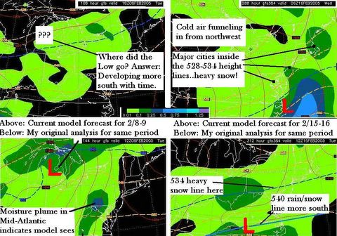
I have been watching the GFS closely, and notice slight trends with each run that bring the Great Lakes system next Monday-Tuesday a little farther south and east. What I have posted above is the comparison over 2 days of the GFS runs for Tue Feb 8 and the Wed Feb 16. While the computer will obviously continue to change with each run, the TREND is beginning to show clear signs of Kahuna #2 for the Feb 15-17 time frame. You will notice that the BLUE line has moved much farther south, and the 534-528 thickness lines are usually where the heavy snow bands setup in the southwest and northeast zone of the tightening jet stream vorticity maximums. Much can change with a system 2 weeks away, but the point I want to make is that the GFS has this uncanny ability to predict a big storm ALMOST to a T way out in the future, then spend the next 10 days backing away from that idea, only to have what it called for come true after all. Look way back at my posts for the JANUARY 14 early call on the Jan 22-23 storm to see what I mean.
Kahuna #1 is going to be harder for the computer to identify at first, because whenever the GFS shows a system cutting up through the lakes, it fails to recognize the development of a secondary Low. However if it trends the primary Low more and more southeast with time, at some point the reality of physics will allow for a secondary to develop around the Carolinas. BK #1 is going to be more of a northeast event than a Mid-Atlantic event, but then again, you heard that before, and the opposite came true.
Kahuna # 2 looks to be quite impressive. Though you would look at the model printout and say, “It’s going out to sea and will miss us!” that is a premature assessment because it is a widely known fact throughout the forecasting industry that models always project large systems like this to be farther EAST or SOUTH than what ends up really happening. A number of NWS offices have commented on that very situation this winter, especially with the GFS and NAM (North American Mesoscale). Were that not true, why did it snow like MAD from North Central Maryland all the way to Eastern Massachusetts?
Happy Friday! Next post later tonight.

