
Saturday evening tech problem: Comments appear to be temporarily disabled due to a problem with the Haloscan.com server. Ignore the message about "moderated posting" as that is not true and continue to post your comments, the server will catch up with itself soon enough.
SITE UPDATES: A few revisions made to the links column to better help you find information. Forecast nuts like me will drool over the new 4-panel model animation site I found today. Check under forecast models for a link. It is a wild ride. For normal people, ignore this.
BEFORE THE FORECAST, SOME WEATHER HUMOR:
If you want to see the two most hilarious TV weathercasters in the history of broadcast meteorology, click on these two sites courtesy of DC Capital Weather.com. Get some anbesol first for your jawbones, and don't drink any fluids before watching, because you may split your sides laughing, and strain your jawbones. The TV stations featured are Athens, Ohio and Charlotte, South Carolina.
FIRST, JUST THE WEATHER
WEEKEND: Tranquil and delightful conditions throughout the eastern 1/3 of the country as high pressure dominates. Temps will not warm as much in New England due to a refreshed snowpack, holding in the mid 40's. Further south and west from New York State, through Eastern Pennsylvania, Maryland and Virginia...50's will be common. Western PA and MD will stay in the upper 40's.
EARLY NEXT WEEK: As the unseasonably mild and pleasant weather continues into Tuesday, many will begin to post on this site that winter has ended. Sunshine and temperatures well into the 50's throughout the Northeast, perhaps even 60 by Wednesday south of the PA/MD line. The except is northern New England, which will hold in the mid 40's.
WEDNESDAY: This is the day everything begins a rapid shift back to winter as we know it. A "frontrunner" low will head through the St. Lawrence River Valley with a trailing cold front to cross New York and then Pennsylvania on Wednesday. For many locations throughout the northeast, the highest temperatures of the week will be observed Wednesday night or Thursday morning. A sharp drop in temperature accompanied by rapid changeover of rain to snow will occur from east to west. However, the development of a secondary Low along the VA/NC border would allow upper level energy to begin a transfer to this secondary.
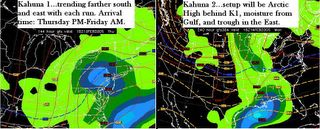
THURSDAY: The weather on this day will reflect the major pattern change, with temperatures 15-25 degrees colder than what you currently see in your local forecasts. What first appeared to be only a northeast front-runner "clipper" with just rain along the coast may rapidly become a surprise Nor'easter by Thursday afternoon. This is due to a second piece of energy developing on the heels of the cold front in the southern Tennessee Valley, as indicated on recent precipitation forecasts. All major computer models have continued to trend this second system further south and east with time, as well as coastal redevelopment near the Mid-Atlantic on Thursday.
Let me be the first to say I firmly believe, as I did with the Jan 22-23 storm 7 days prior to it's arrival, that the Feb 10 storm (Kahuna 1) will end up being stronger, colder and snowier than forecasted by the NWS.
FRIDAY: A harsh return to winter awaits on the heels of this storm, as all the cold air building up in Canada will come surging southeast in the form of an Arctic High behind Kahuna 1. Temperatures will be back to or below normal levels.. highs in the 20s for Boston and NYC, low 30's for Philly-Baltimore-DC. Overnight lows dipping back into the teens. This in turn sets the stage for Kahuna 2.
NEXT, THE ANALYSIS
IF YOU DON'T WANT MIND-NUMBING SCIENTIFIC GOBBLY-GOOK, STOP HERE. Just continue to check the first section for updates on Kahuna 1's development over the next few days.
A variety of computer solutions are being presented for the Tuesday-Friday time period, as you would expect. The variance is due in large part to computer confusion over the persistent Atlantic storm, and the recent but temporary reversal of the North Atlantic Oscillation toward positive. As of this morning, it has begun a very slight trend toward netrual. Remember that index is a signal of what is about to happen in the next 2-3 days. So we should expect a temporary warmup in the Northeast. If that bar dips below the baseline, by say Tuesday, then it is an indication the atmopshere is about to give you major whiplash, in the form of rapidly falling temperatures and a big storm to boot.
KAHUNA 1 will resemble the Jan 22-23 storm in that it starts as a system that first appears to be cutting to the Lakes, but then shifts a little farther south and east, transfers energy to the Del-Mar-Va, and sends a bigger storm up to New England. Why do I say this? Since my days of public forecasting for central and western Pennsylvania in the early 1990's at the Penn State Weather Center, I along with many of my colleagues, have observed a consistent error in the Global Forecast System (then called the AVN). This computer program has demonstrated a northward bias of 200-300 miles with it's early projections for northeast storms in the face of a negative NAO, and a southward bias of 200-300 miles for storms in the face of a positive NAO.
The most recent and worst example IS the Jan 22-23 storm, which during a strongly negative NAO was sending our New England Blizzard SOUTH of Virginia and off the coast, not even to TOUCH Massachusetts at all? Believe me, I was reading NWS discussions for days before and even right up to the storm. NWS offices from Richmond to Baltimore to New York were following the GFS lock-step and thus their forecasts reflected this. Meanwhile the European (ECMWF) and UKMET had nailed that storm for days as being a major snow event for the Northeast. Do you remember how your local forecasts suddenly changed overnight when the GFS did a 180 and finally picked up on how the other models had identifed the pattern change? The GFS had initialized in it's data stream the forecast for a positive NAO at the time, even though the actual index value was already strongly negative. This is why I held to my contention that the Jan 22 storm would end up going farther north, be stronger and colder than forecasted. Now that we are halfway through winter, NWS meteorologists are finally noticing this bias and trying to correct it in their regional forecasts.
Snowfall amounts? It would appear to me that unless we see evidence of a solid coastal secondary forming around North Carolina by Thursday, then the heavier snow will be the farther north you go. I will use Baltimore as the dividing line. In the first phase of the storm, I would expect there to be LESS THAN 6 inches in this storm south of a line from DC-Baltimore-Philly line, and 6 inches or more north of that line.
The problem with southern Mid-Atlantic cities will be that snowcover is gone, and roads will be warm at the arrival time of K1. So what we need is an evening arrival of the storm to take most advantage of overnight cooling. Moisture will be aplently, so the "column" will already be saturated. Once rain changes to snow, evaporative cooling can take care of the rest to chill the atmosphere down to where the snow can overpower the warm surface.
Any discerning reader who knows their synoptic weather patterns might notice that the potential exists for the first cold front arriving Wednesday would push Kahuna 1 out to sea due to the front's northeast to southwest orientation. Initially that seems to make sense, but with the second system projected to develop in the Tennessee Valley, it is going to tap Gulf moisture, surge warm air out ahead of it due to counter-clockwise rotiation. This warm air will clash with the cold front in the mountains, producing those snaking stationary fronts you see with northeast moving systems. It is along this stationary front that Kahuna 1 will traverse, and once the Low deepens near the coast, it will take the warm air with it, and allow the cold air to sweep behind. Thus you get a coastal storm tapping a refreshed supply of cold air as it moves northeast.
KAHUNA 2 will be the classic setup for a Nor'easter to affect the entire East Coast, as a big High builds in behind Kahuna 1, the cold air gets entrenched, the southern stream buckles north, and the upper level trough in the east forces the northern stream underneath it. Presto! Insta-Noreaster. The rain snow line will be in southern Virginia, so areas on south of that will be just rain, but north of this line, heavy, powdery snow is becoming more and more likely.
I will elaborate more on this storm later, as the GFS is showing a very interesting event setting up for my February 15-17 time frame, and showing it's usual southward bias when the NAO should be negative for that period. The new model runs should delight powderhounds near and far as it has liquid equivalents of 1.00 plus all up and down the coast from DC to Boston, and upper level height thicknesses of 528 and below. That only means ONE THING gang.... heavy, heavy snow with fairly high ratios. I'm sure my friends in the Boston area will start doing their QPF analyses now. Run the math guys and see what you come up with. Remember, those models have a 200-300 mile error this far in advance, which is why I am confident this storm is going to be a winner. Click on that link for a scientific basis of what I am talking about with model error.
I will post an overview of what the major models are showing.
If anyone can help me ENLARGE the graphics I post with each column, that would be great. They are too small to be any good, and it helps if you can see exactly what the computer model is predicting.
FINALLY, THE PHILOSOPHY
I read an interesting discussion just the other day which said that several offices were advised to follow the European model in their forecasting for this upcoming event. The office terminology is "per HPC guidance." To understand this, a small history lesson first:
HPC is the Hydrometeorological Prediction Center, which is the current day version of the original National Meteorological Center, established in 1958 and then reorganized in the 1960's as a part of NCEP (the National Centers for Environmental Prediction). This center has provided forecast guidance and analysis for NWS Forecast Offices for a long, long time. They produce the QPF reports you see on this site, among many other things. Kind of like the NFL Commissioners, who decide on the location of the SuperBowl, right? Not the two winning teams who will be playing it. (Someone correct me on this if I am wrong).
The National Weather Service, as old timers will remember, was originally called "U.S. Weather Bureau" for many years until it was reorganized under NOAA (the National Oceanic and Atmospheric Administration) within the Department of Commerce in 1970. How's that for a quick history lesson on U.S. Government Weather Services? NOAA... is the umbrella organization that oversees all these agencies, including the NWS, the 9 centers of NCEP and many, many more. But the forecasting guidance, aka the "office memo" on what to do about this storm or that one... comes down to your local NWS office from the HPC, the research branch of the NWS. So when HPC recommends something, your local office usually does what it is told.
NWS offices have been told to follow the ECMWF guidance for this event, at least temporarily. Well, the European has totally backed away from the original idea of a monster cutoff upper level low trouncing Chicago with a major snowstorm mid-week. The only other logical direction for this storm to develop is further south and east, in the face of a NAO that will begin trending neutral and then negative, while the PNA (Pacific North American Teleconnection.. a signal of high pressure blocking in the west) will begin to trend back toward neutral. When you have a positive PNA and a negative NAO, it means the southern and northern jet streams are close to or about to PHASE, baby!
And those of you who frequent this site and understand the terminology know that phasing streams only means a big storm, with a cherry on the snow-whipped cream.