
"DON'T STOP THINKING ABOUT TOMORROW..."

This picture was taken at 8:30 PM Monday February 28. This is the Dundalk High School Faculty parking lot. Now compare that with the same picture I took and posted last Thursday night. Go to to the archives and find the post for Friday February 25 with the attached headline: " A 4 day weekend for some, a 6 day weekend for others." Look at these two pictures and tell me if you think there will be school tomorrow in the Baltimore Metro Region.
DISCLAIMER: This in no way is a criticism against the hard working snow removal crews and custodial staff which have had to deal with this situation 3 times in 5 days. They work around the clock sometimes but are never fully appreciated because the public does not seem them up at 3 AM working feverishly to get schools ready. This picture is posted to demonstrate that weather and road conditions tonight are WORSE than they were Thursday night. Not to mention that my hand was colder and thus the pic more blurry.
SO DON'T STOP THINKING ABOUT TOMORROW, CAUSE FOR ALL YOU OUT IN SCHOOLHOUSE LAND, IT'LL BE ONE MORE DAY FOR YOU TO ACCOMPLISH WHAT YOU DIDN'T DO YESTERDAY.
I am going out to shovel now before it all freezes solid. It sure it pretty out there.
IT'S BEAUTIFUL....FOR NOW.

As of 5:00 PM, it is still snowing quite nicely in Southern Baltimore County, MD. Any talk of the rain/snow line coming this way is now going out with the storm as it begins the long awaited drift to the northeast. Check out the latest satellite loop as our Big Kahuna 1.75 is bombing out as it heads towards New England. Light to moderate snow with occasional heavy bursts will continue throughout the Baltimore-Philadelphia corridor and into New York City for the next 3-6 hours. Central and eastern PA will also continue to see moderate snow throughout the evening. Stormin' Norman on ABC 2 in Baltimore is in another universe as he says the storm has shifted to the west a little. You decide for yourself based on the radar and current observations if you can identify a shift to the west. I guess a center of Low pressure 100 miles off the Virginia capes classifies as "shifting to the west."
Please pardon the sarcasm, it is meant only in scientific accountability that if you are going to tell the public something, you have to tell them the truth and not bend the data so it fits what you forecasted.
It is a different ball game in western PA due to interaction with the Ohio Valley system. We are also watching a large batch of precip pivoting east under the Blue Ridge mountains. That might make it to the Bay and change to snow in the cold backlash, bringing another inch or two to southern I-95 later this evening and overnight. Some TV graphics show this Low swinging over PA and bringing rain with it... that is simply not going to happen due to the entrenched cold air firmly in place. This is demonstrated on the radar as you can clearly see the rain over southern WV swings east, runs into the mountains and emerges on the other side as snow.
The amounts I forecasted in the earlier post stand because I refuse to change my tune with every run of a computer model. If the amounts fall short, I will grade them and explain why. If they go over, same deal. If YOU think I am bending ANY data to fit my forecast, then be sure to let me know in the comments. We want to have a level playing field here and the best way to do that is to leave the data as is, and grade ourselves against it, NOT "curve" the data so the forecast performance looks better in eyes of the public.
WHAT ABOUT SCHOOL? My gut call is no school tomorrow from Baltimore County north, but we could see a 2-hour delay in the city. Howard is under pressure because they are out of days. Tonight the game changes a lot though now that darkness has arrived, temps are dropping and crew have 12 hours to do whatever they can to make schools ready. A lot of refreezing will occur in many side streets, secondary roads. I think the heavier amounts in northern parts of counties like Baltimore, Carroll, Frederick, Harford, Cecil will save the day for their southern counterparts, but be prepared to be in on Wednesday, even in PA schools. NJ schools probably out Tuesday if not a delay. NYC schools usually don't cancel unless there is well over 6". Boston schools...done deal for you. 8-12" is enough to knock at least one day out of this week. I will monitor this closely in the evening, but I am going to bed on time tonight just to be safe.
ANY MORE SURPRISES WITH THIS STORM? Plenty of uncertainty in how much snow for Boston, NYC... concern over movement of Ohio Valley system...surprise snow enhancement in Central PA might bump up totals 3-4", extensive backlash might dump 2-3" more than expected on coastal NJ, Long Island...western Philly suburbs could reach 12" are you kidding? There is lots more surprises yet to go. Temperatures plummet after the storm, it will feel like early January instead of early March...as she roars in like the Mother of all Lions.< /div>
That headline means that now snow has begun, you can breathe your sigh of relief (or horror) and get back to the regularly scheduled program... your life. We all know the anticipation of a storm is sometimes as fun as the actual storm, but this one has been playing hard to get for a few hours.
First, thanks to Julee in Hereford, Baltimore County... the official Foot's Forecast librarian, for searching the entire internet at 1:00 AM this morning to find the New York Times article about the errors in the North American Mesoscale. We will find it eventually. I'll ask Mr. Abrams at Accuweather if he can specify where in the paper he read this.
NEW YORK: Binghampton...6. Central Park...7.
NEW ENGLAND: Hartford...8. Providence...12. Boston...9. Worcester...10. Woburn...8
(please note that these amounts will be adjusted slightly as New England is in the second period of this storm, tonight to tomorrow afternoon. The interaction of the two lows may re-energize the snow and increase amounts in a second phase)
Thanks to all who posted observations, please continue doing so throughout the evening. Here is a good indicator for nervous teens about school...if your local "Snow Emergency Plan" is in effect, you have no school. That means places like Baltimore County/City have 12 hours to get the job done.
If there are any other burning questions I have not answered, feel free to post in comments and I will do my best to answer.
TODAY IS THE FIRST DAY
OF THE REST OF YOUR LIFE

That headline means that now snow has begun, you can breathe your sigh of relief (or horror) and get back to the regularly scheduled program... your life. We all know the anticipation of a storm is sometimes as fun as the actual storm, but this one has been playing hard to get for a few hours.
First, thanks to Julee in Hereford, Baltimore County... the official Foot's Forecast librarian, for searching the entire internet at 1:00 AM this morning to find the New York Times article about the errors in the North American Mesoscale. We will find it eventually. I'll ask Mr. Abrams at Accuweather if he can specify where in the paper he read this.
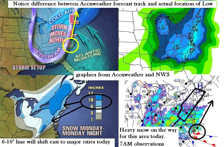
Look who's joining the party.. (sort of). The NAM (North American Mesoscale) run as of 12Z (noted by Steve) now as placed the Low just off Nags Head, NC with a NNW movement over the next 6 hours, then a job back east after 12 hours. Awfully far east for a storm that was being written in stone as heading up through the Appalachians, but welcome aboard either way. Baltimore NWS notes that Gulf Stream bouys report pressure falls along the stream in an ENE fashion, indicating the path of our storm will follow a route that returns heavy wet snow throughout the day back over the I-95 corridor and well inland to western MD, central/southeast PA, NJ, SE New York and moving up to New England tonight. I believe the increased pressure gradient moving north will tighten up the Low sooner than the model is depicting, and the elongated W to E structure it shows later tonight will close in. I believe the evidence for my take on that is the fact that the 540dm line moves west on this model until midnight, crossing I-95 from PHL south, then suddenly shifts EAST as the low passes to the north. This is why NWS has cut back on some totals, as well as the concern for the ever-hated dry slot trying to work in from the southwest.
Cheers for evaporating cooling. For powderhounds, this is a good thing because it will counteract the so-called "warm air trying to work it's way in" that the NWS claims will cut down on amounts and change things over to rain in Southern Baltimore County, New York City, Boston, etc. I understand those concerns and they are warranted. It will be a fun battle to see how the cooling can counteract the daytime warming and northwest intrusion of warm air. Hey kids and teachers, at least you're off school so enjoy that much even if you get 2" less than you anticipated. I would consider LOWERING amounts to be a wholesale change from 10 inches to 4 inches.
The other issue to deal with is Poor Pittsburgh! I see the rain there and in Ohio, but I also see the cold wedge of air on the west side of that rain. What is going on? you ask. The Great Lakes low has rematerialized, and I would have to admit that the two jet streams are probably NOT going to phase together until much later in the game. Hence a warm slot is working in from the southwest. But evidence of my theory that the storm is heading east and will drag the snowline with it is the big push of cold air driving way down east side of the Appalachians into western North Carolina. This will enhance the pressure gradient and increase the snowfall once it begins. That cold air is firmly entrenched, and while the snow will not be light and fluffy, it will compensate by being heavy, thick and hard to see while driving, especially later during evening rush. NWS has dropped the "Heavy Snow Warning" in the Baltimore-DC area, but snow totals are pretty much where they have been...overall 6-10"
There are a few surprises still waiting... such as what will the Ohio Valley/Great Lakes Low do? Will the upper level energy dive underneath and re-energize more snow on the backside as we have seen before this winter? Will the two Lows phase near New England, or stay separate? What about school Tuesday? Will there be a change to rain? I have to get some grading done so I can feel really productive and reassure myself I used this time to it's best advantage. Later this afternoon, I'll return with another roundup of observations.
HEY TEEN POWDERHOUNDS (OR ANYONE ELSE)... One of our loyal readers has created a chat room exclusively for this site. Just paste this link into your browser, click on the button once there, wait for the chat to load, and start insta-blogging away. You can report minute by minute snowfall totals if you so desire. Please ignore the "inappropriate" advertising to the right of your screen in this window, at the moment we have no control over what kind of ads are there, but are working to fix this.
FOOT'S FORECAST CHAT ROOM: http://www.geocities.com/footsforecast/ Many thanks to Brandon from Dundalk High School for putting this together.
FOOT'S FORECAST CHAT ROOM: http://www.geocities.com/footsforecast/ Many thanks to Brandon from Dundalk High School for putting this together.
SNOWFALL TOTALS
minor update as of 12 noon
This is for the period 12AM Monday to 12AM Wednesday. These amounts are "mostly final" as I may adjust slightly by an inch or two before the storm ends, but otherwise the call stands pretty much as is. . The FINAL WORD is this event is going to be MOSTLY SNOW with little or no changeover to rain due to the farther east track of the main coastal Low. The secondary Low in the Ohio Valley will play a role in the Tuesday-Wednesday period, but that will be dealt with later today. My totals stand because we've seen several instances of wraparound snow that delivers another 1-2 inches when we thought the storm was over.
VIRGINIA: Roanoke...7. Charlottesville...9. Loudon County...8. Washington...6. Richmond...3 Hayes...rain snow mixed later, up to 1"
WEST VIRGINIA: Martinsburg...10. Harper's Ferry...9. Elkins...8.
MARYLAND: Baltimore...6. Dundalk...7. Annapolis...4. Odenton...5. Ellicott City...8. Parkville...9. Frederick...12. Hagerstown...12. Myersville...12. Westminster...10. Towson...8. Aberdeen...6. Elkton...6. Salisbury...2 after rain changes back to snow. Crisfield...rain, then 1"
MARYLAND: Baltimore...6. Dundalk...7. Annapolis...4. Odenton...5. Ellicott City...8. Parkville...9. Frederick...12. Hagerstown...12. Myersville...12. Westminster...10. Towson...8. Aberdeen...6. Elkton...6. Salisbury...2 after rain changes back to snow. Crisfield...rain, then 1"
PENNSYLVANIA: Pittsburgh...rain then back to snow later...4.5 total. Altoona...5. State College...7. Harrisburg...9. Lancaster...11. Downingtown...10. Exton/Malvern/Paoli...9. Philadelphia...9. Bucks County...10.
NEW JERSEY: Rutgers..sleet/snow mixed back over to snow later...6 inches by Tuesday noon. Trenton...7. Cape May...rain/snow mixed then back over to snow later...2 inches. Sorry Frank it is not bigger than you hoped. I'll take 50% of the blame and the other half we blame on the geography of Jersey.
NEW YORK: Binghampton...6. Central Park...7.
NEW ENGLAND: Hartford...8. Providence...12. Boston...9. Worcester...10. Woburn...8
(please note that these amounts will be adjusted slightly as New England is in the second period of this storm, tonight to tomorrow afternoon. The interaction of the two lows may re-energize the snow and increase amounts in a second phase)
IF I MISSED YOUR CITY, OR YOU WOULD LIKE A PREDICTION, PLEASE POST A COMMENT AND I WILL ADD YOU TO THE ROUNDUP. If you disagree with the totals, no problem, post a comment explaining why with scientific basis. I will be at school for a short period of time and will comment again in about 2 hours. I notice as of 8:30 AM that IT HAS BEGUN here in Baltimore. Enjoy.