FIRST, JUST THE WEATHER
A quick look at the next 2 weeks indicates that we (the Northeast U.S.) are locked in an cold, windy and stormy pattern that will produce another minor to moderate snowfall on Saturday-Sunday from the Mid-Altantic into New England. This will be followed by a brief warmup on Monday-Tuesday of next week which will reload the cold in eastern Canada and allow it to explode southward right before a new storm arrives from the Southwest U.S. This storm has the potential to become Kahuna 3. (A Big Kahuna as referred to on this site would be a storm which delivers at least 12” of snow to a major east coast city.) Please note that I have not read anyone else's analysis on this, it's only me, the models and my mind.
The timeframe for this event is Wednesday-Thursday, and it will be followed by a tremendous surge of Arctic air at least 20 degrees below normal blasting southward to engulf the entire eastern third of the country right into the weekend of the 11th.
From next weekend forward into St. Patrick’s Day, the pattern is ripe to deliver a continous round of cold blasts and small clipper storms, any of which has the potential to develop snow on their way to and once they reach the coast. This summary is based on an analysis of the current GFS model output and a consideration of upper air indicators, as well as the 2-week trends of the North Atlantic Oscillation, among other things. A detailed analysis of each of the factors follows this section.
WEDNESDAY: As you have already figured out, it will be cold and windy. Not a pleasant day for the start of spring sports. The remnant low from Kahuna 1.75 is swirling in the Gulf of Maine and the entire Northeast is being raked by backlash winds and flurries, except for the Great Lakes, which have turned on the snow machine again for their cities..extending into western and central PA.
THURSDAY: As the low departs, the leftover snow will lessen and disappear. Continued cold, blustery, and well… more like January than March with a high of 38 in Baltimore when it should be 52 by now. Fields partially snow covered (in Baltimore)
FRIDAY: Slight warming ahead of the first of many clippers as it dives southeast from the Lakes. Otherwise dry and still a little windy. Fields wet with some snow still.
SATURDAY: This clipper has the potential to deliver up to 4” in western and central PA with perhaps 1-2” in southeast PA until it can reach the coast and tap Atlantic moisture. A straight east track across PA to NJ would deliver snow on the north side to New York, Long Island and possibly SE New England. A northeast track would bring more snow to New York and New England. The maximum extend of snowfall would be 4-8” but that is unlikely. A general 2-4” snow seems reasonable from Pittsburgh and the Seven Springs area streaking eastward, bisecting the PA/MD line. Some models are sending this into Virginia with a healthy little 3-6" snow there...probably too far south. More on this as it gets closer.
SUNDAY: Lingering flurries and chilly with some wind.
MONDAY-TUESDAY: A new system approaching the eastern Great Lakes will send welcome southwest winds across the Northeast, raising temperatures to about 5 degrees below normal. For example DC should be 53 by then, but will actually be 47. Baltimore 52, actually 45 and so on.
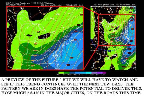
WEDNESDAY-THURSDAY: This is the current timeframe targeted for development and impact of Kahuna 3, which is expected to form on the heels of the leftover front from the front runner low going through the Lakes. Arrival time would be early to mid-morning Wednesday, lasting into Thursday morning. Cold air will quickly recharge behind the front runner low, and snow would quickly break out along the I-95 corridor given this setup. Liquid equivalents being pegged to this event at .75 – 1.25 for the major cities. With a snow ratio of 10 to perhaps 15:1…the potential exists for 12 to 18 inches to fall out of the SKY. However, as we have learned in our last storm, 2 days of warming will allow roads to be above freezing at onset of the snow. The difference is there much more cold air is expected to accompany this storm, so snowfall rates will be higher, but perhaps 3-4 inches will be lost to melting. What will appear to be a 12-18 inch storm may be cut down to an 8-12 inch storm…but temperatures on Wednesday 3/9 and Thursday 3/10 could be in the upper 20’s, so that will enable the storm to somewhat counter daytime solar heating.
Remember the March 1993 Blizzard occurred on 3/11, and despite higher sun angle and days of 50 F I advance of the stor, every major city from Atlanta, GA to Portland, ME got 12 inches or more, ON THE ROADS.
HOW CERTAIN ARE WE OF THIS SCENARIO? As the NWS would say, confidence is medium to low. If the storm develops but the upper level polar vortex sitting nearby in eastern Canada is somehow not involved, it will be a snow to rainstorm for most areas. If the vortex gets involved early in the game, it will resemble the March 93 Superstorm.
WHAT DOES MR. FOOT THINK? Well as a card-carrying Powderhound, you know I am rooting for snow, but only if the atmospheric dynamics support the idea. Our last storm was nice, but not enough cold air was available to let it crank up the way you or I wanted. This time around, the TRUE cold air is being held at bay BECAUSE of the storm which passed, and the next two coming. The front runner Low on Monday-Tuesday is the key to allow direct discharge of polar air behind it into the Northeast. The NAO continues it’s long march into another universe (-6, -8 we have no idea really) and I think that is one of the critical elements which can give rise to another significant snow event.
WHAT EFFECT WILL THIS HAVE ON THE MONTH IN GENERAL? This over-abundance of cold which should have been spent in December, January and February is now being worked out of the system. It will take a while to do this, probably 2-3 weeks. I would not expect a consistent return to normal temperatures until at least the weekend AFTER St. Patty’s Day. But I do think March will follow it’s traditional route… in like a lion, out like a lamb. It is not impossible to see much-above normal temperatures by Easter, maybe 70 F? Maybe 80 F ? It has happened before, and this March I believe will go to the extremes for both sides of the aisle.
ANALYSIS OF THIS PATTERN
Unfortunately I had network problems this morning, and was not able to complete the next section, but I will put that online later today or tonight. Here is the one paragraph summary:
Last big storm sends heat pumping into the Labrador Low and Azores High pressure ridge poking into Greenland. This warm air enhances both systems, creating a double barrel flow into far northeast Canada. The polar vortex now located in SE Canada is blocked by these two systems. Each Low that passes by uses it’s counterclockwise motion to enhance the double barrel effect which puts increasing pressure on the 500 mb Polar Vortex swirling about. Meanwhile a strong west coast ridge forces the split jet stream to ridge up over the ridge into far northwestern Canada, and the rides down east side of rockies towards northeast. The “front runner” low on Tuesday is going to be little boy who pulls his finger out of the dam, allowing the Vortex air to come charging in behind that system right into the face of the newly energized southern stream riding along the southwest winds ahead of the front runner cold front. Combine these two forces together with the possibility of phasing along the Mid-Atlantic coast and you have a major snowstorm on the docket.
Storm Grading: reports still coming in, thank you to all who posted on that. When all data is in we will do a roundup of the grades and an overall GPA for the storm forecast.
Tuesday morning 3/1 update


