
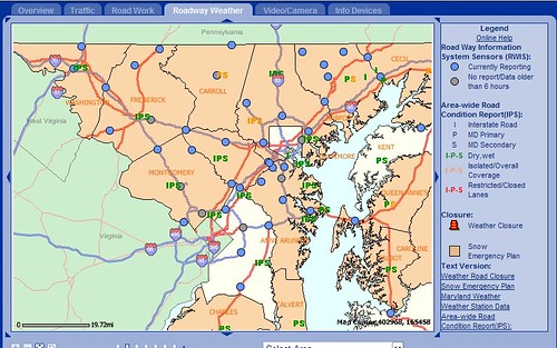
Overall this map is indicating most major roads in Maryland are at or above 32*F as of this 9:45 PM update. You can roll over the little dots and see roadway conditions. However, most counties in this image have their snow emergency plans still in place, except for Baltimore City, Prince Georges and Kent. That takes us to the next graphic, current regional surface temperatures.

While some of you are no doubt disturbed by the slot of warm air to your west, keep in mind it has been there for many hours now and has not really advanced much. Also refusing to budge is the wedge of cold air that's deep into Virginia. This is due in part to the recent snowpack that's been established over the past 12-16 hours, and the fact that a large region has essentially similar temperatures. If my facts are straight, that is called a "Baroclinic zone" in that the air mass takes on the characteristics of the area over which it occupies, thus influencing the weather underneath. If I'm off base with my concepts, I encourage the professional meteorologists who frequent this site to please help set the record straight on this. Which leads to our third map of the night: 3-hour pressure changes.
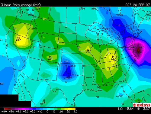
This connects the other 2 maps together. The dark purple shading off the DelMarVa coast is the developing secondary Low, as indicated by 3-hour decreases in surface millibar pressure. This low is forming, but will take a while yet, and by morning the precip should have cleared Philly and NYC with the fringes scraping Southern New England. Point of the map is if that weak Low forms in conjuction with the High to the north and a cold wedge in place, it will help to reinforce the cold over the region even with very nominal counter-clockwise air flow...because it is in tandem with air flow south out of the High. (Many thanks to Mr. TQ for providing the link for this during the afternoon on Sunday.)
WHAT ABOUT SCHOOL ON MONDAY?
Given what observations you've made about the maps I provided, here's a call that hopefully seems reasonable to you:
CLOSED: Frederick, Carroll, Montgomery
2-HR LATE: Anne Arunde, Howard, Harford, Cecil, SE York County PA
1-HR LATE: Baltimore City and County
3-HRS EARLY: Howard County. (Ha just wanted to see if you were attentive)
MY GUIDELINES FOR ACCURATE PREDICTION OF CLOSED THIS TIME: Condition of secondary roads, extent of icing overnight from dropping temps, expected daytime temps. This is assuming most schools will be able to clear their parking lots, sidewalks by 6:00 AM.
That is all for now, see you in the morning for the morning reports.