
"IT'S EITHER THIS WAY OR THAT WAY,
IT'S ONE WAY OR THE OTHER..."
-Enya in Anywhere Is, from the album Paint The Sky With Stars
3:45 PM REVISION: 2/24/07
SIGNIFICANT ICE STORM TO IMPACT THE MID-ATLANTIC REGION SUNDAY INTO MONDAY. IF YOU HAVE NOT REPLENISHED YOUR ROAD/DRIVEWAY SALT, IT MAY BE TOO LATE AS LOCAL HOME DEPOT SUPPLIES RAN OUT QUICKLY LAST TIME.
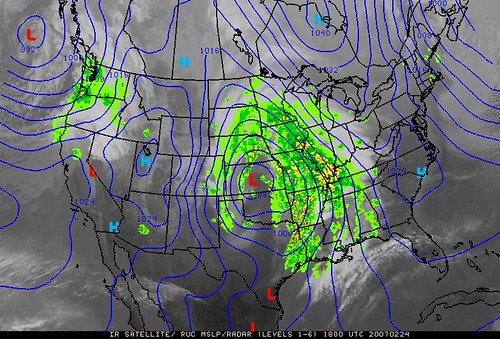
On Accuweather.com, view the Current radar loop for Midwest and Northeast, projected accumulation maps, and a good overview of the ice potential for Sunday into Sunday night. The image above is a radar/satellite/surface pressure composite from Penn State's e-Wall.
FOR EMAIL SUBSCRIBERS: Sorry that you are receiving multiple updates of the same post, explanation for this is below. Just delete the oldest version and read only the most current.
(1) WHAT IS THE MOST LIKELY OUTCOME?
The Winter Storm Watch posted for most of Pennsylvania, Maryland, northern Virginia, West Virginia and a slice of Northern New Jersey has been upgraded to a Winter Storm Warning. The key factors coming into focus are "evaporative cooling" an increasing amount of moisture as indicated on radar, and the stubborn nature of the East Coast High Pressure ridge. As moisture falls through dry air, it evaporates, which is a cooling process. This concern has been spelled out in discussions from the DC-Baltimore NWS this morning. The net result is a reinforcement of the cold air in place, allowing what is called "Cold Air Damming" to remain and strengthen. You can see their concern just by looking at the placement of that 1032 mb High to the north and 1024 mb High in the southeast. There are also tornado watches and warnings in Alabama and Mississippi, indicating that the moisture flow is likely to continue into this storm for some time. Once it reaches the Mid-Atlantic, the double dome High pressure will have chilled considerably overnight. Warm moist air advecting over this very large area of cold air will produce extensive frozen precipitation. I know this is stronger language that I have been conveying in the previous 48 hours, but if the freezing rain scenario plays out more this time than the sleet did last time, this storm could inflict greater damage to the DC-Baltimore-Philly Metro areas than the Valentine's Day Storm.

In general this may end up an I-95 special, which means the closer you are to the interstate and it's major cities, the greater variety of precipitation you will see. In the metro areas (DC-Baltimore-Philly) I can envision this event starting as light snow Sunday morning, then transitioning to snow/sleet in the late morning, then sleet/freezing rain by noon. There could be a brief period of plain rain Sunday afternoon along and east of 95 before reversing course back to freezing rain and sleet, ending as snow showers. Areas north and west of that line will see less mixed precip, but are still likely to experience more snow/sleet and less freezing rain or rain. One key difference that stands out between this storm and that of 2/14 is the much larger area of ice shown on current radars. That storm had a snow shield extending from Philadelphia to Nebraska at one point, and had a thin band of ice until it reached the Mid-Atlantic. Look back through the archives to last week and see the differences. That alone should indicate we are in for a very disruptive event.
In central and northern Maryland snow accumulations will be light, less than 2" overall south and east of MD I-81 but the ice potential will be significant and hazardous. The Balto-DC NWS in their Winter Storm Warning text go as far as saying "travel will be difficult to impossible." If you follow storms like I do, I can tell you that's the first time the NWS in this area has used that phrase. What happened in Anne Arundel and Prince Georges counties last time might be the outcome in this region, with widespread power outages affecting thousands of people. With the pre-storm hype this time virtually non-existent, people may be less prepared because it seemed to come out of nowhere for those not closely monitoring it like we do.
In northern Virginia/eastern West Virginia and northwestern suburbs of DC, a freezing rain advisory is in place and this could very well end up a repeat of last week, with the same areas and experiencing power outages and the same school systems closed for more than one day. Lower southern Maryland, which has a Winter Weather Advisory, southeast Virginia and the Del-Mar-Va will see brief periods of mixed precip, starting as snow/sleet before quickly changing over to rain by noon, ending as rain and snow showers Monday.
In central/east central Pennsylvania and New Jersey, snow will primarily be the issue, and areas between I-76 to I-80 will see at least 3 inches mixed with sleet. Freezing rain and sleet will mix in at times south of I-76 holding down accumulations of snow for those areas. I may have to revise these projections based on how storm dynamics unfold over the next 12 hours. Southeastern PA and the Philadelphia region are more likely to have an evenly distributed but "mixed bag" meaning those areas will see a plowable amount of snow (3-4 inches) as well as sleet and freezing rain but all occuring at different times.
(2) HOW WILL THIS IMPACT MONDAY?
Since a Winter Storm Warning has been issued and significant accretion of freezing rain and sleet is expected to up to 1/4 inch by late Sunday night, it is not unreasonable to expect many schools and universities will be delayed or closed Monday morning. The commute will no doubt be hazardous if the current expectations verify. As for speculation on schools being closed...it is going to come down to the depth and extent of icing, and whether or not temperatures rise to the point that it is clear to district officials that enough warming would take place Monday morning to warrant a delay. This would occur if the scientific data suggests that sun angle and surface temperatures being right at 32 would be enough that roads will improve by the time buses are rolling for first round of pickups at 8:30 AM. In Pennsylvania schools will run the whole gamut of possibilities..some closed, others open and forced into an early dismissal. Don't try to make sense of how that's going to unfold. In the case of Maryland's large county systems such as Baltimore, Frederick, Carroll, Harford, Howard, etc... I believe it will be an example of the "2/3rds - 1/3rds" rule. If two-thirds of a particular county are under undeniably icy conditions, while the other one-third has changed to rain, then that school system is likely to close. If the reverse is true, I would expect a delay.
(3) HOW DEFINITE IS THE UNCERTAINTY ?
Very. We are perhaps 18 hours out from onset of precip in the metro areas, and computer models continue to show inconsistencies, with respect to arrival time, precip type and amounts. I am certain this will be a uniquely different storm from the Valentine's Day event, and could very well be worse from an icing standpoint. From this point forward, our storm becomes a "NowCast" event meaning that as the situation unfolds, computer models may not pick up on all the nuances and changes you see by radar, satellite and surface observations. Real-time upper air analyses (especially 850 millibar levels) become critically important in determining depth of cold air, wind vectors and extent of moisture available as indicated by vertical soundings and dewpoints. This data will be among the key factors in figuring out what these storms are going to do over the next 48 hours. The other interesting factor I have not seen discussed as much in Baltimore NWS headlines is how much the secondary storm impacts the region, whereas this is mentioned more in the PHL warning statements.
Other questions you have which I will address later:
(4) WHERE DID THIS STORM COME FROM ?
(5) WILL THERE BE ANY MORE AFTER THIS ONE ?
Regarding the email update feature, I have discovered that when a new post is published, the service generally sends you the update immediately. The disadvantage is however that when I return to the post for editing or revisions, the Feedblitz service views that revision as new information, and sends you a second version. This results in your emailbox receiving two or three messages which look like I'm violating my rule of not bombarding you with constant updates. If you are receiving this message as one of three notices, just delete the two earliest ones and the most recent is the final version.
I wish I could just put it all in one update, but Saturdays are a busy time at the Foot weekend childcare center, so that in combination with a complex storm forecast means the update is issued in pieces as child crises or lack thereof permit. For example, in the time it took you to read the first two sentences of this paragraph, earlier this morning the 14 month old, (who is fond of exploring in the trash can,) discovered the paper coffee filter filled with..yes..grounds. And where did the coffee grounds go you might ask? Anywhere they could possibly go as allowed by the Laws of Physics. The trash can is now sitting way up high on a table. As for the complex storm forecast, well it's already arrived at my house in the form of a highly energetic pre-toddler who is about to wake up from her nap.
For our frequent readers, we should activate the "evening news roundup" and if you can please post later tonight in the comments our usual spread of reports on what the evening news weather forecasters are conveying to the public. I will not have time to catch the news tonight and an interested to hear their prognostications.