
MORE WHITE THAN GREEN
THIS ST. PATRICK'S DAY
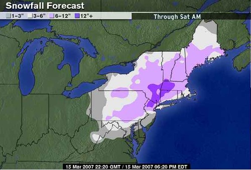
The Weather Channel's current snowfall projections, of which I generally agree, and will be adding a roundup of site-by-site predictions for the Mid-Atlantic this evening, along with analysis and potential impacts to school on Friday as well as Saturday activities.
COULD THIS BE WHAT'S IN THAT POT
AT THE END OF THE RAINBOW?
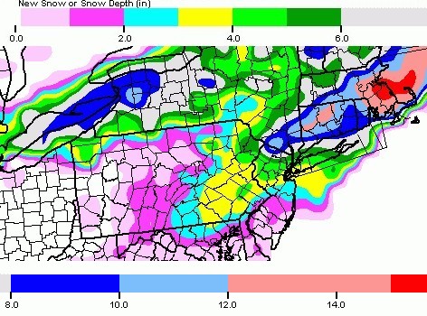
This morning's (12Z) North American Mesoscale (NAM) 84-hour model projection for snowfall this weekend by 8PM St. Patrick's Day. For those of you wanting one more snow, looks like the luck o'the Irish will be with ye. Though the event is 48 hours out as of this writing, the Boston NWS has issued Winter Storm Watches for their forecast area, and everyone who pays attention to this stuff throughout the Mid-Atlantic has begun to hear the first mention of snow in their weekend forecasts. Hard to imagine I'm sitting with the windows open, enjoying what feels like a mid-summer breeze, looking at the current temperature of 71 F, and writing to you about a SNOWSTORM on Saturday. Doesn't get more surreal than that, now does it? My colleagues at school recall that in the days preceding the March 1993 Superstorm (14 years ago this exact moment by the way), they were walking around Baltimore's Inner Harbor in shorts. But even then temperatures in the days prior to that storm were seasonable 50's and 60's. Today at my school, we hit 85 F in the sun and 80 F in the shade, and it was great fun telling students and teachers... "Ready for a White St. Patrick's Day? Har de har har."
As with every Mid-Atlantic and Northeast Storm, this one is bound to be just as complex as all it's predecessors. It has been a busy week and I will endeavor to revise my analysis from the previous post below for this late-season blockbuster which I have maintained since Sunday has the potential to deliver some areas their highest 24-hour snowfall of the year thus far.
REGIONAL SUMMARY Posted 10:02 PM 3-14-07
by Northeastern Forecasting Correspondant Mr. E.H. of Boston, MA.
Overall, it looks like Southern New England and possibly New York City's suburbs will be getting the most snow out of this storm. Those areas will receive their biggest eastern snowfall of the year this weekend and on St. Patrick's Day to boot! However, there will be enough cold air for the Mid-Atlantic once this storm gets its act together off the coast on Friday that areas near or just slighty to the WNW of the cities of Baltimore and DC will see a little wet accumulating snow. Philly and eastern PA may pick up their healthiest snowfall of the season as well with the heaviest snowfall totals to the north.
Into NYC, it looks like there will be advisories and warnings being posted, especially just to their north and northwest. Snow Advisories and Winter Weather Advisories will likely extend all the way down in MD and VA as well. Instability flurries and snow showers will encompass all of the OV and Great Lake states this weekend and will likely deliver a couple inches of snow to this region as well. Eastern TN may even see some accumulating snows this weekend as well! Winter is not over yet.
Into NYC, it looks like there will be advisories and warnings being posted, especially just to their north and northwest. Snow Advisories and Winter Weather Advisories will likely extend all the way down in MD and VA as well. Instability flurries and snow showers will encompass all of the OV and Great Lake states this weekend and will likely deliver a couple inches of snow to this region as well. Eastern TN may even see some accumulating snows this weekend as well! Winter is not over yet.
NORTHEAST SUMMARY: by Forecasting Correspondant Mr. E.H. of Boston, MA.
I am seeing this storm affecting Southern New England (SNE) in 2 rounds.
THURSDAY: ROUND 1. Starts in earnest tomorrow afternoon with rain, moderate to heavy falling along with falling temperatures into the mid 30's by late PM. Rain changes to snow late Thu night and accumulates to the tune of 2-4" Boston metro by the Fri AM rush.
FRIDAY: ROUND 2. Maybe a lull until early PM in SNE then heavy snows move in for the area. Rain on the Cape. Snow accumulating quickly. Late Fri PM, time of the 6 hour period of possible changeover for eastern SNE. Not sure this will happen for areas just WNW of Boston. These areas may be all right for mostly snow. Another 6-10" of wet snow possible with this round.
So, my preliminary forecast is for a general 8-14" of snow for the Boston-Worcester-Providence-Hartford areas by the end of the storm late St. Patrick's Day night.
ANALYSIS: Posted 8:43 PM Tuesday 3-13-07 by Mr. E.H. of Boston.
Snowfall accumulations look to be in the low to moderate Warning criteria for Southern New England. A Winter Storm Warning would be issued in SNE when 6"+ is imminent if the when the Watch was issued at least 12 hours prior and 8"+ is imminent when it is forecasted 24 hours or more prior to the onset.
What I am thinking is that there is a seperate rain maker that moves in tomorrow for Boston and SNE that delivers locally heavy rainfall after highs will range from 70-75 degrees. That lingers as scattered rain showers during the day Thursday with highs in the 50's and dropping by the evening rush. Thursday night there is still spotty showers and a few of these showers may turn to snow showers and flurries, especially in southern NH and VT Friday morning. Then there will be a lull in the action most of the day Friday before the heavy duty snow falling at temperatures of 30-33 moves in. That will continue all night Friday night into the early afternoon hours of Saturday possibly ending as a period of drizzle for eastern SNE. The critical rain/snow line will probably be around Plymouth to the SE portion of MA and RI.
To the north of there, there will be strong NE winds off the nice and cold 37 degree ocean water and with a high parked perfectly over Quebec, enough cold air will be here from Hartford to Providence to Boston for a good sized snowstorm. Still early, but it looks like this type of snow will be very wet with snow to water ratios of 6:1 SE and 8:1 in northern SNE.
Further north into NH, VT, and ME may see ratios of 15:1, but that is where less in the way of snow will fall, the way it looks like at this point. This all moves out Saturday night and we fall rock bottom into the single digits both below and above zero in NNE to teens in SNE. 20 in the cities. Sunday will be the day of digging out if you haven't already or just wait for the sun to do its job. Its almost April for goodness sake...the snow will be melted in a few days!
Nonetheless, highs Sunday and Monday will be quite cold with highs in the mid to upper 30's with breezy NW winds making it feel like we are in the heart of winter again. We stay "cool" until the end of next week, and then it looks like we will warm up the whole country again, back to normal and above normal temperatures. 50's and 60's in the NE...60's to around 70 in the MA.
--end forecast and analysis from Mr. E.H. -- Many thanks for a fabulous and comprehensive overview! I could not have put something together this quality in the time available so the spotlight for this storm is all yours!
For Feedblitz subscribers, in the interests of time and brevity, this post and the one issued earlier in the week are going to be revised with current information. While you'll receive this message in your email, you'll need to go back to the website to receive the most up-to-date details as this and the post before it are going to be updated several times over the next 2 days.