
8PM Friday evening comment: The Mid-March Maelstrom has proven to outmatch my forecasting abilities at present. By the time I will have figured out everything that should happen with our storm, it will already be over. I do feel vindicated in the sense that this was either a good call or a lucky call pegging the time frame for this event 11 days in advance.
(Quote from March 7: "I should also warn teachers, athletic directors and coaches that there is a lot of "March Madness" lurking out there in the 15th-20th time frame and it's not looking pretty. More on that later but let say for now I may have to retract my claim of "That's All Folks" from last month.")
I regret not being able to post my overview of the March 1956 storm, it would have been a great comparison as snowfall from this one will closely match or beat that one. The situation has been so changeable the past 24 hours I didn't feel confident enough to come out swinging with region-wide snowfall forecasts.. but here's what was said or written to a few people including my students either in person or in the comments over the past 2 days: Baltimore: 2 - Dundalk, MD: .75 - Philly: 6 - New York: 7 - Boston: 8. Tonight I'll add Greencastle: 9 - Martinsburg, WV: 10 - Paoli, PA: 7 including sleet - Bucks Co, PA: 11 - Central NJ: 6 including sleet - Fallston, MD: 4.
A special sorry to Mr. B in Greencastle..he had a nice writeup but I didn't post it in time, so I will in the after-storm wrapup. Part of the reason for my lack of progress in updating you on the storm since Wednesday was a time-consuming outdoor landscaping project at our school this week, appropriately timed with the weather of course. I also am a bit behind in an online graduate course, so a lot of mental energy went to those two undertakings. Despite all this, I am glad the forecast somewhat verified in that many members of our online community are receiving their well-deserved (and likely greatest) snow for the season, albeit a bit late. But I am also sad to say this is :::probably::: the last float in the winter parade. Sad in the sense that once we get past this, the website will be going dormant for a while. The quietest time of the year on here is now to about August, or whenever the first tropical system begins to flare and make faces at the U.S. Atlantic coast. Until then, my focus shifts to spring preparations, greenhouse work, landscaping, final exams and closing out school for the year. So enjoy the final hours of your final storm of the winter that's finally done in about 4 days.
Accuweather Radar from this evening. Compare to that of this morning below.
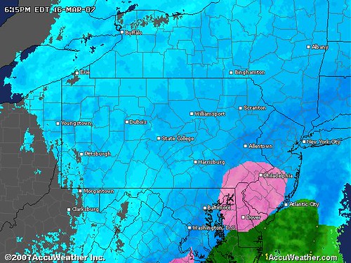
It took a while for the boundary layer to cool, hence the reason your radars all looked pink and white while you only saw rain at the ground. We had a tough time convincing students at our school in southeast Baltimore County WHY we had let out 2 hours early. Though it was raining buckets in Dundalk, the other 2/3rds of the region were seeing rain changing to snow. Combined with the flood warnings, heavy snow potential, sleet and extensive traffic accidents which occured in the morning, those factors were scary enough that school officials apparently decided they had better get ahead of this storm before it got ahead of them. I read in the comments that other districts decided to close outright before hand and for those areas (in WV, southern PA) that was definitely a good call.
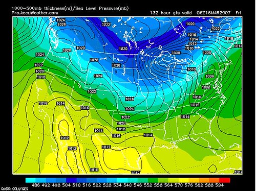
The 8PM projection from the GFS (Global Forecast System) shows the cold air hanging tough despite our vigorous Pre-St Patricks Day Storm rolling quickly up the coast. This is not a current observation map of course but a short range (6-hour) model printout of expected conditions. Note position of the 850 millibar 0 C isotherm... right over 95. I imagine all this sleet is resulting from the strong easterly flow off the ocean crashing right into that cold air, and happening so fast, and with the atmosphere so wet, snow does not have a chance to form. For those who are seeing snow this evening (which appears to be almost everyone but my town).,. your ratios are probably going to be 8:1 or even 6:1, but with 1" of liquid you could still pull 6 inches out of this.

Now, just for fun...here was the original GFS model projection for early this morning, but generated about 6 days ago by the computer. Though the timing is off by 12 hours here, note the interesting differences.. the Great Lakes Low was projected to hang on longer and block the cold air advance to the Mid-Atlantic. The High in Quebec that we see tonight...was nowhere to be found. This is why your local forecasts said nothing of the heavy snow, sleet, grauple, ice pellets, freezing fog, whatever kitchen sink type storm you have there.. because like it or not, Accuweather's 6-10-15 day forecasts as well as the Weather Channel's "The Week Ahead" portion of your local forecast are ALL TIED TO THE GFS. It only began trending colder about 72 hours ago if that. Truth is, the GFS missed the big warmup (84 F in Baltimore Wed) but finally caught on to the colder trend by Thursday.
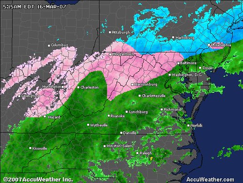
FRIDAY 6:00 AM STATEMENT: My biggest concern with this storm is the cold air is pulled into the Mid-Atlantic region, especially along I-95 and north/west of the cities from DC-Philly, changing the rain over to snow more quickly than expected. This brings winter weather advisories or even instant "Winter Storm Warnings" to areas that were only expecting an inch or two, such as DC and Baltimore. I'm not hypecasting, just thinking that the easterly track as was the trend overnight continues, resulting in a Friday Blitz that leaves your St. Patrick's Day more White than Green. you're in the "Nowcast" Zone now. Forget your local forecasts and just follow the radar today, especially Accuweather as shown above, it will give you the best indication of what is happening at the critical 850 millibar level of the atmosphere where the dynamics may lead to this rapid changeover to snow earlier than later today.
Last point...I THINK THERE IS A STRONG POSSIBILITY MANY METRO AREA SCHOOLS MAY HAVE TO HASTILY SCHEDULE AN EARLY DISMISSAL BASED ON RADAR TRENDS.
(8pm comment: that one worked out well.)