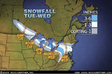
WHAT'S NOT LIKELY TO HAPPEN ON WEDNESDAY: Schools in the eastern Mid-Atlantic (east of the Appalachians) to be delayed, closed or have an early dismissal. (Read: Northern/Central Maryland/Baltimore-DC Metro areas)
Why? Timing of the storm will be such that accumulating precipitation does not arrive in force until mid to late morning. This precip has to overcome a dry atmosphere and penetrating rays of the sun into the clouds as the snow will be primarily a daytime event. The ground will be cold, however liquid equivalent amounts of perhaps .25 for the entire event will be negated considerably by the aforementioned two factors. I can see a situation where it is snowing to beat the band Wednesday morning into the afternoon, accumulating on cars and grassy surfaces. However roads are simply slick and wet. Daytime traffic helps to warm road surfaces, and combined with salt trucks making rounds, this allows roads to remain perfectly fine into the evening rush, thus eliminating the need for schools to close early on Wednesday. Although it will be super cold out there for most of this week, the sun rays will feel strong...because they are! Intensity of the sun angle now is equivalent to EARLY OCTOBER! This same type of storm in early February if you recall delivered a surprise day off on 2/7 for almost all Baltimore Metro area schools, as cold temperatures caused road surfaces to become very slippery on contact with the snow, and sun angle prevented roads from warming. Not this time my friend. I agree with the National Weather Service on this one..expect a light accumulation not to exceed 2 inches in metro areas east of the mountains. Those of you in the mountains, 2-4 inches seems reasonable. You can also check Accuweather's projections and they are fairly similar. Note to Philly area readers: I think your NWS call is off...2-4 inches is much too high and I doubt the moisture can make it that far east or have enough time to pull in from the ocean before storm departs.
There is the outside possibility that upper level dynamics throw us a curve ball, and enhancement of snow banding due to upward motion (along with higher liquid ratios) as was observed in the February 25 event raised snow totals. Just for fun, I'll explore that possibility tonight...but either way..kids or teachers..you're in school Wednesday regardless.

