
ICE, THEN RAIN, THEN ICE,
FOLLOWED BY A COLD WIND
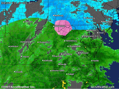
SAT 10PM UPDATE: While the uncertainty of this storm reminds me of the Valentine's Day Massacre of this past February, the precipitation type does not. I love the first comment posted by Terpguy of Baltimore region's TV weathercasters. I can simply the whole arrangement for you quite easily: In my opinion, what your National Weather Service Forecast office has posted is outlined well for this storm, and they seem to have delineated nicely the differences in precipitation type, timing and amounts. It is a complicated storm for sure, but does not have to be difficult to understand at our level. I hope my headline makes the big picture more clear for you. Areas west of Frederick, MD will see the highest precip amounts, mostly sleet and freezing rain versus snow. East of Frederick and north of the Baltimore City/County border, light sleet and freezing rain will give way to all rain overnight. In the larger view, it appears our anticipated secondary low is forming along the Carolina coast, and bringing with it deep moisture already convectively active. For areas at or below freezing which have a pocket of this energy cross over from the warm sector to cold sector, you may be woken tonight to the sound of thunder-sleet or thunder-freezing rain!
Think of it this way...most locations in the Northeast, except for the deep interior mountain areas, will see frozen precip changeover to liquid for a time, all then back to frozen before ending with stiff north and northwest winds on the backside. The intrusion of warm air aloft from a stubborn Southeast Ridge combined with influence of subtropical moisture from Olga's remnants are the main culprits to blame for robbing you of a good snowstorm. At this time, I will only be able to focus on the storm's impacts to the North and Central Maryland/Northern VA, Central and Eastern PA, On Sunday, I will start an analysis of potential impact to the Monday school schedule. I will try to take a look at the impact to our readers in the Northeast and New England.
For everyone in this storm, the one event that seems near certain is a refreezing of all standing water Sunday night, coupled with strong winds creating power outages overnight. A second Arctic High will arrive as the storm departs Sunday, sending temperatures into the 20's across the region, encasing all untreated roads, parking lots, sidewalks and your front step with a glaze of ice. My biggest concern is the school schedule situation for Monday, considering the potential for strong gusty winds, downed power lines, slick roads and widespread icy spots due to the refreezing. Right now, delays seem quite likely from Carroll County, MD east. In areas experiencing the sleet/freezing rain, temps will remain lower and re-freezing occurs more easily tomorrow night, so I could see Northern VA schools closed, as well those in and west of the Blue Ridge.
For everyone in this storm, the one event that seems near certain is a refreezing of all standing water Sunday night, coupled with strong winds creating power outages overnight. A second Arctic High will arrive as the storm departs Sunday, sending temperatures into the 20's across the region, encasing all untreated roads, parking lots, sidewalks and your front step with a glaze of ice. My biggest concern is the school schedule situation for Monday, considering the potential for strong gusty winds, downed power lines, slick roads and widespread icy spots due to the refreezing. Right now, delays seem quite likely from Carroll County, MD east. In areas experiencing the sleet/freezing rain, temps will remain lower and re-freezing occurs more easily tomorrow night, so I could see Northern VA schools closed, as well those in and west of the Blue Ridge.
In the comments, please consider posting a run down of what your local TV weathercasters are projecting, as well as your observations on when precip began at your location, and what type it was. Sunday afternoon, once we see the winds materialize and get a sense of overnight temps, I'll post a final call for schools Monday morning.