
Good thing I kept my expectations low for this morning, as I saw outside what some of you weren't expecting to see...windswept rain in the 40's. But scroll down to the set of 3 maps to see who I think may be coming to dinner.
I see that many location east of the Blue Ridge that were icing last night changed over to rain. While I expected that too (remember the "frozen-liquid-frozen" bit from yesterday), I can still hear the collective sigh from across the lands. It does just seem wrong and sacreligious to have a nice pretty coating of ice get washed away so quickly. So what happened? To put it in simple terms, strong southerly flow ahead of the primary low sent warm air intruding aloft, which overnight worked down to the surface, scouring out the marginal cold air east of the mountains. But from Hagerstown on west along the PA-MD line, surface cold air remained locked in, providing a constant supply of freezing rain. Secondly, Influence of subtropical moisture really revved up the secondary low as some of you observed with the heavy rain overnight.
What looks apparent to me on the national radar is proof of my long standing rule.. the primary low always seems to stay stronger longer. The benefit of that is areas east of the blue ridge are caught in this warm "occluded zone" keeping temps in the upper 30's to around 40. While that's depressing for those of you wanting ice (odd bunch they are) this setup also prevents surface moisture from evaporating. Theoretically, once the primary low decays, cold air will rush in to fill the gap left by it and the departing secondary low. For those in school systems (or elsewhere) wishing to have a delay or closing, we'll have to see rapid refreezing in the overnight hours.
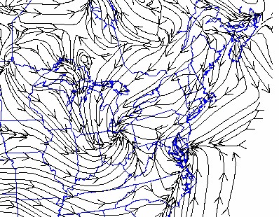
First map is known as Surface Streamlines. Note the position of 2 lows and the counter-clockwise flow. What's interesting is the pull of air from New England and New York into PA on backside of the coastal low... now go on to the next map.
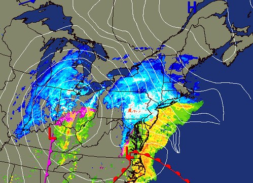
Surface Map for this morning, or view a current animation. Observe how the warmer air is being held to the coast and not intruding across PA, as evidenced by the precip type seen by the radar. Those of you along I-95 or in a blue zone here might say, "Well it's raining at my house but your map shows it's snowing." That rain may have been snow above for a brief time before melting on the way down. For the cold air to arrive, either the secondary low has to pull it in from the north, or the front to our west has to sweep through.
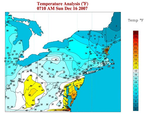
The most interesting observations come from this map. See how the 30's are entrenched across PA, and the 40's are being held to the coastal plain. In fact, look at the contrast between northern and central NJ.. 29 vs. 41. Also note the lobe of 20's nosing down through eastern PA and the depth of near-freezing temps extending through central VA. This tells me there's a slow gravy train of cold air being setup by the developing secondary Low that's taking over air flow as the primary Low decays slowly. Will also be interesting to see how that large area of 40+ is dealt with as cold invades from the west and north during the day.
So who's coming to dinner? For areas east of I-81 in PA, MD and VA...whatever precip you have will changeover to snow showers with strong north winds late, followed by temps in the upper teens in central and eastern PA, and the 20's in MD west of the Bay, 30's east of the Bay. Too early to tell how temps and precip will impact schools, that may not become apparent until very late tonight. Until then, please consider posting your observations IF YOU NOTICE A SHARP CHANGE OVER A SHORT TIME, I think you'll start to see it soon...