
WILL THE FUN BE LASTING?
This forecast graphic just made me smile this morning, and for powderhounds in the area, I'm sure it'll have the same effect. If this pans out, look for a highly disrupted week considering the overnight temperatures. Keep in mind now I use places like downtown Baltimore or Dundalk as my bellweathers... because if warming influences of the urban heat island/bay are not enough to overcome frozen precip potential, then it's a sure bet outlying areas north and west are going to see more. If not "more" they'll at least see generally frozen precip.
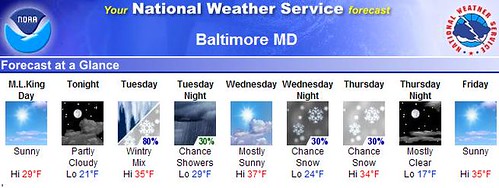
Right on schedule, the Baltimore/DC NWS is coming around to the ideas I originally posted late last week: 3 snow events on tap for the Mid-Atlantic over the next 7-8 days. Now Saturday's Vlizzard could have been counted as one of those 3, so that leaves Tuesday and Wed-Thu as candidates. There is still potential for a weekend system, and if the timing/amounts are right, is there a chance this might deliver TEACHERS as well as students in some school systems (namely Baltimore County) a shot at a 3 day weekend? The answer is: I suspect region-wide accumulations next Sunday would have to be 5"+, or at least fall very late overnight into Monday. Obviously that is too far distant right now for any solid projections, but the potential is there and I'll be watching it carefully.
Final note: Very busy today trying to get grades, paperwork done along with attempts to resurrect the "forecast computer." I may have spilled some water into the laptop's wireless port (of all the dumbest places!) and now, the laptop just sits on my lap and hums. It is not a pretty tune, so I'm hoping our President will deliver on his promise to send us all bonus money borrowed from China that I can use ot help stimulate the economy. (Just don't tell my wife!)Anyway, will try to respond to your comments as time and family permit.