

Pardon the anthropomorphism, but I believe the atmosphere is revealing clues to us on what's really going to happen, and I am trying to pin them down. A well-known forecaster at Accuweather made the point earlier today of a striking similarity between what is about to happen and that of the 3 day period prior to the Feb 03 Blizzard (insert reassuring statement here that neither he nor I are forecasting a blizzard). It's quite simple. Friday night into Saturday Feb 14-15, there was front runner clipper that brought 2-4 inches to the central Mid-Atlantic, and was all done Saturday night. Most of the public who were enjoying their President's Weekend weren't paying close attention, and went to bed Sat night thinking that was it. (Including me) The clipper brought in the Arctic High, the moisture gathered from the Gulf Coast and ran right into the High. Sunday morning we awoke to what no one expected: moderate to heavy snow falling in very cold temperatures. The high departed slower than we thought it would, the easterly fetch kept pumping in Atlantic moisture added to the tremendous surge of Gulf moisture already in place, and pow! Two feet later, the rest is history. Now, given that history lesson, look over the storm synopsis from a long time reader, Mr. E.H. of Boston, and let us know what you think.
SYNOPSIS OF WED-FRI STORM IMPACTS ON MID-ATLANTIC AND NORTHEAST submitted by long-time reader E.H. of Boston, MA.
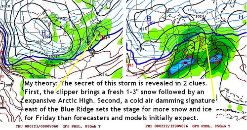
STORM 1: THE MID-WEEK CLIPPER. This first system comes in Wednesday from the Ohio Valley streaking towards Pennsylvania, Maryland and Virginia. Snow will break out from DC to north of Philly as the center of the Low passes over central VA. I would expect a heavier band of snow somewhere from BWI-PHL-SNJ. Overall, I'm thinking a quick hitting 1-3" here with a few 4" amounts embedded outside the cities. A classic 1-4" clipper despite potentially low moisture amounts to start.
Then we watch the developing second system in the southern Gulf States. A southerly flow will try to ride over a fairly substantial cold air damming in place and this will allow for overrunning snows to take the place of the departing clipper snows in the Mid-Atlantic. Some may not even notice the switch from clipper snows to overrunning snows :)
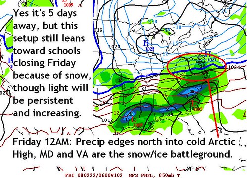
STORM 2A: MID-ATLANTIC OVERRUNNING EVENT. Snow will streak up from Tennessee toward the I-95 corridor Thursday night before turning over to rain Friday in the cities and coastal areas, while staying sleet/freezing rain just northwest of the cities, where some significant icing will take place. Before the changeover, I could still see a couple inches accumulate, bringing an accumulative snowfall from WED-FRI averaging around 3-4"
STORM 2B: INTO THE NORTHEAST (Continuation of STORM 2A, just further north) As the Mid Atlantic's major cities start to transition to rain, we will see NYC and Providence-Boston get into the action. Snow will streak into the region from the southwest as we head into Friday night and Saturday could yield a snowy day. I am not saying heavy snows, but a moderate accumulation, perhaps a 3-6" snowfall for Southern New England with maybe closer to a 4-8" snowfall north of NYC. Not a major event, but a winter event nonetheless as I bask in 60 degree warmth while writing this in Boston.
OVERVIEW: Snow Wed PM in DC-BWI-PHL-SOUTHERN NJ. Heaviest from BWI-PHL. General 1-3", isolated 4". Late Week MESS Mid Atlantic. Snow to Ice to Rain (SE). Light Snow Accumulations Possible. Significant Icing Interior. Northern PA/NY State/New England Snow Friday PM - Saturday. Moderate Accumulations Possible. (Editor's note: Much appreciation to E.H. for putting this together, he and I have seen many a storm go WAY farther north than was orginally projected, so I'm leaving the calls for southern New England there.)
THE ON-AGAIN, OFF-AGAIN STORM IS ON AGAIN
8 AM MON 2/18: Today, I won't argue with anyone who wants to label me a "model hugger" in the sense that it comes across I'm just shifting my positions based on every individual model run. I normally follow the US generated Global Forecast System (GFS) and the European (ECMWF), to get an idea of general trends. Last night both were showing total suppression of precipitation to the Carolinas for Thursday into Friday. A professional meteorologist, Mr TQ, whom occasionally comments here, has helped set me straight that we are indeed dealing with a negative NAO middle to late next week. However, it seemed that the models were also just suppressing the precipitation too far south too quickly. Regardless of what was being projected, I felt the large scale dynamics were (and still are) going to produce an over-running event. Sure enough, that's what the overnight models came out with, as shown below.
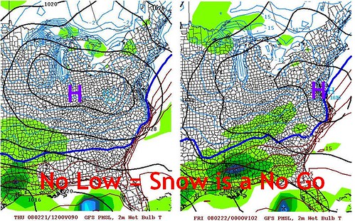
SUNDAY 2/17 PM: I am providing the other side of the discussion, in the event this bears out come mid week. Above was the Sunday night GFS projection for Thursday and Friday. As you can plainly see, very little if any precip in the Mid-Atlantic for that period. Except for the yellow mark over Baltimore that'll represent egg on my face if there's no storm. The strong 1040 mb high coming behind the current storm moving through the Great Lakes looks to charge southeast according to many models. (That was the overall thinking Sunday night).