

STORM OVERVIEW: This outline will be revised as information and indicators change, but it represents my present thinking for the Mid-Atlantic states for central VA - Maryland - central PA to New Jersey.
WHEN? Arriving in MD and VA Thursday between 3PM and 9PM. Starts light and intermittent, increases in intensity but will alternate between light and heavy due to waves of low pressure moving along a frontal boundary.
HOW LONG? Majority of precipitation will exit the region by Friday night.
WORST PART? Overnight Thursday until Friday afternoon.
HOW MUCH? If precip remains all snow AND if it trends more north than models currently indicate...then 4 or more inches for central/northern Maryland, central/northern Virginia (4 or more in a 12 hours is NWS Criteria for Heavy Snow) If freezing elements mix in, snow amounts will be cut down closer to 2" and sleet/freezing rain could account for at least 1/2"
SCHOOL? Given the current timing ideas, I would project many schools in the affected areas of Maryland and Virginia closed Friday. An earlier arrival time could interfere with Thursday.
Note: Will be adding a revised surface map to show differences in model projections from this past Friday to today, so we have something from which to base our discussions.
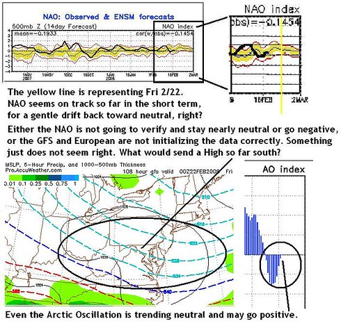
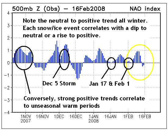
NAO Indications prior to February 2003 Blizzard: Although the NAO was slightly NEGATIVE and trending toward neutral, this slight drift occured in the 2 day period just before and THEN during the storm. My theory is that was a major factor which enabled the primary Low and it’s moisture to “over-run” the High toward the Mid-Atlantic. A strong negative trend in the NAO means Arctic air will overwhelm the region and keep storms south or out to sea. PLEASE NOTE I AM NOT SAYING THIS STORM WILL RESEMBLE FEB 03, I am saying the early indicators are somewhat similar to what was seen prior to that storm and I am showing you those for discussion purposes.
Also of note is that the NAO during Winter 2002-03 spent most of the time neutral to negative, but not significantly so. In recent years, very strongly negative NAOs over several weeks correlated to extensive cold periods, and strongly positive NAOs led to unseasonal warmth. You can see from the chart below that this winter we have not even observed a standard deviation beyond 2, and winter for the Mid-Atlantic has been relatively quiet in comparison to years like 02-03 or 05-06.
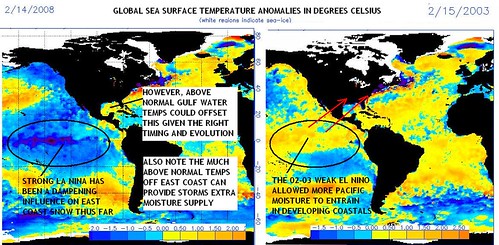
2. SEA SURFACE TEMPERATURE ANOMALIES: THE CANARY IN THE COALMINE?
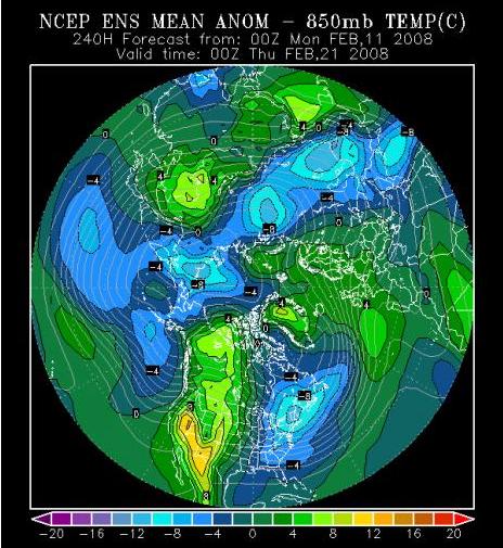
3. UPPER-AIR TEMPERATURE PROJECTIONS: COLDER DAYS ARE COMING UP
Below is the 850 millibar GFS Ensemble map for the Northern Hemisphere, produced 2/16 for 2/21. It clearly shows a 4 to 10 C degree negative departure at the boundary layer (5,000 foot level) over the entire Mid-Atlantic and Northeast starting Thursday, indicating that a cold and expansive High will be parked somewhere nearby. What significant is the "ensemble" is not one single computer model but a compilation of all the different algorithmic scenarios that computer has projected, and merged into a single "averaged" solution. If the average solution is noticeably below normal temperatures right at the onset of our storm, then a lot of forecasts for rain could bust big. Just think...if at 5,000 feet above Baltimore next Wednesday night the temp is already 6 to 8 degrees C below normal, if that ends up being around -15 F at those levels, it would favor the development of dentritic snow crystals. Those are the fastest to form with the highest fluff factor, and lead to high accumulation rates as was observed in February 2003. Too soon to say if that would happen, but the temperatures at least look good so far.
THE BLIZZARD OF 2003: 5 YEAR ANNIVERSARY. For a trip down memory lane, review this article in Wikipedia about the Great North American Blizzard of February 2003, which started 5 years ago, right about now. If you have extra time, take a look at this slideshow I have on an old webshots site from the storm, it makes me feel like I'm still there. Enjoy the memories, I wonder when we'll get to make some new ones like this.