Blizzard To Rock Northeast Coast
Pressure projected to drop 40 mb in <24 hours
"All we want is life beyond the Thunderdome..."
Pressure projected to drop 40 mb in <24 hours
- BLIZZARD WARNING for CAPE COD & EASTERN MAINE
- CHECK IN WITH OUR MASSACHUSETTS ZONE for METRO BOSTON & THE CAPE
- SECOND YEAR IN A ROW FOR I-95 SNOW ON MARCH 25
- RETALIATE AGAINST THE SNOW WITH 25% OFF RAINBOW HOODIES!
"All we want is life beyond the Thunderdome..."
- Tina Turner in the 1985 Soundtrack of Max Mad Beyond Thunderdome
12:25 PM 3/24 - RETURN TO JANUARY-LIKE COLD UNDERSCORES CONCERN FOR POSSIBLE ACCUMULATING SNOW IN NORTHEAST CORRIDOR TUESDAY INTO WEDNESDAY. An overview of expected conditions for the inland Mid-Atlantic:
TUESDAY – The major coastal storm will spare most metro areas from Philadelphia south from worst impacts, which will be felt in coastal communities from Ocean City, MD to Delaware, southern & central New Jersey to southern New England.
TUESDAY – The major coastal storm will spare most metro areas from Philadelphia south from worst impacts, which will be felt in coastal communities from Ocean City, MD to Delaware, southern & central New Jersey to southern New England.
- TIMING & EFFECTS: For much of the Northeast Corridor, snow is expected on Tuesday, starting in the daybreak hours south of the PA/MD line, and by mid-day for PA and NJ. However, with the strong March sun, this snow will have difficulty accumulating, especially considering that available liquid is generally 0.30" or less except along the immediate coast. We may also have temperatures near or slightly above freezing, which means that not all snow that falls will stick. Winds will pick up in intensity throughout the day, and some NWS offices have indicated the need for Wind Advisories as gusts may exceed 35 mph over large areas.
- ACCUMULATIONS: 4" or more are possible for the interior northeast into southern New England. For the I-95 metro areas of the central mid-Atlantic, perhaps a coating to an inch in most of Baltimore/Washington/Philadelphia but confined to grassy/colder surfaces, with roads mainly wet by 8 AM Tuesday. Coldest rural areas may see up to 2" where roads are untreated and snow falls uninterrupted for several hours.
- TUESDAY NIGHT – Some snow showers may be possible, but otherwise we expect clearing skies with lows falling back to the low to mid 20s. Winds will stay gusty from the NW at 25 mph or greater into the overnight hours and decreasing by morning.
- WEDNESDAY – Windy conditions are expected across the region in the morning, gradually improving later in the day. Highs are still only expected in the upper 40s.
(previous reports below from this past weekend)
11:15 AM 3/23 - For those hoping there has "got to something better out there" in terms of the long range pattern, we DO have good news! Look below the storm report for a glance at the Long Range temperature outlook.
- MAJOR COASTAL LOW TO PRODUCE GALE FORCE WINDS ALONG MID-ATLANTIC SHORE, WITH WIND WHIPPED LIGHT SNOW FOR INLAND AREAS.
- SNOW PROBABILITIES OF 4" OR MORE RISING FOR INTERIOR NORTHEAST SKI RESORTS AND SOUTHERN NEW ENGLAND.
- REGIONAL STORM, LOCAL IMPACTS: The next "castle built in the air" (to quote Ms. Turner's lyrics) will be by next Wednesday a raucous time of strong winds, coastal erosion and potentially heavy snow for the coasts of Mid-Atlantic & Northeast.
- WORK THE STORM WITH OUR TEAM! We have forecaster stationed in several states that will be most affected by this storm, including our Bayshore zone of the MD Eastern shore and Central New Jersey to our Metro NYC and Massachusetts zones. If you live in these areas or know of someone who does, please send them along to our forecasters there for authentic local reports from the FF team!
- WHAT'S BEYOND THE THUNDERDOME? After this one-two post winter punch (of a major coastal Low, then a brutal Arctic High), the 6-10 day temperature trends show a rise to near or above normal for much of the country starting the 1st week of April -- as shown below.
For additional analysis on the storm, please continue reading below
FROM THE WINTER STORMCAST TEAM - As posted in our Central Maryland zone page earlier today regarding our analysis of NOAA data and projections:
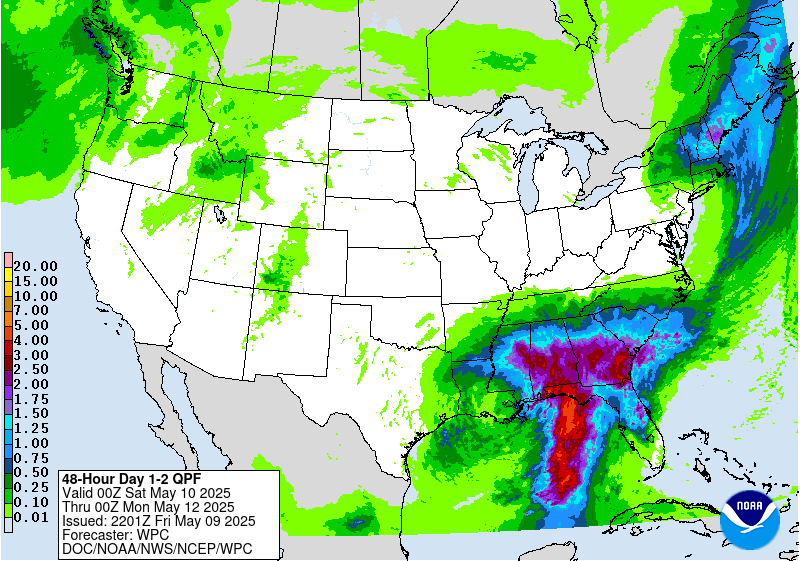
1) PRECIP PROJECTIONS. These are a meteorologist-prepared map based on an assembly of latest model input. The latest map shows "the blue line" of potential liquid uncomfortably covering a good portion of MD already, and edging near the I-95 corridor. Coastal areas are right against the 0.75-1.00" line.
This is the 0.50-0.75" line and being near that is something to watch. You can look at this map and read between the lines of the NWS in their current Hazardous Weather Outlooks to see why they are concerned
2) PREDICT THE HIGH, PREDICT THE STORM? This time the High looks to be drifting off the New England coast as lows will be crawling along or off the eastern seaboard. The concern is a double barrel easterly flow that will be countered by the arrival of chillier air from SE Canada at the same time. Not the classic nor'easter setup, we agree, but the winds will be fierce enough to warrant Gale or even Storm Warnings if they range above 39 MPH.
The problem is too much easterly flow CAN have the effect of driving a surface low just a few miles closer to the coast, and voila! What was going to be a miss to the east adds another snow day to the winter-abused calendar.
3) IS IT ALL OR NOTHING? The real issue is OVERNIGHT TIMING. No matter your location in the Mid-Atlantic or Northeast, if bulk of the precip arrives overnight Tuesday into Wednesday when cooler air is filtering south, there is only 1 time question that matters: What is the weather at 5:00 AM Wednesday morning? Thankfully we have a long time to watch this.
SNIPPETS FROM NOAA - This morning's statements from several source we follow closely to unpack their investigations for repurposing to the public:
- MODEL DIAGNOSTIC DISCUSSION - WPC (FOR MON-TUE) "THE UPPER PATTERN BEGINS TO STRONGLY AMPLIFY ENTERING THE BEGINNING OF NEXT WEEK WITH A LARGE POSITIVE HEIGHT ANOMALY SETTING UP ACROSS THE WESTERN U.S. ALONG THE WESTERN EXTENT OF THE BROAD CYCLONIC FLOW ACROSS THE NORTHEASTERN PORTION THE CONTINENT WILL BE A RATHER WELL-DEFINED SHORTWAVE WHICH WILL RACE FROM THE DAKOTAS INTO THE LOWER MO/OH VALLEYS BY EARLY TUESDAY. THIS FEATURE IS OF SIGNIFICANT IMPORTANCE AS IT IS THE PRE-CURSOR TO THE COASTAL SYSTEM EXPECTED INTO THE EARLY MEDIUM RANGE PERIOD."
- EXTENDED FORECAST DISCUSSION - WPC: (FOR WED) " BY EARLY WEDNESDAY MORNING, A SUB-970MB SURFACE CYCLONE IS LIKELY NEAR THE BENCHMARK AFTER THE BOMBING PHASE. HOW FAR SOUTHWEST THE BOMBING OCCURS IS CRITICAL FOR THE SENSIBLE WEATHER FROM THE CAROLINAS TO NEW ENGLAND. THE EARLIER/FARTHER SOUTHWEST, THE GREATER THE CHANCES FOR SIGNIFICANT WINTER WEATHER FROM THE CAROLINAS AND SOUTHERN MID ATLANTIC ALL THE WAY THROUGH MAINE. IF THE BOMBING IS LATER / FARTHER NORTHEAST, EASTERN NEW ENGLAND WOULD SUFFER THE WORST EFFECTS. EITHER WAY, WINDS LOOK REMARKABLY STRONG ON THE WEST AND SOUTH SIDE OF THE TIGHT CIRCULATION TUESDAY NIGHT INTO EARLY WEDNESDAY--A MAJOR CONCERN FOR COASTAL AND OFFSHORE INTERESTS FROM EASTERN LONG ISLAND TO DOWN EAST MAINE."
- AREA FORECAST DISCUSSION - NWS BOSTON/TAUNTON (FOR TUE-WED) "CONFIDENCE IS INCREASING IN A SIGNIFICANT WINTER STORM FOR AT LEAST SE NEW ENG LATE TUE INTO EARLY WED. WE EXPECT ACCUMULATING SNOW FOR MOST OF THE REGION...BUT GREATEST IMPACT FROM THIS STORM TRACK OUTSIDE THE BENCHMARK WILL LIKELY BE FELT ACROSS SE MA AND ESPECIALLY THE CAPE/ISLANDS TUE NIGHT INTO EARLY WED WHERE HIGHEST PROBABILITY OF HEAVY SNOW AND STRONG WINDS ARE EXPECTED. WE INCREASED POPS TO LIKELY SE MA AND CAPE/ISLANDS. HOWEVER...WE ARE STILL 4 DAYS OUT AND ANY CHANGE IN THE CURRENT STORM TRACK WILL IMPACT WHERE AXIS OF HEAVIEST SNOW OCCURS."
IN SUMMARY, with the strong potential of a major coastal storm still in play, we advise not dismissing early indications "the low will track east" because in reality, not even the top mathematicians and meteorologists know where the precise track of this storm will be four days out. All we can do is sift through the data and find as many indications as we can of where the storm will go, and report what we learn hear when we learn it.
AND FINALLY, if you just want "Life beyond the Thunderdome" here's a soundtrack video for the Tina Turner fans from the 1985 classic:


