
What Can You Do?
Stay calm. Be Patient With Others. Prepare. Communicate. Get Rest.
EXCELLENT WINTER STORM SAFETY CHECKLIST VIA THE CDC
EXCELLENT WINTER STORM SAFETY CHECKLIST VIA THE CDC

11:30 AM EST 1/21 STORM TIMING & IMPACT SUMMARY

6:20 AM EST 1/21 (Winter Stormcast Team Statement) The Mid-Atlantic and surrounding region is less than 48 hours away from what could be a historic snow for millions. Granted, those in the upper Northeast, Rockies and other snowy places might say, "2 feet? That doesn't even close school where I come from."
- BLIZZARD WARNINGS posted for the I-95 CORRIDOR FROM WASHINGTON TO PHILADELPHIA AND THE UPPER EASTERN SHORE for 12-18" of snow near and along the Chesapeake Bay. 18-24" for inland areas north and west of I-95.
- Higher amounts are possible in areas where the heaviest snow bands develop.
- This will be an extremely dangerous and life threatening storm.
- Please make the necessary preparations to protect your family and property.
FORECAST OVERVIEW: ALONG & WEST OF I-95 TO THE BLUE RIDGE & NORTHERN VIRGINIA & SOUTHERN PA. AREAS OF THE EASTERN SHORE IN NEXT SECTION.
Please consult your NWS point and click forecasts for the latest official statements.
Please consult your NWS point and click forecasts for the latest official statements.
- TODAY & TONIGHT - Cold and mostly clear with highs 30-35 F, lows near 20 F. NWS Image below is from Rockville MD as a representative location.
- For anyone south of the PA/MD line, this is a general overview of what to expect for Friday. We believe dry air should negate the first few hours of snow other than Northern & Central Virginia. If you are north of MD or on the Eastern shore, snow is not expected until after 6 PM Friday.
- FRIDAY - AM Flurries followed by occasional & scattered light snow between 12 - 4 PM. Accumulating up to 2" by 8 PM. Snow becomes heavy after sunset, with up to 12" possible in many areas by daybreak Saturday.

- SATURDAY - Heavy snow throughout the day, winds 35 mph at times with higher gusts. Snowfall of 20-24" will be common throughout regions under a Blizzard Statement or Winter Storm Warning. Travel will become impossible. Periods of extremely heavy snow are possible 12 PM - 6 PM due to explosive development of the Low pressure expected along the Bay.
- Widespread power outages are expected. Do not try to walk the dog because it looks like things are clearing up. You may not come back alive from the walk. We are always terribly saddened to read about that in the news. Please keep your children in your eyesight at all times. Reading a book is far better than the alternative.
- SUNDAY - Snow should begin tapering by morning with winds remaining at 15-25 mph and higher gusts until afternoon.
We will work the storm with you and send our warmest wishes for your safety in what will be a most difficult time for everyone affected.
From all of us at Foot's Forecast
6:20 AM EST 1/21 (Winter Stormcast Team Statement) The Mid-Atlantic and surrounding region is less than 48 hours away from what could be a historic snow for millions. Granted, those in the upper Northeast, Rockies and other snowy places might say, "2 feet? That doesn't even close school where I come from."
But in the metros of Gotham, it is a different story. Put 24 hours of snow on top of millions of people in close proximity and... well, we can leave it there for now.
We have prepared this storm summary with some safety recommendations to follow from the good folks at NOAA and Homeland Security. First, our preliminary snow map:
We have prepared this storm summary with some safety recommendations to follow from the good folks at NOAA and Homeland Security. First, our preliminary snow map:

WHAT'S THE LATEST?
A BLIZZARD WATCH has been posted for the entire
Central Maryland and Northern Virginia region with Winter Storm Watches for the surrounding areas. This means there is even more potential for serious and life-threatening impacts, including property
damage.
- Strong onshore winds will accompany the heavy snow bringing an increasing potential for power outages with the weight of the snow on power lines and tree limbs.
- Serious travel hazards will remain throughout this storm. Make sure your family has what it needs to stay safe and well-prepared in this storm.
- We expect a swath of 16-24" inches over much of the Baltimore/Washington metro region, extending to the WV panhandle, northern Virginia into southern & SE PA.
- Where heavier bands may develop, and in more rural or mountainous areas, the potential exists for 30 inches and perhaps more..
- To the south, we expect 10-16 inches for much of Southern Maryland, with slightly lower totals for the far southern tip
- For the lower Eastern shore, 6" is possible along the coast and 12"+ inland
WHERE IS THE STORM?
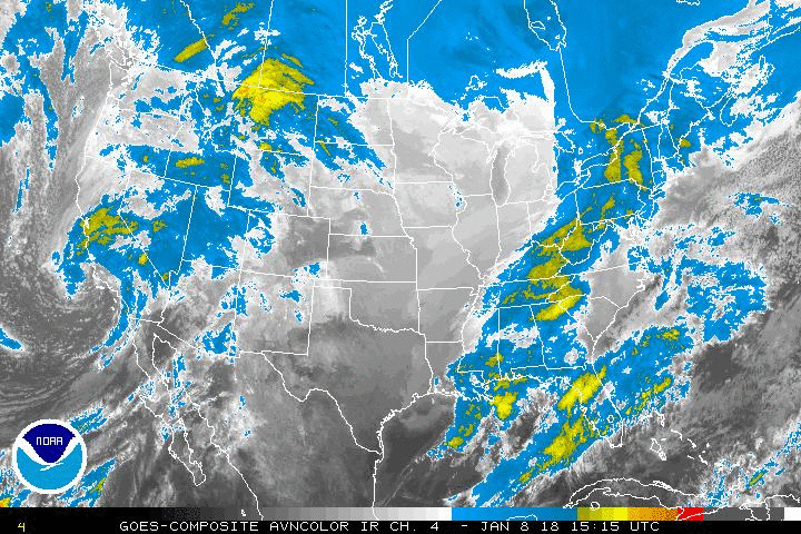
WINTER STORM SAFETY
Currently developing in the central Plains as seen here. Take note of the extensive plume of moisture coming up from the Gulf of Mexico. That actually connects clear back to the Equator, which is why there's such intense potential for heavy snow.
WINTER STORM SAFETY
From the NOAA Winter Weather Safety Site: "Your primary concerns at home or work during a winter storm are loss of heat, power and telephone service and a shortage of supplies if storm conditions continue for more than a day." - NOAA

RECOMMENDED WINTER STORM SUPPLIES
- Flashlight and extra batteries
- Battery-powered NOAA Weather Radio and portable radio to receive emergency info
- Extra food and water such as dried fruit, nuts and granola bars, and other food requiring no cooking or refrigeration.
- Extra prescription medicine
- Baby items such as diapers and formula
- First-aid supplies
- Heating fuel: refuel before you are empty; fuel carriers may not reach you for days after a winter storm
- Emergency heat source: fireplace, wood stove or space heater, properly ventilated to prevent a fire. NOT CANDLES OR INDOOR KEROSENE heaters
- Fire extinguisher, smoke alarm; test smoke alarms once a month to ensure they work properly
- Extra pet food and warm shelter for pets
- Review generator safety. You should never run a generator in an enclosed space.
- Home fires are common each winter when trying to stay warm. Review ways to keep your home and loved ones safe before, during and after the storm.
Our next update at 11:30 AM to revisit computer model projections.