
This week will be a study of contrasts...near-recording breaking warmth into Wednesday, and perhaps record-breaking snow on Thursday and Friday. The trick will be that this series of events is going to occur in the same exact places: All the major cities and interior sections of the Northeast United States. By Friday, the warmth of Monday will seem like a long time ago.
If you thought the final moments of the SuperBowl were down to the wire, then wait until you see how your local forecasts are going to change this week... I think you're going to see a Hail Mary lead to a major late-game interception by the European model on Thursday, and run this storm to the end zone for the winning touchdown on Friday.
FIRST, JUST THE WEATHER
FAT TUESDAY: Mild and pleasant conditions continue. Almost everyone you know will wonder aloud if winter is over, and start cracking jokes about how uneventful of a winter it "was." Sunshine and warm temperatures will abound throughout the Northeast, with highs near 60 from Baltimore on south, and mid 50's from Philly north to Boston. A cold front will approach from the west on Tuesday night.
WEDNESDAY: This is the day everything begins a rapid shift back to winter as we know it. As the cold front passes, temperatures will start to trend down and overnight into Thursday, light rain showers will change to snow showers throughout the Mid-Atlantic.
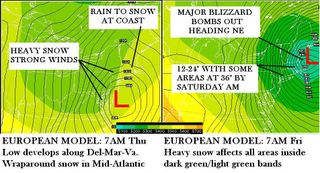
THURSDAY: A low pressure system will develop along or near the Virginia Capes/Mouth of the Chesapeake Bay, deepen rapidly as it moves north-northeast. If this occurs, mixed rain and snow showers will increase in intensity from southwest to northeast...first affecting Baltimore by noon, then Philadelphia in the early afternoon, New York City and Long Island by nightfall. Accumulations will be around 2" in southern Baltimore County, 4" from the Baltimore Beltway on north and east to Philadelphia, which could also see 4-6" with higher amounts north and east. More details available in the Storm Analysis Section below.
FRIDAY: This storm is now Big Kahuna 1, and continues it's slow northeast movement toward the New England coast, turning into a major snowstorm with blizzard conditions from New York City north and east to the coast of Maine. Accumulations will range from 12-24" in interior New England east of I-87, west and north of I-95.
STORM SUMMARY: This storm will end up being stronger, colder, snowier as well as affect areas further south than originally forecasted by the NWS, what you see on your local TWC forecast, or your Accuweather 15-day forecast. I explain why below
STOP HERE if this is enough information for you. BE FOREWARNED that scrolling further through this post will result in being exposed to more scientific analysis gobblygook.
TUESDAY UPDATED STORM ANALYSIS FOR KAHUNA #1
SUMMARY: Arrival time of this storm will be Thursday 5AM from DC to Baltimore, LATE MORNING for Philadelphia-New Jersey, by early afternoon for New York and Long Island and into the by late afternoon for Southern New England. This forecast makes the assertion that the coastal Low will develop along the southeast Virginia Capes as opposed to the Delaware or New Jersey coast, resulting in higher snowfall accumulations for the Mid-Atlantic than originally anticipated by the National Weather Service forecasts. Precipitation will begin as rain in the I-95 metro areas , and a rain/snow mix in northern and western suburbs of those cities. Cold air drawn in from the north will change all precip over to snow by late afternoon if not sooner.
AREAS NOT IMPACTED: North Carolina. Areas of Maryland/Virginia north and west of I-81. Central and Western Pennsylvania north and west of Harrisburg. Central and Western New York from Binghampton on north and west.
1. TIMING: Thursday is the critical day for the Mid-Atlantic, and Friday for New England. Computer models are having a difficult time resolving how the surface Low pressure systems interact with an eastward rotating upper level trough. Indications are a tertiary Low develops near the Virginia coast, and deepens rapidly heading northeast. The relatively slow movement of this storm is the rationale behind why this will become a paralyzing, life-threatening situation for almost all of New England. The Mid-Atlantic should be clear and dry by Friday, and the New England by Saturday morning, but both areas will have strong north-northwest winds in the wake of the storm with blowing and drifting snow.
2. PRELIMINARY SNOWFALL: I reserve the right to modify these numbers accordingly until 24 hours before the event begins, and then I'll issue a final "storm grade" amount for locations in my accumulation areas. These numbers undoubtedly seem extreme to you, but they represent the overall scope of what I believe this storm is capable of producing given the pattern and our recent experiences with rapidly developing snowstorms. Yes, I realize none of your TV outlets are talking about this, because they are waiting for the computer models to resolve on a solution. I believe intuition, experience and courage is just as important as waiting for a computer to tell you what to do.
Baltimore Metro to the PA line: 2 - 4" is possible by Thursday afternoon, with locally higher amounts north and east of the Beltway. I have a sense that amounts could go much higher if we see development of the coastal low occuring at the Virginia/NC coast and not Del-Mar-Va. The local NWS office will probably be last to come on board with the big storm idea. Local TV forecasters are going to be all over the place with this one right to the last minute. A Marty Bass Alert has once again been issued.
West Virginia panhandle: 2 - 4" in the first phase of rain changeover to snow, lingering snow showers during coastal redevelopment could add another 1".
South Central and South Eastern PA: 4 - 6" Mixed rain and snow will start the day on Thursday, but as the coastal Low pulls in colder air from the north, bands of heavy wet snow will rotate into the region for the second part of the day and into the evening. This is for areas from York County East to Delaware County. Your area is split between two NWS offices, State College for the west, Philly for the east so statements from them will differ on the outcome of this.
Northeastern PA, Northern New Jersey, N and W of New York City: 4 - 8"
Metro Philadelphia/New Jersey: 3 - 5" with locally higher amounts. Rain will be first on tap, as the warmer east winds at first will hold off any snow. As the storm moves north, wrap-around snow begins, am hesitant on this call because something tells me the amounts will end up being higher. I also felt that way before making the original 6-8" call for Boston 3 weeks ago, and had to ramp that up to 30" which still fell short as some locations received up to 38"
Southern New England (CT, Rhode Island, Long Island): 10 - 18" by Saturday morning. Blizzard conditions. You know, the usual mid winter snowstorm. The potential for higher amounts exist depending on speed and strength of the Low.
Southeastern New England including Boston Metro area: 12 - 20" Near-blizzard conditions by Friday morning. I know you probably don't believe me, but would you have if I said that same thing on January 18 for the 22nd-23rd?
Northern New England (Eastern Upstate New York, Vermont, New Hampshire, downeast Maine): 4 - 8" and near-blizzard like conditions due to strong winds.
3. TRAVEL / SCHOOL: If you are planning to travel at anytime between Thursday 7AM and Friday midnight anywhere in the Northeast from DC to Maine, I would be prepared to make last minute alterations to your itinerary. I think this will be a tough forecast for many agencies and TV stations. I have the sense that given so much uncertainty about other factors...this might be one of those situations where you go to bed Wednesday night thinking "looks like it's not going to be a big deal, all the TV people are downplaying it." Then you awake Thursday morning to dire predictions of a major storm, with Winter Storm Watches all over the place, etc. If it turns into the monster like some computer models see, then no school Friday for most of the Metro Northeast. Maryland and PA schools would be impacted on Thursday if the secondary develops near Virginia instead of New Jersey.
FINALLY, A RATIONALE FOR THE FORECAST
A revised version of my analysis and the explanation for why my forecast goes against what many NWS offices are saying, follows after dinner. Unlike the government, TV forecasters and the private weather industry...I am volunteer forecaster. I can say what needs to be said about the weather because there is no legal consequence for me. That does not mean I will be knowingly irresponsible. It does mean that if my forecast turns out totally wrong and the storm completely fizzles, I'll explain why it did, and will not make excuses or blame computer models. You have my word on that. But it is your choice to adopt or reject my forecast based on the evidence presented.
1. STUDY THE PAST...RECENT PAST. What have we learned from snowstorms this winter? Since mid January, every storm which affected the Northeast Corridor from Washington to Boston has turned out more extreme than anticipated. The public has been caught off guard more times than they would prefer.. in DC each of the 5 previous precipitation events have been SNOW. The rain you’ll see on Tuesday and Wednesday in the Northeast is the first time you’ve had actual rain reaching the ground since I’m not sure when. Think about it… in this supposed warm pattern, each time you’ve had precip, it has been SNOW since the pattern change around January 15.
2. OBEY MARGARET THATCHER'S RULE. "Trust, But Verify." The European was THE model that nailed the First 2005 New England Blizzard, while most forecast offices followed the GFS and pooh-poohed the Euro. I see the same thing happening again. Initially guidance came out from HPC on Friday or Saturday stating that offices should follow the Euro. Now they've backed away from it, and were waiting to see the GFS make up the difference. Now that it has, NWS offices are leaning BACK on the GFS since it has now trender similar to the Euro. Almost as if to use reverse psychology and say that since the two models are similar in the storm solution, this lends MORE credibility to the GFS model.
No one, except for the Boston NWS, wants to jump on board with the ECMWF model. They hint at it, they dance around it, but are avoiding that third rail like the plague. Maybe it’s simply too embarrassing to admit that the GFS will have struck out twice in LESS than 20 days on two major blizzards for the Northeast? Or maybe HPC wants to show that the GFS can nail a big storm like this to silence the critics, such as people like me. I know you think all this yammering about computer models is pretty much useless, but it is a key bone of contention among private forecasters, since the government holds all the strings on this puppet. So from a semi-Libertarian perspective, freedom of information about the weather is why I do this site.
3. THEN AGAIN, OBEY MARGARET THATCHER'S RULE. On the other hand, maybe there is a gremlin at the gates, and the European model is simply too darned aggressive with this storm? That’s why you see many TV forecasters and NWS offices holding back and not throwing all their eggs in that basket just yet. So I do understand the gov't resistance to going ballistic with just one model solution. Those night shifters at Boston NWS must have had too much coffee to go into orbit last night with their forecast discussion, but in verification, their idea still have merit.
4. IT'S ALL PHYSICS. I know you might think I’m bipolar for putting out a 12-24” call in the Northeast. The reason I have decided to go with the gutsy call of something like that is simply physics. Each action has an opposite but equal reaction, right? The abnormal warmth now should be followed by abnormal cold later. I believe that the GFS and NAM models are misreading the strength and chill of the cold air that will be tapped by this storm once it winds up. Has that happened before? Never!
5. PATH OF LEAST RESISTANCE. A large area of surface Low pressure forecasted to be in the Virginia-North Carolina vicinity. Once it gets underneath the eastward rotating upper level trough…it will try to redevelop in the NEAREST POSSIBLE LOCATION it can where warm water exists. This is going to be the VIRGINIA CAPES, FRIENDS... NOT THE DELAWARE OR NEW JERSEY COAST. The NAM (North American Mesoscale), a short-range model of choice by many government forecasters, shows the amorphous blob of Low pressure drifting happily over PA and New York until it reaches the New England coast, then bombs it as the system goes out to sea. Think about this. Why would a large amorphous area of low pressure just drift aimlessly from Virginia to the Del-Mar-Va or Jersey Coast, and THEN suddenly deepen once there as suggested by the NAM? That idea does not make sense, and I'm not the only person talking about this.
I see the European model’s idea of rapid deepening of the system as soon as it reaches the coast. All the projections I’ve seen show the trough tilting eastward. At the very bottom of that trough axis is the location of the vorticity maximum, called the vort max. This is the heart of the upper level energy that will activate the surface low. So what I think will happen it the vort max rotates east, suddenly catches the surface low right around Norfolk, and explosive development occurs there early Thursday morning.
6. NAH NAH NAH NA, NAH NAH NAH NA, HEY HEY HEY, NAO. More evidence of my idea? Or just evidence I am Captain OCD? Remember that model error is always a constant in these forecasts. The GFS is seeing a positive NAO at the moment, and thus drives the storm farther NORTH than is really should. Until just today, the trend over the past few days has been a slightly positive NAO, with a gradual decline. Now in all fairness to this revealing indicator, I just noticed another big spike to the positive. That could be a signal the storm is indeed going to develop farther north, or it could be a temporary reaction to the above normal warmth along the coast the past few days. If we notice the NAO takes a big dive back toward neutral, or even goes negative in the day or two before the storm. I will take that as a signal that redevelopment of the coastal Low is going to occur farther south than the models are showing.
I have a few other tidbits to add later on, once I see a new run of the computers to determine if the way I see things developing is reflected in latest trends.