
WHAT DOES THAT HAVE TO DO WITH THE WEATHER?
Well, for powderhounds and commuters alike, this storm will be a case of “Whack, Dang” as the Mid-Atlantic gets whacked by a quick snowstorm and everything is pretty for a couple hours, then the dang thing changes over to sleet, freezing rain and then rain. So your enjoyment of the snow will only last a few hours. Then you have to go grumbling into your car and drive to work in a lot of you-know-what and find yourself wishing that you could be a student, teacher or "non-essential" government worker, just for one day.
The other case would be that the dang thing misses us altogether, and forecasters get whacked with all the criticism of yet another winter NO storm.
Also.. a warm welcome back to the comments feature. Let's keep it for a while this time. Glad to see our "regulars" are back on line with us.
THE FINAL WORD ON THIS STORM
I am happy to see storms like this one from time to time. It does not take a lot of effort to forecast, if you don't let yourself get hokeyed by any promises of big snow. This will be a classic political storm, since it occurs on Presidents’ Day in the I-95 corridor, as it will undoubtedly make a lot of promises, many of which will not be realized and it all get washed away in the end. But at least we who thirst for snow finally do get SNOW. That promise will be fulfilled at last.
EVOLUTION OF THE FORECAST
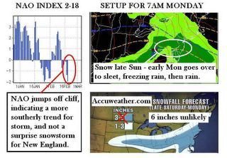
I started analysis with this event earlier in the week by saying computer models were trending the primary low too far north into the Great Lakes due to not seeing changes in the North Atlantic Oscillation. The original ballpark call was 3 to 12 inches, but the latter part of that was just an upper boundary to set a limit on the realm of possibility with this storm. On Friday I narrowed this to a general 2-3” for the I-95 corridor, with higher amounts in the Appalachians.
Now that the NAO has tanked as shown above, I think this happened too late in the game for models to adequately pick up on the rapid switch to negative. As a result, our storm will probably cut over to Erie or perhaps even Pittsburgh, then a secondary develops around Delaware, and moves east-north-east out to sea. Some wraparound precip will clip Southern New England, but it is a fast moving system. Warm air intrusion in the second phase of development will cut down on heavy accumulations due to a lower liquid to snow ratio, as well as a changeover of snow to sleet and freezing rain. Computer models have been trending back to a warmer solution the past few days, but as of late, the NWS has decided to interpret that as model error because of their concern over the computers not picking up on the impact of evaporative cooling, which tends to allow more snow than models indicate.
As a result, some of my amounts will be adjusted slightly since I think the negative NAO and high pressure issues are going to enhance snow rates for a couple hours before it changes over and departs.
STORM GRADE TOTALS FOR SNOWFALL
I doubt that any widespread 6 inch amounts will be observed. Those amounts can occur in the Pennsylvania Poconos and in some spots of northwestern and central Pennsylvania. I believe the overall trend will be 3-4 inches throughout the “WHITE OVAL” that circles portions of the Mid-Atlantic on the graphic above. Snow rates may be 1-2 inches an hour for perhaps 2 hours, hence the idea of up to 4 inches. There is always the possibility that that snow falls a little longer than we think it will, thus the reason for isolated spots of 5-6 inches, but I emphasize this will be extremely isolated and I really have no idea where those places might be.
For our regular readers, this is a roundup of forecasted amounts for your area by Monday noon after which all snow changes to rain from south to north.
Martinsburg, WV: 3 inches / Altoona, PA: 4 inches / State College, PA: 5 inches
Paoli, PA (SE area): 4 inches / York, PA: 5 inches / Bucks County, PA: 6 inches
Philadelphia: 3 inches (measured at PHL airport)
Northern Virginia/Loudon County/Washington: 3 inches (measured at Dulles)
Baltimore, MD : 2 inches (at BWI) / Towson, MD: 4 inches / Parkton, MD: 5 inches
Dundalk, MD : 3.5 inches (measured in Mr. Foot's backyard)
New York City: 2.5 inches (Central Park) / Boston, MA: 4.5 inches (Logan Airport)
Woburn, MA: 5 inches (revision...measured at a reader's home)
THE AMOUNTS SEEM LOW? WHY?
Because the timing of the storm will allow for snow from southwest to northeast, but since the northeast portions, Philly to Boston will be occurring later on Monday, I believe that daytime heating will make for a changeover to rain before ending, limiting accumulations. I also have a suspicion that this will not come as far north if it ends up going more south, the jet stream would have a tendency to send it out to sea instead of curving up the coast.
The introduction of the second High may recharge the storm with enough cold air to raise liquid-to-snow ratios to the normal 10:1. I have made a final set of adjustments to my numbers to reflect this. In Boston for example, a QPF of .6 with a 10:1 ratio means 6 inches, which seems high to me, so I'm knocking it back a bit to 4.5". I use this example to illustrate that I want to post a number that I feel very confident is a guaranteed minimum amount for a certain area.
IS THERE A CHANCE THIS STORM COULD CHANGE AND SURPRISE US ALL?
You mean like will you wake up to 6 inches of wind-whipped powder because the secondary formed sooner than expected and stayed longer, pulling in cold air from Canada which increased liquid to snow rations, hence 6 inches instead of 2-4? I don’t think so because the semi-Arctic high will be departing with the storm, and the big fresh one waiting in the winds in upstate New York is going to be overrun by warm air instrusion from the southwest. Were that to somehow magically occur, we would be looking at a different setup, but it is not in the cards this time. In all fairness to powderhounds, IF something weird starts to happen, I will be on it like hair on a gorilla.
Sunday Morning Comment: Now that Winter Storm Warnings are blanketing northern/central MD, and most of PA except for SW corner, I think that my forecasting for this storm will fall in line with expectations. I would like to point out that you got an advance knowledge of a snowfall range first, and then direct accumulation numbers were posted HERE before NWS or Accuweather made public statements about it.